Tian Shan facts for kids
Quick facts for kids Tian Shan |
|
|---|---|
| 天山 | |

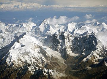
The Tian Shan range on the border between China and Kyrgyzstan with Khan Tengri (7,010 m) visible at center
|
|
| Highest point | |
| Peak | Jengish Chokusu |
| Elevation | 7,439 m (24,406 ft) |
| Geography | |
| Countries | |
| Range coordinates | 42°N 80°E / 42°N 80°E |
| Geology | |
| Age of rock | Mesozoic and Cenozoic |
| Official name: Xinjiang Tianshan | |
| Type: | Natural |
| Criteria: | vii, ix |
| Designated: | 2013 (37th session) |
| Reference #: | 1414 |
| State Party: | China |
| Region: | Asia |
| Official name: Western Tien-Shan | |
| Type: | Natural |
| Criteria: | x |
| Designated: | 2016 (40th session) |
| Reference #: | 1490 |
| State Party: | Kazakhstan, Kyrgyzstan and Uzbekistan |
| Region: | Asia |
The Tian Shan is a huge system of mountain ranges in Central Asia. Its name means "Mountains of Heaven" or "Heavenly Mountains" in Chinese. These mountains stretch across several countries. These include China, Kazakhstan, Kyrgyzstan, Uzbekistan, and Tajikistan.
The tallest mountain in the Tian Shan range is Jengish Chokusu. It stands at an amazing 7,439 metres (24,406 ft) (about 24,406 feet) high. Another very tall peak is Khan Tengri, which is 7,010 meters tall.
The Tian Shan mountains are very important. Parts of them have been named UNESCO World Heritage Sites. The eastern part in China became a World Heritage Site in 2013. The western part, which is in Kazakhstan, Uzbekistan, and Kyrgyzstan, became a World Heritage Site in 2016. This means they are special places protected for everyone to enjoy.
For a long time, the Tian Shan mountains were a key part of the ancient North Silk Road. This was a famous trade route. Travelers used to follow the mountain range. This helped them cross the Taklamakan Desert safely. The Silk Road connected East Asia with the Middle East.
Contents
Geography of Tian Shan
The Tian Shan mountain system is one of the largest in the world. It stretches for about 2,500 kilometers (1,550 miles). The range runs from east to west. It forms a natural border between different regions.
Countries and Peaks
The mountains are mainly found in China and Kyrgyzstan. However, parts also extend into Kazakhstan, Uzbekistan, and Tajikistan. The highest point is Jengish Chokusu. It is located on the border between Kyrgyzstan and China. Many other peaks in the range are also very high. They are often covered in snow and ice.
Lakes and Valleys
The Tian Shan region has beautiful lakes and deep valleys. One famous lake is Issyk-Kul Lake in Kyrgyzstan. It is one of the largest mountain lakes in the world. The mountains also have many rivers. These rivers are fed by melting glaciers and snow. They provide water for the surrounding areas.
Climate and Environment
The climate in the Tian Shan mountains varies a lot. It depends on how high you are. The lower parts can be dry. The higher parts are very cold. They have lots of snow and ice.
Glaciers and Ecosystems
The Tian Shan is home to many glaciers. These huge ice formations are important. They store water and slowly release it. This water is vital for plants, animals, and people living nearby. The mountains also have different types of environments. These include deserts, grasslands, forests, and high mountain areas. Each area supports unique plants and animals.
Historical Importance of Tian Shan
The Tian Shan mountains played a big role in history. They were a natural barrier and a guide for travelers.
The Silk Road Connection
The ancient Silk Road was a network of trade routes. It connected the East and West for thousands of years. Merchants, explorers, and missionaries traveled along these routes. They carried goods like silk, spices, and ideas. The northern branch of the Silk Road passed right by the Tian Shan mountains. This made the mountains a landmark for travelers. They would follow the mountain range to avoid the harsh desert.
Cultural Exchange
Because of the Silk Road, the Tian Shan region became a place of cultural exchange. Different peoples met and traded. This led to a rich mix of traditions, languages, and religions. The mountains witnessed centuries of human history unfold along their slopes.
World Heritage Status
The UNESCO World Heritage Site status is very important for the Tian Shan mountains. It recognizes their unique natural value.
Why Tian Shan is Special
The eastern part of Tian Shan in China is special for its unique landscapes. It has beautiful valleys, forests, and snow-capped peaks. The western part, shared by Kazakhstan, Kyrgyzstan, and Uzbekistan, is recognized for its biodiversity. It is home to many rare and endangered species. This protection helps keep these natural treasures safe for future generations.
Images for kids
-
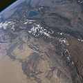
Tian Shan Mountains from space, October 1997, with Issyk-Kul Lake in Kyrgyzstan at the northern end
-
Tian Shan with the ancient silk road
See also
 In Spanish: Tian Shan para niños
 | Leon Lynch |
 | Milton P. Webster |
 | Ferdinand Smith |


