
Sleeping Bear Dunes National Lakeshore facts for kids
Quick facts for kids Sleeping Bear Dunes National Lakeshore |
|
|---|---|
|
IUCN Category III (Natural Monument)
|
|
| Location | Benzie and Leelanau counties, Michigan, United States |
| Nearest city | Empire, Michigan Glen Arbor, Michigan |
| Area | 71,199 acres (288.13 km2) |
| Established | October 21, 1970 |
| Visitors | 1,501,117 (in 2022) |
| Governing body | National Park Service |
| Website | Sleeping Bear Dunes National Lakeshore |
The Sleeping Bear Dunes National Lakeshore is a special natural area in Michigan, United States. It's located on the northwestern side of Michigan's Lower Peninsula. This beautiful park stretches for about 35 miles (56 kilometers) along the eastern shore of Lake Michigan. It also includes North Manitou Island and South Manitou Island.
The park covers a huge area of about 71,199 acres (288 square kilometers). It's famous for its amazing sand dunes, thick forests, lovely beaches, and cool features left behind by ancient glaciers. You can also find interesting historical places here, like the South Manitou Island Lighthouse built in 1871. There are also old Coast Guard stations and historic farms.
The National Park Service takes care of this park. It was officially created on October 21, 1970. In 2011, a TV show called Good Morning America even called it "The Most Beautiful Place in America"! A part of the park was also named the Sleeping Bear Dunes Wilderness in 2014. This means that part of the park is kept very wild and natural.
Contents
Exploring Sleeping Bear Dunes

Sleeping Bear Dunes National Lakeshore protects a huge part of the Lake Michigan shoreline. Most of this area is on the Leelanau Peninsula. This is a big piece of land that sticks out into the lake in northwest Michigan. The park is about 20 miles (32 kilometers) west of Traverse City. Traverse City is the biggest city in Northern Michigan.
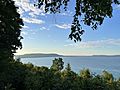
The southern part of the park is flatter. It includes Platte Bay and where the Platte River flows into Lake Michigan. The northern parts of the park have more hills and dunes. Here you'll find the famous dune climb, Empire Bluff, Pyramid Point, and the Pierce Stocking Scenic Drive. A lot of this area is next to Glen Lake, which is Michigan's 18th largest lake.
The park also includes two islands: North Manitou Island and South Manitou Island. You can reach these islands by taking a ferry from Leland.
Two scenic roads, M-22 and M-109, run through the park. The M-22 road sign has become a popular symbol for visitors!
Nearby Towns
The towns closest to the park are Empire and Glen Arbor. Empire is where you'll find the main visitor center. This center is like the park's headquarters.
History of the Dunes
How the Land Was Formed

The amazing landscape you see at Sleeping Bear Dunes was shaped a very long time ago. This happened during the last Ice Age, about 10,000 to 14,000 years ago. Huge sheets of ice, called glaciers, moved across the land. When they melted, they left behind piles of sand and rocks. The tall dunes are actually "perched dunes." This means they are layers of sand blown by the wind, sitting on top of these old glacial deposits. Over many years, these dunes slowly move towards the east.
Creating the Park
The idea for Sleeping Bear Dunes National Park started in 1962. Senator Philip Hart worked hard to make it happen. The park was officially created on October 21, 1970. At first, some people living there were worried about their land becoming public. But the government wanted to protect this beautiful "third coast" of the Great Lakes. They helped local schools and included North Manitou Island in the park.
In 2014, a large part of the park, about 32,500 acres (13,152 hectares), became the Sleeping Bear Dunes Wilderness. This means this area is kept extra wild and natural. In 2022, the path of the Platte River was changed near where it flows into Lake Michigan.
The Legend of Sleeping Bear
The park gets its name from an old Ojibwe legend. It tells the story of a mother bear and her two cubs. A huge forest fire on the western side of Lake Michigan forced them into the water. They tried to swim to the other side. The two little cubs got tired and fell behind. The mother bear reached the shore and waited on a high bluff. Sadly, her cubs didn't make it out of the the lake.
The Great Spirit was touched by her strong love. So, the Spirit created two islands, North and South Manitou islands, to remember the cubs. The winds then covered the mother bear with sand, and she became the dunes. She is still waiting there today. The "bear" was once a small, tree-covered hill that looked like a sleeping bear from the water. Over time, wind and weather have made it much smaller.
Fun Activities at the Park
Dune Climb

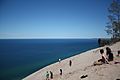
One of the most popular activities is climbing the huge sand dunes! The main dune climb is across from Glen Lake. If you come by car, you'll need a day pass or an annual pass from the National Park Service. You can also walk or bike to the dune climb. At the bottom of the main dune, you'll find water stations, restrooms, and a gift shop. You can even hike all the way to Lake Michigan from here.
Camping Adventures
Sleeping Bear Dunes National Lakeshore is a very popular place for camping. Many people love to camp here, especially since it was called "The Most Beautiful Place in America" in 2011. There are several campgrounds in the park.
- D.H. Day Campground is between Glen Arbor and Glen Haven. It offers private, wooded campsites near a Lake Michigan beach. You can easily visit Empire Bluffs, the dune climb, and North Bar Lake from here.
- Platte River Campground is in Benzie County. It has different types of campsites, some with electricity and some for hiking in. Nearby, you can explore Platte River Point, the Platte River, and Big Platte Lake. Kayaking is a favorite activity here, especially on the trail to Platte River Point.
You can also find campgrounds on the Manitou Islands. These include the Weather Station, Bay, and Popple campgrounds on South Manitou Island. Many other camping areas are also available near the park.
Hiking Trails
.jpg)
The park has many great hiking trails for you to explore. Some popular ones include the Alligator Hill Trail, Empire Bluff Trail, Kettles Trail, Pyramid Point Trail, and Treat Farm Trail. The Empire Bluff Trail is one of the most loved hikes in the park. Remember to get a parking pass from the visitor center in Empire before you start your hike.
Historic Places to See
Glen Haven Village
.jpg)
Glen Haven was a busy village from 1865 to 1931. It started as a dock for ships and became a place where ships could get wood for fuel. Charles McCarty built the Sleeping Bear House here in 1863, which later became an inn for travelers. There was also a General Store where workers could buy supplies. The Blacksmith Shop was where tools were fixed. Later, coal replaced wood for ships, and the town changed.
Port Oneida Historic Farm District
In 1860, Port Oneida was a small farming community. Thomas Kelderhouse built a dock to sell wood, fresh food, and maple sugar to passing ships. A local story says the area was named after the first ship to stop there, the SS Oneida. This district covers about 3,000 acres (12 square kilometers) and has 16 historic farms. Over time, farming became difficult, and many families moved away.
Pierce Stocking Scenic Drive

The Pierce Stocking Scenic Drive is a beautiful road inside the park. It's known for its amazing views and gentle curves. This 7.4-mile (11.9-kilometer) road offers stunning sights of Lake Michigan, Glen Lake, and the surrounding parkland. You can find it off M-109, between Empire and Glen Haven.
Kayaking Fun
.jpg)
Kayaking is a very popular activity in the park's rivers and lakes. You can enjoy paddling in the Crystal River and the Platte River.
Climate
| Climate data for Traverse City, Michigan | |||||||||||||
|---|---|---|---|---|---|---|---|---|---|---|---|---|---|
| Month | Jan | Feb | Mar | Apr | May | Jun | Jul | Aug | Sep | Oct | Nov | Dec | Year |
| Mean daily maximum °F (°C) | 29 (−2) |
29 (−2) |
37 (3) |
54 (12) |
64 (18) |
75 (24) |
81 (27) |
78 (26) |
71 (22) |
60 (16) |
44 (7) |
33 (1) |
55 (13) |
| Mean daily minimum °F (°C) | 15 (−9) |
11 (−12) |
21 (−6) |
32 (0) |
41 (5) |
52 (11) |
59 (15) |
58 (14) |
51 (11) |
41 (5) |
31 (−1) |
21 (−6) |
36 (2) |
| Average rainfall inches (mm) | 1.9 (48) |
1.5 (38) |
1.8 (46) |
2.3 (58) |
2.8 (71) |
2.5 (64) |
2.8 (71) |
2.7 (69) |
3 (76) |
2.8 (71) |
2.7 (69) |
1.8 (46) |
28.6 (730) |
| Average snowfall inches (cm) | 19.9 (51) |
16.2 (41) |
12.1 (31) |
3 (7.6) |
0.3 (0.76) |
0.0 (0.0) |
0.0 (0.0) |
0.0 (0.0) |
0.0 (0.0) |
0.7 (1.8) |
8.8 (22) |
16.5 (42) |
77.5 (197) |
The weather at Sleeping Bear Dunes National Lakeshore changes with the seasons. Summers are warm, perfect for swimming and hiking. Winters bring snow, making the landscape beautiful and quiet.
Protecting Wildlife
The piping plover is a small bird that is an endangered species. These special birds build their nests at Sleeping Bear Dunes National Lakeshore. The park helps protect them so they can survive and thrive.
Images for kids
-

Sign along M-22
-
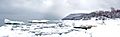
The lakeshore during winter
-
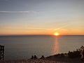
View from Pierce Stocking Scenic Drive at Sunset
-
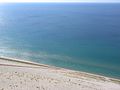
View from Lake Michigan Overlook, with people climbing up the dunes
-
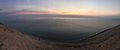
Sunset over Lake Michigan
-
Glen Lake from Inspiration Point
-
Dune Overlook
-
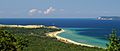
Sleeping Bear Point and South Manitou Island (background) from Alligator Hill
-
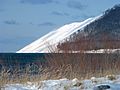
Sleeping Bear Bluff in Winter
.JPG)


.jpg)
.jpg)
See also
- Sand dune
- Pierce Stocking Scenic Drive
- List of areas in the National Park System of the United States
