North Manitou Island facts for kids
| Geography | |
|---|---|
| Location | Lake Michigan, Sleeping Bear Dunes National Lakeshore |
| Coordinates | 45°07′10″N 86°01′01″W / 45.11944°N 86.01694°W |
| Area | 22.3 sq mi (58 km2) |
| Highest elevation | 728 ft (221.9 m) |
| Administration | |
|
United States
|
|
| State | Michigan |
| County | Leelanau County |
| Township | Leland Township |
| Demographics | |
| Population | Uninhabited |
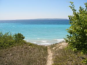
North Manitou Island is a beautiful island in Lake Michigan. It's about 12 miles (19 km) west-northwest of Leland, Michigan. The island is almost eight miles long and over four miles (6 km) wide. It has 20 miles (32 km) of shoreline. The island covers 57.876 km2 (22.346 sq mi) of land. No one lives on North Manitou Island today. Its smaller neighbor, South Manitou Island, is located to its southwest.
Contents
Exploring North Manitou Island
North Manitou Island looks like an upside-down teardrop. The wider part of the island, which is now covered in forests, surrounds Lake Manitou. The narrow "tail" of the island is a sandy area called Dimmick's Point. This point is on the island's southeastern side. The ferry dock and the ranger station are on the central eastern shore, right across from Lake Manitou.
Getting to the Island
The island is part of Leelanau County. It is also part of the Sleeping Bear Dunes National Lakeshore. Even though it's over 6 miles (9.7 km) offshore, you need park passes and camping fees to visit. You can reach the island by taking a ferry from Leland. You can also use your own boat, but docking is limited.
Rules for Visitors
No cars or other wheeled vehicles are allowed on the island. Only the National Park Service uses vehicles for work. You can't have campfires anywhere except in special fire pits near the ranger station. There's also only one water spigot and one outhouse in that same area.
Island History and Legends
North Manitou Island has a rich history, from ancient times to more recent settlements.
Native American Stories
The Ojibwe people have a legend about how the Manitou Islands and the Sleeping Bear Dunes were formed. A long time ago, a mother bear, Mishe Mokwa, and her two cubs tried to cross Lake Michigan. They were escaping a big forest fire. The mother bear made it across, but her two cubs drowned in the lake. The Great Spirit covered them with sand, creating the two Manitou islands. The mother bear, now the Sleeping Bear Dunes, still waits for her cubs to reach the shore.
Archeologists believe that Native Americans only stayed on the island for short periods. This is because the mainland had more natural resources. However, there are signs of Native American activity on the island. Some of the oldest archeological sites in Michigan are here. These seven sites are mostly on the east side. They date back to between 8,000 and 600 BC. People have found stone and flint tools, a copper awl, pottery, and parts of a canoe.
Early European Settlements
The first European settlers came to cut wood for the steamers that traveled on the Great Lakes. These boats used wood for fuel. Nicholas Pickard was likely the first woodcutter, arriving between 1842 and 1846. It's not clear if he owned land on North Manitou at first. Wood-cutting stations were also set up on South Manitou Island. Many early travelers wrote about visiting "the Manitous," but it's often hard to know which island they meant. Piers were built on both the eastern and western sides of North Manitou. This allowed steamers to load wood easily.
Life in the 20th Century
After wood-burning steamers were no longer used, more woodcutting happened on the island. This time, it was for lumber and raw logs. Companies like Smith & Hull (1906-1917) and Peter Stormer operated here. There was even a sawmill during World War II. Smith & Hull also ran a logging railroad called the "Manitou Limited." It used two Shay locomotives from 1909 until 1915.
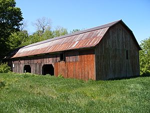
Some settlers on the island became farmers. They grew apples and cherries. You can still see parts of these old orchards today. From the late 1940s to the 1960s, the William R. Angell Foundation owned most of the island. They used the deer population for hunting. They even brought in salt blocks and special food from Kellogg Company to help the deer population grow. The deer kept the forests open and park-like by eating young plants. A 4,000-foot (1,200 m) lighted runway was built to bring hunters to the island. This area is now a field in "The Settlement" on the eastern side.
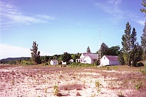
A summer community also grew on the east side of the island in the late 1800s. Wealthy Chicago businessmen built cottages there. Some of these cottages are still standing on "Cottage Row." The National Park Service now uses the old US Life-Saving Station grounds. This is near where the Leland ferry drops off campers. A lighthouse was built on the south end of the island in 1896. It became automatic in 1932, stopped working in 1938, and was destroyed in 1942.
After the Angell Foundation sold most of the island to the United States government, the deer population went down. This was because they no longer had extra food. The woods have grown back, and many open areas are now covered by trees. It's much harder to see deer today. Most buildings built after the 1950s have been taken down or are planned for demolition.
Even though North Manitou Island was sometimes less populated than South Manitou, it had apple and cherry orchards. Today, no one lives there except for National Park rangers and maintenance crews. The old homes and buildings of former settlers are now in ruins. Some buildings are supported during the summer. There is also a cemetery on the southeast side of the island where some former residents are buried.
North Manitou Island Today
The Manitou islands are surrounded by over 50 known shipwrecks. Some of these are popular and protected spots for diving.
Trails and Camping
The island has a network of trails. These are the remains of the island's old dirt roads. On the west side, you can still walk on the "old grade." This was the roadbed for the Smith & Hull logging railroad. You can camp anywhere in the wilderness on the island. There are also several special camping sites near the ranger station at the dock. You can get filtered water at the ranger station. There are not many natural water sources inland.
Lakes and Dunes
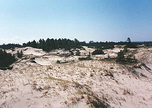
There is one large inland lake called Lake Manitou. It's good for fishing. Another lake, Tamarack Lake, is now mostly a cedar swamp. The island also has sand dunes on its northwest and southwest sides.
Island Wildlife
You can find several mammals on the island. These include coyotes, beavers, white-tailed deer, and eastern chipmunks. The raccoon population disappeared around 2002 due to disease. Many songbirds and waterfowl live here. The endangered piping plover is especially important. This bird nests on the island. People disturbing their nesting area near Dimmick’s Point can harm their ability to have babies. So, Dimmick’s Point is closed to hikers from May 1st to August 15th each year. Bald eagles are often seen, especially when they are nesting in spring and early summer. Garter snakes are also common on the island. There is an annual deer hunting season to help control the deer population.
Island Climate
|
||||||||||||||||||||||||||||||||||||||||||||||||||||||||||||||||||||||||||||||||||||||||||||||||
 | Frances Mary Albrier |
 | Whitney Young |
 | Muhammad Ali |


