Glen Arbor Township, Michigan facts for kids
Quick facts for kids
Glen Arbor Township, Michigan
|
|
|---|---|

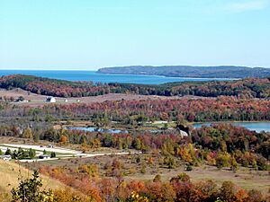
Rolling terrain of Glen Arbor Township, with Lake Michigan in the background
|
|

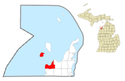
Location within Leelanau County
|
|
| Country | |
| State | |
| County | |
| Area | |
| • Total | 87.6 sq mi (226.8 km2) |
| • Land | 28.6 sq mi (74.0 km2) |
| • Water | 59.0 sq mi (152.8 km2) |
| Elevation | 581 ft (177 m) |
| Population
(2020)
|
|
| • Total | 757 |
| • Density | 8.642/sq mi (3.3377/km2) |
| Time zone | UTC-5 (Eastern (EST)) |
| • Summer (DST) | UTC-4 (EDT) |
| ZIP code(s) |
49636
|
| Area code(s) | 231 |
| FIPS code | 26-32380 |
| GNIS feature ID | 1626359 |
Glen Arbor Township is a cool place in Leelanau County, Michigan, USA. In 2020, about 757 people lived there. But during the summer, many more people come to visit! It becomes a busy summer colony.
The small town of Glen Arbor is inside this township. Also, South Manitou Island is part of Glen Arbor Township.
Contents
History of Glen Arbor Township
Early Settlers and Growth
The first known settler, John LaRue, moved here in 1848. He came from South Manitou Island to the area of Sleeping Bear Bay. John LaRue started a trading post. Soon, other people began to move to the area.
In 1854, a woman named Mrs. John E. Fisher gave the town its name, "Glen Arbor." Other important settlers helped the town grow. John Dorsey opened a shop to make barrels. C.C. McCarty built the Sleeping Bear Inn. It was first a home for people who worked with lumber.
In 1856, George Ray built a dock. He also became the first postmaster for the settlement. In 1864, W. D. Burdick built a sawmill and a grist mill nearby. These mills helped process wood and grain.
Development and Industry
In 1878, D. H. Day became interested in Glen Arbor. He was a land developer and worked for a shipping company. The famous barn across from the Sleeping Bear Dunes is named after him.
In the mid-1800s, the town's economy was mostly about the lumber industry. Wood was very important for building houses. It also fueled the steamboats that traveled the Great Lakes.
Life-Saving Station and Tourism
Many ships traveled through the Manitou Passage. Shipwrecks were a constant danger. So, in 1901, the U.S. Life-Saving Service built a small boat station. It was located at Sleeping Bear Point.
In 1931, the U.S. Coast Guard moved the station. It went to its current spot near Glen Haven. The station closed in 1944. Today, it is a maritime museum run by the National Park Service.
Over the years, Glen Arbor has grown. Many summer homes and resorts have been built. Today, the main industry is tourism, especially in the summer.
Geography of Glen Arbor Township
Glen Arbor Township covers about 87.6 square miles (226.8 square kilometers). A large part of this area, about 59.0 square miles (152.8 square kilometers), is water.
Natural Wonders and Waterways

The township is located along the Sleeping Bear Dunes National Lakeshore. In 2011, this area was called the "Most Beautiful Place in America." This was by the TV show Good Morning America.
The town has Glen Lake to its east. To its west is Lake Michigan. Glen Lake is a popular spot for visitors. It has warm, clear, turquoise blue water.
The Crystal River (Michigan) flows through the township. It is about 6.3 miles long. The river goes from Glen Lake to Lake Michigan. It is popular for fly fisherman and kayakers. They enjoy its clear water and beautiful wildlife.
South Manitou Island
South Manitou Island is managed by the National Park Service. Even though it's an island, it is politically part of Glen Arbor Township.
Main Roads
 M-22 comes into the township from the south. It then turns east in downtown Glen Arbor.
- M-109 enters the township from the west. It ends where it meets M-22 in Glen Arbor.
Communities in Glen Arbor Township
- Glen Arbor is the main community. It is where most people live in the township.
- Glen Haven is a historic community. It is an unincorporated area located west of Glen Arbor.
See also
 In Spanish: Municipio de Glen Arbor para niños
 | Chris Smalls |
 | Fred Hampton |
 | Ralph Abernathy |


