South Manitou Island facts for kids
| Geography | |
|---|---|
| Location | Lake Michigan, Sleeping Bear Dunes National Lakeshore |
| Coordinates | 45°1′40″N 86°7′10″W / 45.02778°N 86.11944°W |
| Area | 8.2 sq mi (21 km2) |
| Highest elevation | 610 ft (186 m) |
| Administration | |
| State | Michigan |
| County | Leelanau County |
| Township | Glen Arbor Township |
| Demographics | |
| Population | 1 year round resident |
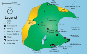
South Manitou Island is a beautiful island in Lake Michigan. It is about 16 miles (26 km) west of Leland, Michigan. The island is part of Leelanau County. It is also part of the amazing Sleeping Bear Dunes National Lakeshore.
The island is 8.277 sq mi (21.44 km2) in size. It has only one person living there all year. You can get to the island by taking a ferry from Leland. Visitors can explore the island on guided tours in open-air vehicles. Most people, however, enjoy walking around. A larger island, North Manitou Island, is located just north of South Manitou.
South Manitou Island is about 3 miles (4.8 km) wide and 3 miles (4.8 km) long. It is part of a chain of islands that stretches north. This chain goes all the way to the Straits of Mackinac. The island has a ridge of slanted limestone layers. These layers are covered by rocks and dirt left by glaciers. Huge glaciers carved out the Lake Michigan basin a long time ago. When the basin filled with water, the tops of the ridge became islands. Winds later blew sand from the high bluffs on the west side. This sand formed the dunes you can see today. Florence Lake is the only lake on the island. The island also has many trails and campsites for visitors.
Some of the oldest and largest trees in the world grow on the island. These are Northern white cedars. They are found on the southwestern part of the island. The biggest tree is 18 ft (5.5 m) around. Experts believe it is more than 500 years old!
Island History
South Manitou Island was first settled in the mid-1830s. A man named William Burton started a settlement there. His goal was to provide wood for the steamships on the Great Lakes. His dock was in a crescent-shaped bay on the east side of the island. This bay was the only natural deep-water harbor between Chicago and Buffalo.
By 1847, the village had grown. It included Burton's Wharf, a house, and a blacksmith shop. There was also a grocery store and a barn. A wooden railroad track ran from the dock inland. It was used to carry wood for the steamers. The first post office opened here in 1870.
Later, the logging business ended. The old dock fell apart. The original village became smaller and less important. In 1923, Burdick's general store moved. It went from the old dock area to a spot near the Lifesaving station. This new location was on the southeastern shore. This move changed where the island community was. The main village moved to the current dock area, where the ferry arrives today.
Farming slowly grew on the island. By 1870, most islanders grew their own food. They sold extra crops to passing ships and mainland markets. The island was isolated, which was great for growing special rye, beans, and peas. These crops often won awards. Today, no farms are active on the island. But old farm buildings, broken machinery, the school, and the cemetery remind us of the past. The island is mostly empty now, and many old buildings are in ruins.
Lighthouse and Life-Saving Station
In the 1800s and early 1900s, South Manitou Island was a busy spot. It was a popular harbor and a place for ships to refuel. After the Erie Canal opened in 1826, more and more ships sailed on the Great Lakes. The Manitou Passage was a very important route. It was used by ships traveling the 300-mile length of Lake Michigan. The island was a key stop for sailors going between Chicago and the Straits of Mackinac.
To help guide ships in storms, a lighthouse was needed. In 1838, Congress approved money to build one. Construction started in 1839. Not much is known about this first lighthouse. It was likely a house with a light tower on one end. It stood on a sandy hill near where the current lighthouse is.
In 1858, the U.S. Lighthouse Establishment decided a better light was needed. They replaced the old house with a two-story brick building. It had a 35-foot tower on top. This tower held a special lens called a Fourth Order Fresnel lens. A building for a fog signal was also added. Both of these buildings are still standing today.
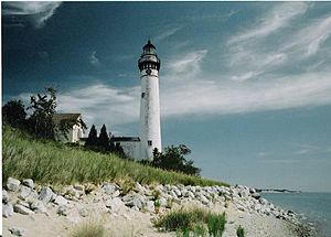
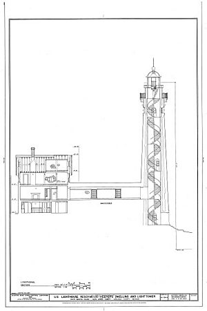
More ships meant more changes. In 1871, a taller, 100-foot tower was built. This tower is 18 feet wide at the bottom. Its walls are hollow and 5 feet thick at the base. They get thinner towards the top. A walkway was added to connect the tower to the keeper's house. A Third Order Fresnel lens from Paris was installed. It had a 3-wick lamp that could be seen from 18 miles away. In 1875, the first steam fog signal on Lake Michigan was put here. It replaced the old fog bell. The 100-foot lighthouse worked from 1871 until 1958. The lighthouse is still in good shape. Recently, its light tower was fixed. It now works again during the summer months.
In 1901, the United States Life-Saving Service built a station on the island. This service later became part of the United States Coast Guard in 1915. The station closed permanently in 1958. Today, this building is the island's ranger station. It is not open to the public.
Shipwrecks Around the Island
More than 50 known shipwrecks surround the Manitou islands. Some of these are popular places for divers to explore. In 1988, a special preserve was created. Its goal is to protect the history and archaeology of these shipwreck sites. The wrecks date from 1835 to 1960.
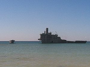
One famous shipwreck is the Francisco Morazan. This ship ran aground and was completely lost in 1960. It happened off the south shore of the island. The Morazan actually ran over the wreck of another ship. This was the bulk freighter Walter L Frost. The Frost had been stranded there since November 4, 1903. It was carrying corn and other goods.
The east side of the island has a large, round bay. This bay is very deep until you get close to the shore. Many times, ships found this bay to be a safe place during a storm. Even very large ships, called bulk carriers, used it. During the "Big Blow" of 1913, a captain named John Stufflebeam saved his ship. He pushed the front of his passenger steamer, the Illinois, onto the beach. He kept the engines running at full power for 49 hours. This stopped the strong winds from blowing the ship back out to sea. Later, he sent two sailors ashore to tie the ship to a strong tree. When the storm calmed down 24 hours later, he untied the ship. He put his engines in reverse and backed away from the shore. Then, he continued his journey safely.
See also
 In Spanish: Isla Manitou del Sur para niños
 | Anna J. Cooper |
 | Mary McLeod Bethune |
 | Lillie Mae Bradford |


