
Intracoastal Waterway facts for kids
Quick facts for kids Intracoastal Waterway |
|
|---|---|

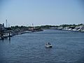
Intracoastal Waterway at Sunrise Boulevard, Fort Lauderdale, Florida, 2010
|
|
| Country | United States |
| Specifications | |
| Length | 3,000 miles (4,800 km) |
| History | |
| Date completed | June 18, 1949 |
| Geography | |
| Start point | Annisquam River |
| End point | Brownsville, Texas |
| Branch(es) | Gulf Intracoastal Waterway |
| Connects to | Atlantic portion Gulf portion |

The Intracoastal Waterway (ICW) is a very long water highway in the United States. It stretches about 3,000 miles (4,800 km) along the Atlantic and Gulf of Mexico coasts. It goes from Boston, Massachusetts, all the way south around Florida, and then along the Gulf Coast to Brownsville, Texas.
This waterway is special because it uses a mix of natural rivers, bays, and sounds, along with man-made canals. It creates a safe path for boats and ships. This route helps them avoid many dangers of traveling on the open ocean.
Contents
History of the Waterway
Early Ideas for Water Travel
Long ago, the U.S. government knew that water travel was very important for trade. In 1808, a plan was made to improve transportation across the country. This plan included connecting many of the waterways that now form the Intracoastal Waterway.
Albert Gallatin, who was the Treasury Secretary, suggested building canals to link natural waterways. This would create a safe route from Massachusetts to Georgia. It would protect ships from storms and enemies.
Why the Waterway Was Needed
The War of 1812 showed how important these inland waterways were. During the war, the British blocked ocean routes. This made it hard to move goods. The need for a safe, inland path became very clear.
Because of this, the government started to build and improve waterways. The United States Army Corps of Engineers (USACE) has been in charge of keeping these waterways working since 1824.
Connecting the Coasts
Over time, many parts of Gallatin's original plan were built. For example, the Cape Cod Canal and parts of the Dismal Swamp Canal are still used today. These projects helped connect different parts of the coast.
The Intracoastal Waterway is also part of a bigger route called the Great Loop. This allows boats to travel almost all the way around the eastern U.S. by water, using very little open ocean travel.
Growth in the 1800s
In the 1800s, there was a lot of growth in the U.S. At first, the government focused more on building railroads than waterways. But people soon realized that waterways were still very important for moving goods.
Laws were passed to improve waterways and make sure they were free to use. This helped different types of transportation, like boats and trains, compete fairly. This was good for the country's economy.
The Waterway Today


The Intracoastal Waterway is made of three parts that are not directly connected.
- The first part goes from Brownsville, Texas, to Carrabelle, Florida.
- The second part starts at Tarpon Springs, Florida, and goes south to Fort Myers, Florida.
- The third part begins at Key West, Florida, and goes north to Portsmouth, Virginia.
The first two parts are called the Gulf Intracoastal Waterway. The third part is called the Atlantic Intracoastal Waterway (AIWW). There are gaps between these sections in Florida. This is because some planned canals were never finished due to environmental concerns.
North of Portsmouth, Virginia, the waterway continues unofficially to the Manasquan River in New Jersey. Its official northern end is the Annisquam River in Massachusetts, near Boston.
Who Uses the Waterway?
The Intracoastal Waterway is very busy!
- Commercial Use: Large barges carry goods like oil, food, building materials, and other products.
- Recreational Use: Many people use the waterway for fun in their boats.
- Snowbirds: In the fall and spring, many people called "snowbirds" use the waterway. They travel south for the winter and north for the summer.
- Safety: Boaters also use the ICW when the ocean is too rough or dangerous.
The waterway connects to many important rivers. This allows ships to travel inland to different cities. Some of these rivers include the Mississippi River, Alabama River, Savannah River, James River, Delaware River, Hudson River, and Connecticut River.
Natural Water Bodies in the ICW
Many natural water bodies are part of the Intracoastal Waterway system. These include:
- Albemarle Sound
- Apalachicola Bay
- St. Andrews Bay
- Aransas Bay
- Barnegat Bay
- Biscayne Bay
- Boca Ciega Bay
- Bogue Sound
- Bon Secour Bay
- Buzzards Bay
- Cape Cod Bay
- Cape Fear River
- Casco Bay
- Charleston Harbor
- Charlotte Harbor
- Chesapeake Bay
- Choctawhatchee Bay
- Connecticut River
- Corpus Christi Bay
- Delaware Bay
- East River
- Elizabeth River
- Galveston Bay
- Halifax River
- Hampton Roads
- Indian River Lagoon
- Laguna Madre
- Lake Worth Lagoon
- Little River
- Long Island Sound
- Mobile Bay
- Pensacola Bay
- Perdido Bay
- Waccamaw River
- Winyah Bay
East Coast Canals
Major Freight Canals
Other Canals

- Albemarle and Chesapeake Canal
- Dismal Swamp Canal
- Cape May Canal
- Delaware and Raritan Canal – This canal is no longer used or part of the ICW.
- Okeechobee Waterway
- Point Pleasant Canal
- Lewes and Rehoboth Canal
Images for kids
-

Intracoastal Waterway at Sunrise Boulevard, Fort Lauderdale, Florida, 2010
-
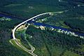
A section of the Intracoastal Waterway in Pamlico County, North Carolina crossed by the Hobucken Bridge
-
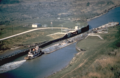
A tugboat and barge traveling on the Colorado River Locks on the Gulf Intracoastal Waterway near Matagorda, Texas
-
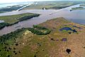
Boats on the Gulf Intracoastal Waterway, where it meets Bayou Perot, near New Orleans
-
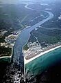
An aerial view of the Cape Cod Canal and Scusset Beach State Reservation in southeastern Massachusetts
-
The Lewes and Rehoboth Canal in Lewes, Delaware
See also
 In Spanish: Canal Intracostero del Atlántico para niños
