
Charlotte Harbor (estuary) facts for kids

The Charlotte Harbor Estuary is a huge bay on the west coast of Florida. It's the second largest bay in Florida! Most of it (about two-thirds) is in Charlotte County, Florida, and the rest is in Lee County. The harbor opens up to the Gulf of Mexico through a spot called the Boca Grande Pass. This pass is between Gasparilla Island and Lacosta Island.
Charlotte Harbor is a natural estuary, which is where fresh water from rivers mixes with salty ocean water. It stretches along Florida's west coast from Venice to Bonita Springs. This area is one of the most important wetlands in Florida. A wetland is a special area of land that is covered by water, like a swamp or marsh.
The estuary gets its water from a very large area called a watershed. This watershed includes the Peace River, the Caloosahatchee River, and the Myakka River. The whole system covers about 12,653 square kilometers (4,885 square miles). This makes it the second largest open water estuary in Florida!
Charlotte Harbor is a "bar-built" estuary. This means it formed when sandbars grew along the coastline. These sandbars act like a natural wall, separating the bay's waters from the open sea. Because of this, the harbor is usually shallow and doesn't have very strong tides.
This amazing natural area is facing some challenges. Fast growth and development, along with how land is used, can harm the environment. To protect it, the state of Florida created the Charlotte Harbor Aquatic Preserves in 1975. These preserves include important habitats like salt marshes, mangroves, seagrass beds, oyster reefs, and tidal flats. Many animals live here, including the American alligator, West Indian manatee, bald eagle, wood stork, piping plover, and different kinds of sea turtles like the green and loggerhead sea turtles. You might even spot a smalltooth sawfish!

Fresh water flows into the harbor from the Myakka River in the northwest and the Peace River in the northeast. Several towns are located around Charlotte Harbor, such as Boca Grande, Port Charlotte, Charlotte Harbor, Punta Gorda, and Bokeelia. To the south, Charlotte Harbor connects to San Carlos Bay through Pine Island Sound.
Contents
What's in a Name?
The name "Charlotte Harbor" comes from an older name. When the Spanish first arrived in the 1560s, the leader of the Calusa people was known as Carlos. So, the Spanish called the bay "Bahia Carlos," or Carlos Bay. Later, the English changed the name from Carlos to Charlotte. They did this to honor King George III's wife, Queen Charlotte.
A Look Back in Time

Before Europeans came, the Charlotte Harbor area was home to Native Americans. These people were part of the Calusa chiefdom, a powerful group that lived across southwest Florida. Their main village, Calos, was thought to be on Mound Key, just south of Charlotte Harbor.
Early Explorers
It's believed that Juan Ponce de León was the first European to visit Charlotte Harbor. He came in 1513 and again in 1521. During his visits, he and his soldiers met the Calusa people, who were not friendly. Ponce de Leon is thought to have died from a poisoned arrow wound he received there. Today, the spot where this conflict might have happened is Ponce de Leon Historical Park in Punta Gorda.
Another famous explorer, Hernando de Soto, began his journey across the Southeast in 1539. He landed on the west coast of Florida. While some historians think he landed near Tampa Bay, others believe he might have entered Florida through Charlotte Harbor.
Pirates and Shipwrecks
Have you ever heard of the pirate José Gaspar? He's also known as "Gasparilla." Stories say he sailed the Gulf of Mexico from his secret base in Charlotte Harbor from the late 1700s until 1821. He was said to have a "pirate kingdom" there! However, there's no real proof that Gaspar ever existed. He's a very popular figure in Florida folklore, though. The tales of this daring pirate and his lost treasure have been used to attract tourists to Charlotte Harbor and Florida's Gulf coast for many years. For example, Tampa has a big event called the Gasparilla Pirate Festival every year.
People also say that Charlotte Harbor was a hiding spot for another pirate, Brewster Baker. And many stories claim that ships full of Spanish gold sank in the harbor. Even though many people have searched for years, no treasure or evidence of a real pirate hideout has ever been found in the area.
Charlotte Harbor Today
Today, Charlotte Harbor is mostly used by private boats for fun and fishing. The area is a popular place for tourism. People come to enjoy the beautiful beaches and escape the cold winters. Many people also choose to retire in the Charlotte Harbor area.
Big Storms

Charlotte Harbor has been hit by several strong tropical storms and hurricanes. Records of these storms have been kept since 1851. Here are some of the tropical cyclones that have crossed Charlotte Harbor:
- 1894 Hurricane No. 4
- 1910 Hurricane No. 5
- 1925 Tropical Storm No. 4
- 1944 Hurricane No. 13
- 2004 Hurricane Charley
Hurricane Charley was a very strong storm that hit just south of Charlotte Harbor on Friday, August 13, 2004. It had winds of about 150 miles per hour (240 km/h) when it made landfall. Even as it moved inland towards Orlando, its winds were still very strong. The area received about 4 to 6 inches (10 to 15 cm) of rain from Charley.
Images for kids
-
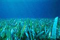
Florida seagrass
-
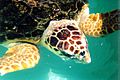
Loggerhead turtle (closeup)
-
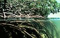
Coastal mangroves
-
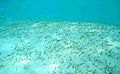
Florida seagrass bed


