
Caloosahatchee River facts for kids
The Caloosahatchee River is a river in southwest Florida, United States. It's about 67 miles (108 km) long. This river helps drain areas near the Everglades, east of Fort Myers. It's a key part of the Okeechobee Waterway. This waterway is a man-made system of rivers and canals in southern Florida. The Caloosahatchee River forms a tidal estuary for most of its length. People are working hard to restore and protect the Everglades and this river.

Contents
What is the Caloosahatchee River?

The Caloosahatchee River starts from Lake Hicpochee. This lake is in southeastern Glades County. The river flows west-southwest past LaBelle. Here, it becomes tidal, meaning its water levels change with the ocean's tides. This tidal part, called an estuary, is about 25 miles (40 km) long.
As the river gets closer to the Gulf of Mexico, it becomes wider. It flows past cities like Fort Myers and Cape Coral. The river finally enters the Gulf of Mexico about 10 miles (16 km) southwest of Fort Myers. It flows into San Carlos Bay, which is protected by Sanibel Island.
How the River Connects to Lake Okeechobee
A canal called the C-43 Caloosahatchee Canal connects Lake Hicpochee to Lake Okeechobee. This canal is about 5 miles (8 km) long. It allows boats to travel continuously from the Caloosahatchee River to the Okeechobee Waterway system. You can still see parts of the original river in some places. These are called oxbow lakes.
In 2013, there were very heavy rains in southern Florida. This caused a lot of water to flow into Lake Okeechobee. The lake's water level became very high. The United States Army Corps of Engineers had to release large amounts of water from the lake. This water was released into the St. Lucie River to the east and the Caloosahatchee River to the west. This changed the normal mix of fresh and salt water in these estuaries. It caused environmental problems for the plants and animals living there.
How the River Has Changed Over Time
Before the late 1800s, the Caloosahatchee River was fed by several lakes. These included Lake Hicpochee, Lettuce Lake, Bonnet Lake, and Flirt Lake. The river started with a waterfall and rapids below Lake Flirt. These rapids were about 1 mile (1.6 km) long and dropped about 10 feet (3 meters). Lake Hicpochee was close to Lake Okeechobee, but they were not connected. Water flowed from Lake Hicpochee into Lettuce Lake, then Bonnet Lake, and finally Lake Flirt. All these lakes were surrounded by large wetlands.
In 1881, a man named Hamilton Disston started a project. He wanted to drain large wetland areas in Florida. His company dug a canal from Lake Okeechobee to Lake Hicpochee. They continued digging through the lakes and wetlands to the west. They also removed the rock ledge that formed the waterfall and rapids below Lake Flirt. They straightened the upper parts of the Caloosahatchee River. Since then, different government projects have made the river wider and deeper. Turning the river into a canal drained Lake Flirt and the wetlands near Lake Hicpochee.
Since the late 1800s, the river has been changed a lot. Digging and straightening the river, connecting it to Lake Okeechobee, and using its water for cities and farms have all made a big difference. This has changed how much water flows into the estuary and when it flows. The state government has started programs to set minimum water flow levels for the river. This helps restore the water supply to the Everglades. A special wildlife refuge for manatees has also been created. It is at the mouth of the river in San Carlos Bay, near Fort Myers.
Bridges Over the Caloosahatchee River
Many bridges cross the Caloosahatchee River and its canal. Here is a list of some of them:
| Bridge | Route | Location | Notes |
|---|---|---|---|
| South Central Florida Express, Inc. | Moore Haven | Swing Bridge | |
| Mamie Langdale Memorial Bridge | Moore Haven | ||
| LaBelle | Bascule Bridge | ||
| Fort Denaud Bridge | Fort Denaud Road | Fort Denaud | Swing Bridge |
| Alva Bridge | Broadway | Alva | Bascule Bridge |
| Wilson Pigott Bridge | Fort Myers Shores | Bascule Bridge | |
| Tice | |||
| Seminole Gulf Railway | Tice | Bascule Bridge | |
| Edison Bridge | Fort Myers | ||
| Caloosahatchee Bridge | Fort Myers | ||
| Midpoint Memorial Bridge | Cape Coral | ||
| Cape Coral Bridge | Cape Coral |
Gallery
-
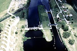
Ortona Lock and Dam on the Caloosahatchee River, part of the Okeechobee Waterway, in Glades County, Florida
-
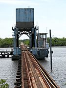
Seminole Gulf Railway spans the Caloosahatchee River near Tice, Florida.
-
The Midpoint Memorial Bridge spanning the river and connecting the cities of Cape Coral and Fort Myers (2008).


