Moore Haven, Florida facts for kids
Quick facts for kids
Moore Haven, Florida
|
|
|---|---|
| City of Moore Haven | |

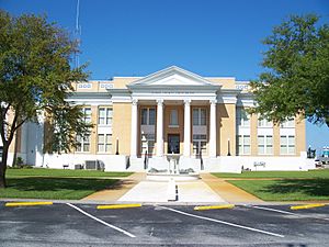
Glades County Courthouse
|
|
| Nickname(s):
Hooterville
|
|

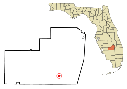
Location in Glades County and the state of Florida
|
|
| Country | |
| State | |
| County | Glades |
| Incorporated | 1917 |
| Government | |
| • Type | Council-Manager |
| Area | |
| • Total | 1.06 sq mi (2.76 km2) |
| • Land | 1.06 sq mi (2.76 km2) |
| • Water | 0.00 sq mi (0.00 km2) |
| Elevation | 13 ft (4 m) |
| Population
(2020)
|
|
| • Total | 1,566 |
| • Density | 1,470.42/sq mi (567.57/km2) |
| Time zone | UTC-5 (Eastern (EST)) |
| • Summer (DST) | UTC-4 (EDT) |
| ZIP code |
33471
|
| Area code(s) | 863 |
| FIPS code | 12-46550 |
| GNIS feature ID | 0287104 |
| Website | http://www.moorehaven.org |
Moore Haven is a city in Glades County, Florida, United States. It is the main city, or county seat, of Glades County. Moore Haven is located in the Florida Heartland region.
In 2020, about 1,566 people lived there. This was a small decrease from 1,680 people in 2010. The city sits on the southwest shore of Lake Okeechobee. It is also part of the larger Clewiston, Florida Micropolitan Statistical Area.
Contents
History of Moore Haven
The city of Moore Haven was named after its founder, James A. Moore (1861-1929). In its early days, people often called Moore Haven "Little Chicago." This was because it was a fast-growing and important town, also known as a boomtown. Its location was perfect, right where Lake Okeechobee met the Caloosahatchee Canal.
First Woman Mayor in the South
In 1917, something very special happened in Moore Haven. Marian Newhall Horwitz was elected mayor. She was not just the first woman mayor of Moore Haven or in Florida. She was the first female mayor south of the Mason–Dixon line, which divides the northern and southern United States.
The Moore Haven Times newspaper described Horwitz as very focused on business. They said she was often seen riding her horse to work at 5:15 AM. She stopped being mayor on June 22, 1918. This was because her second husband, John J. O'Brien, went to serve in World War I. She also decided to live on a farm outside the city limits.
After she left office, the people of Moore Haven gave her a silver trophy. This showed how thankful they were for her work. Her son, Dr. Orville Horwitz, received the trophy in 1985.
Bringing the Railroad to Moore Haven
Marian Horwitz is also known for helping bring the railroad to Moore Haven. Her brother was a business partner of J.P. Morgan. Morgan was the vice-president of the Atlantic Coast Line Railroad.
In 1918, the first train line was completed. Moore Haven's first train arrived on May 13, 1918. It had twenty passenger cars and fifteen freight cars. The train was ninety minutes late. The railroad often had problems like late arrivals and broken equipment. Trains would also sometimes go off the tracks.
People gave the train nicknames like the "Hinky Dink" and the "Muck Special." There was even a funny joke about the train. It said that a middle-aged man who got off the train in Moore Haven had started his journey as a young boy in Haines City. He had been left in the care of the conductor for the whole trip!
How Hurricanes Changed Moore Haven
Two big hurricanes greatly changed the area. The Great Miami Hurricane of 1926 caused a lot of damage. A huge storm surge from the lake brought widespread death and destruction. Some houses were even moved across the river by the water.
The town might have recovered, but then the 1928 Okeechobee Hurricane hit soon after. This second storm destroyed areas that had not been damaged in 1926.
Today, Moore Haven is a quiet, small town. It does not have much industry or big buildings. Moore Haven hosts the Annual Chalo Nitka Festival. This festival takes place on the first weekend of March each year.
There are two places in town where you can get onto the Lake Okeechobee Scenic Trail. This trail goes through Moore Haven and all around Lake Okeechobee.
The Mamie Langdale Memorial Bridge was built in 2000. It crosses the Caloosahatchee River about 900 feet east of First Street. This bridge holds a Florida record. It has the longest concrete I-girder span, measuring 320 feet. The entire bridge is 2,281 feet long.
The Westergaard House was built in 1920. It is located at 270 Avenue L Southwest. This house is now the main office for the Glades County Historical Society.
Geography of Moore Haven
Moore Haven is located at specific coordinates: 26°50′N 81°6′W / 26.833°N 81.100°W.
The United States Census Bureau says the city covers about 1.1 square miles (2.76 square kilometers). Most of this area is land. Only a small part, about 0.1 square miles (6.09%), is water.
Climate and Weather
Moore Haven has a humid subtropical climate. This means it has hot, humid summers and mild winters. It also has some features of a tropical monsoon climate, with a clear rainy season from June to September.
| Climate data for Moore Haven, Florida (Moore Haven Lock 1), 1991–2020 normals, extremes 1918–present | |||||||||||||
|---|---|---|---|---|---|---|---|---|---|---|---|---|---|
| Month | Jan | Feb | Mar | Apr | May | Jun | Jul | Aug | Sep | Oct | Nov | Dec | Year |
| Record high °F (°C) | 89 (32) |
91 (33) |
94 (34) |
97 (36) |
98 (37) |
101 (38) |
103 (39) |
98 (37) |
99 (37) |
98 (37) |
91 (33) |
95 (35) |
103 (39) |
| Mean maximum °F (°C) | 83.7 (28.7) |
85.8 (29.9) |
88.1 (31.2) |
91.3 (32.9) |
93.9 (34.4) |
95.3 (35.2) |
95.6 (35.3) |
95.5 (35.3) |
94.5 (34.7) |
91.8 (33.2) |
87.3 (30.7) |
85.1 (29.5) |
96.8 (36.0) |
| Mean daily maximum °F (°C) | 74.3 (23.5) |
77.2 (25.1) |
80.5 (26.9) |
84.9 (29.4) |
88.7 (31.5) |
90.9 (32.7) |
92.1 (33.4) |
92.2 (33.4) |
90.7 (32.6) |
86.3 (30.2) |
80.1 (26.7) |
76.7 (24.8) |
84.6 (29.2) |
| Daily mean °F (°C) | 62.2 (16.8) |
64.7 (18.2) |
67.5 (19.7) |
72.3 (22.4) |
76.7 (24.8) |
80.2 (26.8) |
81.5 (27.5) |
82.0 (27.8) |
80.9 (27.2) |
76.2 (24.6) |
69.5 (20.8) |
65.2 (18.4) |
73.2 (22.9) |
| Mean daily minimum °F (°C) | 50.1 (10.1) |
52.2 (11.2) |
54.6 (12.6) |
59.7 (15.4) |
64.6 (18.1) |
69.4 (20.8) |
71.0 (21.7) |
71.7 (22.1) |
71.1 (21.7) |
66.2 (19.0) |
58.9 (14.9) |
53.6 (12.0) |
61.9 (16.6) |
| Mean minimum °F (°C) | 35.9 (2.2) |
39.0 (3.9) |
43.3 (6.3) |
50.6 (10.3) |
59.0 (15.0) |
68.2 (20.1) |
70.2 (21.2) |
70.5 (21.4) |
68.9 (20.5) |
56.8 (13.8) |
47.1 (8.4) |
40.6 (4.8) |
33.7 (0.9) |
| Record low °F (°C) | 23 (−5) |
28 (−2) |
25 (−4) |
33 (1) |
47 (8) |
54 (12) |
60 (16) |
61 (16) |
58 (14) |
40 (4) |
31 (−1) |
23 (−5) |
23 (−5) |
| Average precipitation inches (mm) | 2.15 (55) |
2.02 (51) |
2.44 (62) |
2.43 (62) |
3.73 (95) |
8.43 (214) |
7.45 (189) |
7.87 (200) |
5.93 (151) |
2.89 (73) |
1.52 (39) |
1.76 (45) |
48.62 (1,235) |
| Average precipitation days (≥ 0.01 in) | 5.8 | 5.3 | 5.0 | 5.6 | 8.0 | 15.1 | 15.0 | 15.4 | 13.0 | 7.6 | 4.9 | 5.4 | 106.1 |
| Source: NOAA | |||||||||||||
Population and People
Here's how the population of Moore Haven has changed over the years:
| Historical population | |||
|---|---|---|---|
| Census | Pop. | %± | |
| 1920 | 623 | — | |
| 1930 | 612 | −1.8% | |
| 1940 | 831 | 35.8% | |
| 1950 | 636 | −23.5% | |
| 1960 | 790 | 24.2% | |
| 1970 | 974 | 23.3% | |
| 1980 | 1,250 | 28.3% | |
| 1990 | 1,432 | 14.6% | |
| 2000 | 1,635 | 14.2% | |
| 2010 | 1,680 | 2.8% | |
| 2020 | 1,566 | −6.8% | |
| U.S. Decennial Census | |||
Population in 2010 and 2020
The table below shows the different racial groups in Moore Haven. It separates people into racial categories, not including those of Hispanic or Latino background.
| Race | Pop 2010 | Pop 2020 | % 2010 | % 2020 |
|---|---|---|---|---|
| White (NH) | 659 | 546 | 39.23% | 34.87% |
| Black or African American (NH) | 407 | 403 | 24.23% | 25.73% |
| Native American or Alaska Native (NH) | 0 | 6 | 0.00% | 0.38% |
| Asian (NH) | 3 | 2 | 0.18% | 0.13% |
| Pacific Islander or Native Hawaiian (NH) | 0 | 0 | 0.00% | 0.00% |
| Some other race (NH) | 0 | 4 | 0.00% | 0.26% |
| Two or more races/Multiracial (NH) | 13 | 31 | 0.77% | 1.98% |
| Hispanic or Latino (any race) | 598 | 574 | 35.60% | 36.65% |
| Total | 1,680 | 1,566 |
In 2020, the 2020 United States census counted 1,566 people living in Moore Haven. There were 793 households and 422 families.
In 2010, the 2010 United States census counted 1,680 people. There were 744 households and 467 families living in the city.
Arts and Culture in Moore Haven
Moore Haven's Historic District
The Moore Haven Downtown Historic District is a special area in the U.S. that was recognized as historic in 1995. This district has seven old buildings that are important to the city's past. It also has a park with the only Cypress tree in the district.
Education
Moore Haven has schools for different age groups:
- Moore Haven Elementary School
- Moore Haven Middle-High School
Images for kids
See also
 In Spanish: Moore Haven para niños
 | John T. Biggers |
 | Thomas Blackshear |
 | Mark Bradford |
 | Beverly Buchanan |


