Lee County, Florida facts for kids
Quick facts for kids
Lee County
|
|||
|---|---|---|---|

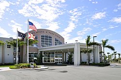
Base Operations at Page Field
|
|||
|
|||

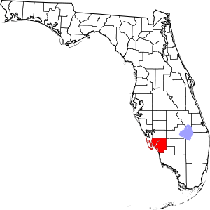
Location within the U.S. state of Florida
|
|||
 Florida's location within the U.S. |
|||
| Country | |||
| State | |||
| Founded | May 13, 1887 | ||
| Named for | Robert E. Lee | ||
| Seat | Fort Myers | ||
| Largest city | Cape Coral | ||
| Area | |||
| • Total | 1,212 sq mi (3,140 km2) | ||
| • Land | 785 sq mi (2,030 km2) | ||
| • Water | 428 sq mi (1,110 km2) 35.3%% | ||
| Population
(2020)
|
|||
| • Total | 760,822 | ||
| • Density | 969.2/sq mi (374.2/km2) | ||
| Time zone | UTC−5 (Eastern) | ||
| • Summer (DST) | UTC−4 (EDT) | ||
| Congressional districts | 17th, 19th | ||
Lee County is a place in southwestern Florida, United States. It is located right on the Gulf Coast. In 2020, about 760,822 people lived here. By 2022, the population grew to over 822,000, making it the eighth-largest county in Florida.
The main city, called the county seat, is Fort Myers. The biggest city in the county is Cape Coral. Lee County is part of a larger area called the Cape Coral–Fort Myers Metropolitan Statistical Area.
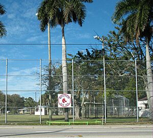
Lee County was created in 1887 from Monroe County. Fort Myers is a popular spot for tourists in Southwest Florida. It is about 120 miles (193 km) south of Tampa. The Gulf of Mexico and the Caloosahatchee River meet here. Lee County is also where the Boston Red Sox and Minnesota Twins baseball teams do their spring training.
Contents
History of Lee County
Early People and European Visitors (500–1799)
The land that is now Lee County has many old sites. These show that people from the Caloosahatchee culture lived here a long time ago (from 500 to 1750 AD). When Europeans first arrived, the Calusa people lived in this area.
Later, fishermen from Cuba and other Spanish places set up fishing camps. These camps were called ranchos. They were along the southern Gulf Coast of Florida. These camps helped start bigger European settlements later on. By the end of the 1700s, the Seminole people had moved into the area. In 1799, a Seminole town was noted on the "Cull-oo-saw-hat-che" or Caloosahatchee River.
Fort Myers is Built (1850s–1860s)
Florida became a U.S. territory in 1821. Many settlers moved in, which caused problems with the local Seminole Indians. Fort Myers was built in 1850 as a military fort. Its job was to protect settlers from the Seminole Indians during the Seminole Wars.
The fort was named after Colonel Abraham C. Myers. He was stationed in Florida for seven years. In 1858, after many battles, Chief Billy Bowlegs and his warriors agreed to move west. The fort was then left empty. Billy's Creek, which flows into the Caloosahatchee River, was named after a camp where Billy Bowlegs waited for ships.
In 1863, during the Civil War, federal troops used the fort again. In 1865, a small group of Confederates attacked the fort in the Battle of Fort Myers. The Union soldiers, led by Captain James Doyle, successfully defended the fort. After the war, the fort was left empty once more. Later, parts of the fort were taken apart. Some of its wood was used to build parts of downtown Fort Myers.
Early Growth and New Counties (1860s–1920s)
The first settlers in Fort Myers arrived in 1866. By the 1870s, a rich merchant named Tervio Padilla came to Cayo Costa. He traded with local people and the ranchos. His family became one of the first pioneer families in Lee County. Many of his family members still live in the Pine Island area.
In 1885, Fort Myers became an official town. It had 349 residents, making it the second-largest city on Florida's west coast south of Cedar Key. Lee County was officially formed in 1887 from Monroe County. Fort Myers became the county seat. The county was named after Robert E. Lee, a general from the Civil War.
Fort Myers became a famous winter resort in 1898. This was when the Royal Palm Hotel opened. Famous people like Thomas Edison and Henry Ford often spent their winters here. In 1911, Fort Myers became a city. In 1923, Collier and Hendry Counties were created from parts of Lee County.
The building of the Tamiami Trail Bridge in 1924 helped the city grow a lot. After the bridge, many new neighborhoods appeared. In 1927, land bought by Fort Myers became an airport, later called Page Field.
Modern Times and Growth (1940s–Present)
During World War II, Page Field was used as a training base for fighter planes. After the war, it became a commercial airport. Another airfield, Buckingham Army Airfield, was built in 1942. It closed in 1945.
Lee County has hosted several Major League Baseball teams for spring training over the years. The county grew even more in 1983 when Southwest Florida Regional Airport opened. This airport is now known as Southwest Florida International Airport.
Hurricanes
Lee County has been hit by strong hurricanes.
- On August 13, 2004, Hurricane Charley, a very strong Category 4 storm, hit the northwestern islands like Captiva and Gasparilla.
- On September 10, 2017, Hurricane Irma hit as a Category 2 storm.
- On September 28, 2022, Hurricane Ian made landfall as a Category 4 storm. It caused huge damage to Sanibel, Pine Island, and nearby areas. The Sanibel Causeway partly broke apart. Sadly, 71 people died in Lee County because of Hurricane Ian by October 4.
Geography
Lee County covers about 1,212 square miles (3,139 sq km). About 428 square miles (1,109 sq km) of this is water, which is about 35% of the total area. Important rivers include the Caloosahatchee River and the Imperial River.
Lee County is on the southwest coast of Florida. It is about 125 miles (201 km) south of Tampa. It is also about 115 miles (185 km) west of Fort Lauderdale and 125 miles (201 km) west-northwest of Miami.
Neighboring Counties
- Charlotte County (north)
- Glades County (northeast)
- Collier County (southeast)
- Hendry County (east)
Protected Natural Areas
- Caloosahatchee National Wildlife Refuge
- J.N. "Ding" Darling National Wildlife Refuge
- Matlacha Pass National Wildlife Refuge
- Pine Island National Wildlife Refuge
Islands in Lee County
- Big Hickory Island
- Captiva Island
- Cayo Costa (Cayo Costa State Park)
- Cabbage Key
- Estero Island (Town of Fort Myers Beach)
- Gasparilla Island (community of Boca Grande)
- Little Hickory Island (Beaches of Bonita Springs)
- Lovers Key / Carl E. Johnson State Park
- Matlacha Island Matlacha, Florida
- Mound Key Archaeological State Park
- North Captiva Island
- Pine Island
- San Carlos Island (Town of Fort Myers Beach)
- Sanibel Island (Town of Sanibel)
- Useppa Island
Climate
Lee County has a warm climate all year. It is usually sunny and hot. Most of the rain falls from June to September. The temperature rarely reaches 100°F (38°C) or drops to freezing (32°F / 0°C). Lee County has the most thunderstorm days in the nation, with thunder heard on 89 days each year.
People of Lee County
| Historical population | |||
|---|---|---|---|
| Census | Pop. | %± | |
| 1890 | 1,414 | — | |
| 1900 | 3,071 | 117.2% | |
| 1910 | 6,294 | 104.9% | |
| 1920 | 9,540 | 51.6% | |
| 1930 | 14,990 | 57.1% | |
| 1940 | 17,488 | 16.7% | |
| 1950 | 23,404 | 33.8% | |
| 1960 | 54,539 | 133.0% | |
| 1970 | 105,216 | 92.9% | |
| 1980 | 205,266 | 95.1% | |
| 1990 | 335,113 | 63.3% | |
| 2000 | 440,888 | 31.6% | |
| 2010 | 618,754 | 40.3% | |
| 2020 | 760,822 | 23.0% | |
| 2023 (est.) | 834,573 | 34.9% | |
In 2020, Lee County had 760,822 people. About 17.3% of the people were under 18 years old. Also, 29.2% were 65 or older. Most adults (89.3%) had finished high school. About 28.5% of adults had a college degree or higher.
The average household income was about $59,608. About 10.5% of the people lived below the poverty threshold. Most homes (94.2%) had a computer. Also, 87.2% of homes had internet.
Languages Spoken
In 2010, about 79% of people in Lee County spoke English as their main language. About 15% spoke Spanish. Other languages spoken included French Creole (like Haitian Creole), German, Portuguese, and French. Overall, about 21% of the population spoke a language other than English at home.
Economy
Lee County's economy is strong in a few areas. These include building new things (construction), stores (retail), and places for fun and visitors (leisure and hospitality). Hertz, a big car rental company, moved its main office to Estero in 2016. This was the first major company to move to Lee County.
The biggest employers in Lee County in 2019 were:
| Rank | Employer | Employees |
|---|---|---|
| 1 | Lee Health | 13,595 |
| 2 | Lee County School District | 12,936 |
| 3 | Lee County government | 9,038 |
| 4 | Publix Supermarkets | 4,624 |
| 5 | Florida Gulf Coast University | 3,430 |
| 6 | Walmart | 3,067 |
| 7 | City of Cape Coral | 2,253 |
| 8 | Hope Hospice | 1,630 |
| 9 | McDonald's | 1,482 |
| 10 | Florida SouthWestern State College | 1,441 |
Education
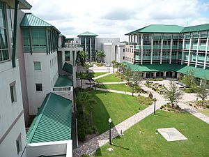
Lee County has several colleges. These include Florida Gulf Coast University (FGCU), Barry University, Nova Southeastern University, and Florida SouthWestern State College. There are also technical colleges like Cape Coral Technical College.
FGCU is a public university located south of the Southwest Florida International Airport. It is part of the State University System of Florida. FGCU teams, called the Eagles, play in NCAA Division I sports. The university offers many different types of degrees.
Parks and Recreation
The parks in Lee County are managed by the county's Parks & Recreation Department. This department also takes care of the spring training facilities for the Boston Red Sox and Minnesota Twins baseball teams.
Beaches
The beaches are a big reason why people visit Southwest Florida. Lee County has ten beach parks and seven other beach access points. These are all taken care of by Lee County Parks & Recreation.
Some popular beaches are Fort Myers Beach, Sanibel and Captiva Island, Bonita Beach, Bunchee Beach, and Lovers Key.
Libraries
The Lee County Library System has 13 branches. The towns of Fort Myers Beach and Sanibel Island have their own public libraries.
The Lee County Library System offers over 1.5 million items for people to use. They also have an online catalog, free Wi-Fi, public computers, and scanning and printing services.
Transportation
Airports
- Southwest Florida International Airport (RSW) is in South Fort Myers. It serves over 8.37 million passengers each year. You can fly directly from here to places like Cancun, Mexico; Frankfurt, Germany; and cities in Canada. Nine airlines fly to 29 different places in the U.S. A new terminal opened at the airport in 2005.
- Page Field (FMY) is also in South Fort Myers. This airport is for general aviation, meaning smaller planes. Before Southwest Florida International Airport opened in 1983, Page Field was the main commercial airport for the county.
Seaports and Boat Travel
A small port still operates in Boca Grande. It is used for oil distribution. However, the port has become less busy over the years. This is because the shipping industry has moved to larger ports further north, like the Port of Tampa.
There is also a private company that runs a fast ferry service. It takes passengers between Fort Myers Beach (from San Carlos Island) and Key West. Another ferry service also goes from Fort Myers to Key West.
Main Roads
| Interstate 75 | This is the only major highway in the county where you can't stop or turn off easily. It has 10 exits in Lee County. It connects the area to Naples, Fort Lauderdale, and Miami to the south and east. It also connects to Sarasota and Tampa to the north. The highway has at least six lanes. | |
| U.S. Route 41 Tamiami Trail Cleveland Avenue |
US 41 runs all the way through Lee County. It is the main north-south road. It is a big road for businesses. It goes through downtown Fort Myers as an elevated highway. Then it continues south as a multi-lane highway through South Fort Myers, Estero, and Bonita Springs. | |
| State Road 80 Palm Beach Boulevard |
SR 80 starts in downtown Fort Myers. This multi-lane highway goes east along the Caloosahatchee River. It connects the area to places like LaBelle and West Palm Beach. | |
| State Road 82 Dr. Martin Luther King Jr. Boulevard Immokalee Road |
SR 82 also starts in downtown Fort Myers. It is called "Dr. Martin Luther King Jr. Boulevard" in Fort Myers. Then it becomes "Immokalee Road" as it goes through Lehigh Acres and connects to Immokalee. | |
| State Road 884 Veterans Memorial Parkway Colonial Boulevard Lee Boulevard |
SR 884 is Lee County's main east-west highway. It starts in Cape Coral and ends in Lehigh Acres. In Cape Coral, it's called "Veterans' Memorial Parkway." In Fort Myers, it's "Colonial Boulevard." It crosses the Caloosahatchee River on a toll bridge. After it crosses State Road 82, it's called "Lee Boulevard." |
Major Road Bridges
- Caloosahatchee Bridge (U.S. Highway 41): This bridge has 4 lanes and connects North Fort Myers with Fort Myers over the Caloosahatchee River.
- Cape Coral Bridge (College Parkway/Cape Coral Parkway): This 4-lane bridge connects Cape Coral with Cypress Lake over the Caloosahatchee River.
- Edison Bridge (State Road 739): This bridge has two parts, each with 3 lanes. It connects North Fort Myers with Fort Myers over the Caloosahatchee River.
- Interstate 75: This highway has two bridges, each with 4 lanes. They cross the Caloosahatchee River between State Road 78 and State Road 80.
- Matanzas Pass Bridge (State Road 865): This 3-lane bridge crosses Hurricane Bay and Matanzas Pass in Fort Myers Beach. It connects the mainland to the barrier islands.
- Midpoint Memorial Bridge (County Road 884): This 4-lane bridge connects Cape Coral with Fort Myers over the Caloosahatchee River.
- Pine Island Causeway (County Road 78): This is a small drawbridge that connects Cape Coral to Matlacha and Pine Island.
- Sanibel Causeway: This is a series of three bridges and two island causeways. They cross the mouth of the Caloosahatchee River where it meets the Gulf of Mexico. The causeway connects Punta Rassa with Sanibel.
- Wilson Pigott Bridge (State Road 31): This is a 2-lane drawbridge between State Road 78 and State Road 80 over the Caloosahatchee River.
Public Transportation
Bus service is provided by Lee County Transit Department, known as "LeeTran". Buses run from the Downtown Intermodal Transfer Center. There are also routes between different suburbs. You can also use park-and-ride services to Fort Myers Beach and Southwest Florida International Airport.
The Downtown Intermodal Transfer Center in Fort Myers is also a stop for Greyhound Lines bus service.
Media
Newspapers
Newspapers in Lee County include The News-Press and Florida Weekly.
Radio
The Fort Myers-Naples-Marco Island area has 32 radio stations.
Television
The Fort Myers-Naples area has many TV channels:
- WBBH – NBC channel
- WFTX – Fox channel
- WGCU – PBS channel
- WINK – CBS channel
- WINK-DT2 – MyNetworkTV/Antenna TV channel
- WRXY - Christian Television Network channel
- WTPH – Azteca America channel
- WUVF - Univision channel
- WWDT - Telemundo channel
- WXCW – CW television network channel
- WZVN – ABC channel
Sports
| Club | Sport | League | Tier | Venue (capacity) |
|---|---|---|---|---|
| Florida Everblades | Ice hockey | ECHL | Mid-level | Hertz Arena, Estero (7,181) |
| Fort Myers Mighty Mussels | Baseball | Florida State League | Class A | Hammond Stadium, S. Fort Myers (7,500) |
| Boston Red Sox | Baseball | Major League Baseball | Spring training | JetBlue Park at Fenway South, Fort Myers (11,000) |
| Minnesota Twins | Baseball | Major League Baseball | Spring training | Hammond Stadium, S. Fort Myers (7,500) |
| Florida Gulf Coast Eagles | Basketball | ASUN Conference | Division I (NCAA) | Alico Arena, Fort Myers (4,500) |
Fort Myers is home to Florida Gulf Coast University. Their sports teams, the Florida Gulf Coast Eagles, play in NCAA Division I.
MLB Spring Training
The Boston Red Sox baseball team holds their yearly spring training at JetBlue Park at Fenway South in Fort Myers. The Minnesota Twins also have their spring training nearby at Hammond Stadium. This stadium can hold 7,500 fans and opened in 1991.
JetBlue Park opened for the 2012 season. Before that, the Red Sox used City of Palms Park, which was built in 1992. Mike Greenwell, a former Red Sox player from Fort Myers, helped bring his team to the city for spring training.
Communities
Cities
Town
Village
Municipal District
Census-Designated Places (CDPs)
- Alva
- Bokeelia
- Buckingham
- Burnt Store Marina
- Captiva
- Charleston Park
- Cypress Lake
- Florida Gulf Coast University
- Fort Myers Shores
- Gateway
- Harlem Heights
- Iona
- Lochmoor Waterway Estates
- Matlacha (on Matlacha Island)
- Matlacha Isles-Matlacha Shores
- McGregor
- North Fort Myers
- Olga
- Page Park
- Palmona Park
- Pine Island Center
- Pine Manor
- Pineland (on Pine Island)
- Punta Rassa
- San Carlos Park
- St. James City
- Suncoast Estates
- Three Oaks
- Tice
- Verandah
- Villas
- Whiskey Creek
Other Unincorporated Communities
See also
 In Spanish: Condado de Lee (Florida) para niños
 | John T. Biggers |
 | Thomas Blackshear |
 | Mark Bradford |
 | Beverly Buchanan |


