Marco Island, Florida facts for kids
Quick facts for kids
Marco Island, Florida
|
|
|---|---|
| City of Marco Island | |
 |
|
| Nickname(s):
La Isla de San Marco
|
|

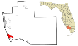
Location in Collier County and the state of Florida
|
|
| Country | United States |
| State | Florida |
| County | Collier |
| Area | |
| • Total | 24.66 sq mi (63.88 km2) |
| • Land | 12.16 sq mi (31.49 km2) |
| • Water | 12.51 sq mi (32.39 km2) |
| Elevation | 10 ft (3 m) |
| Population
(2020)
|
|
| • Total | 15,760 |
| • Density | 1,296.37/sq mi (500.52/km2) |
| Time zone | UTC-5 (Eastern (EST)) |
| • Summer (DST) | UTC-4 (EDT) |
| ZIP Codes |
34145–34146
|
| Area code(s) | 239 |
| FIPS code | 12-43083 |
| GNIS feature ID | 0286403 |
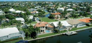
Marco Island is a city and a barrier island in Florida. It's located in Collier County, about 20 miles south of Naples. This island is on the Gulf Coast of the United States. It's the biggest barrier island in Southwest Florida's Ten Thousand Islands area. This area stretches south all the way to Cape Sable. Marco Island is known for its beautiful beaches and fun resorts.
You can reach the island by road using two bridges: the Collier Boulevard bridge and the San Marco Road bridge (CR 92).
The island has several places where you can enjoy the beach. There are two public beaches with parking and facilities: Tigertail Beach and South Beach. Residents also have a private beach complex called Residents' Beach. You can also find other public access points, though they don't have many facilities. Other islands nearby, like Keewaydin, can be reached by boat or tour.
Marco Island is a main city in the Naples–Marco Island Metropolitan Area. In 2020, about 15,760 people lived here. This number more than doubles during the winter months when many visitors arrive.
Some parts of the island are higher than the usual flat land in South Florida. The island has a tropical climate. This means it has clear wet and dry seasons. Most of the rain falls between June and October.
Contents
Marco Island's Past
The history of Marco Island goes back to 500 CE. At that time, the Calusa people lived on the island and throughout southwest Florida. In 1896, an expert named Frank Hamilton Cushing found many Calusa artifacts on Key Marco. Key Marco was a separate island back then, but it's now connected to Marco Island.
One of the most famous things found was the carved wooden "Key Marco Cat." You can see it today at the Marco Island Historical Museum. It's on loan from the Smithsonian Institution. This artifact was even featured on a postage stamp in 1989.
When Spanish explorers arrived in the mid-1500s, they named the island La Isla de San Marcos. This name honors St. Mark, who is believed to have written the Gospel of Mark.
The island began to develop in the late 1800s. This happened after William Thomas Collier and his family arrived. Collier started the village of Marco on the island in 1870. In 1896, his son, William D. "Capt. Bill" Collier, opened a hotel. Today, this hotel is known as the Olde Marco Inn.
In the early 1900s, clam digging became a big business on Marco Island. The Burnham Clam Cannery started in 1903 and operated until 1929. The Doxsee Clam Cannery also ran from 1911 to 1947.
Ferry service started in 1912, connecting Marco Island to the Isles of Capri. A road on the mainland linked the ferry to East Naples. A small part of this old road is still there and is called Barefoot Williams Road.
In 1922, Barron G. Collier bought a lot of land on Marco Island. Collier County is named after him, but he was not related to William T. Collier. In 1927, the island became a city called Collier City. Collier City stopped being a city in 1957. James Harvey Doxsee Sr. was its only mayor.
Also in 1927, the Atlantic Coast Line Railroad started train service to the island. The railroad extended its route from Fort Myers and Naples. The train tracks followed the path of what is now State Road 951. Train service ended in 1944.
The first bridge for vehicles to the island was a small wooden swing bridge. It was built in 1938 near Goodland on the east side of the island. You can still see parts of this old bridge next to the current one. The current bridge, the Stan Gober Memorial Bridge, was built in 1975. The island's ferry service stopped after the first Goodland Bridge opened.
A lot of new buildings and homes were built on Marco Island in the 1960s. This development turned it into the popular retirement and tourist spot it is today. The Mackle brothers from the Deltona Corporation led this growth. They bought a lot of land for $7 million. Because of this development, the S.S. Jolley Bridge opened in 1969.
Marco Island officially became a city again on August 28, 1997. Like many places on the coast, residents often deal with issues like short-term rentals and traffic.
On September 28, 2022, Hurricane Ian hit the island. It caused a storm surge of 8 feet, which means the ocean water rose very high and flooded parts of the island.
Island Geography
Marco Island is located in the southwestern part of Collier County. It sits right along the Gulf of Mexico.
The city covers an area of about 24.66 square miles (63.88 square kilometers). About 12.16 square miles (31.49 square kilometers) of this is land. The rest, about 12.51 square miles (32.39 square kilometers), is water.
Marco Island's Climate
Marco Island has a tropical climate. This means it's warm all year round. The average temperature in January, the coldest month, is about 64.4°F (18°C).
| Climate data for Marco Island, Florida, 1991–2020 normals, extremes 2002–present | |||||||||||||
|---|---|---|---|---|---|---|---|---|---|---|---|---|---|
| Month | Jan | Feb | Mar | Apr | May | Jun | Jul | Aug | Sep | Oct | Nov | Dec | Year |
| Record high °F (°C) | 86 (30) |
87 (31) |
88 (31) |
93 (34) |
95 (35) |
97 (36) |
98 (37) |
97 (36) |
96 (36) |
94 (34) |
92 (33) |
87 (31) |
98 (37) |
| Mean maximum °F (°C) | 81.7 (27.6) |
82.1 (27.8) |
84.0 (28.9) |
88.3 (31.3) |
91.5 (33.1) |
94.1 (34.5) |
94.1 (34.5) |
94.3 (34.6) |
93.3 (34.1) |
90.9 (32.7) |
86.8 (30.4) |
83.5 (28.6) |
95.1 (35.1) |
| Mean daily maximum °F (°C) | 73.9 (23.3) |
76.2 (24.6) |
78.9 (26.1) |
83.2 (28.4) |
87.5 (30.8) |
90.1 (32.3) |
91.1 (32.8) |
91.5 (33.1) |
90.0 (32.2) |
86.9 (30.5) |
80.5 (26.9) |
76.8 (24.9) |
83.9 (28.8) |
| Daily mean °F (°C) | 64.4 (18.0) |
66.7 (19.3) |
69.4 (20.8) |
74.1 (23.4) |
78.6 (25.9) |
82.2 (27.9) |
83.5 (28.6) |
83.8 (28.8) |
82.6 (28.1) |
78.8 (26.0) |
72.0 (22.2) |
67.7 (19.8) |
75.3 (24.1) |
| Mean daily minimum °F (°C) | 54.9 (12.7) |
57.1 (13.9) |
59.9 (15.5) |
64.9 (18.3) |
69.7 (20.9) |
74.2 (23.4) |
75.8 (24.3) |
76.2 (24.6) |
75.2 (24.0) |
70.7 (21.5) |
63.4 (17.4) |
58.6 (14.8) |
66.7 (19.3) |
| Mean minimum °F (°C) | 39.0 (3.9) |
42.5 (5.8) |
46.7 (8.2) |
55.3 (12.9) |
62.5 (16.9) |
70.0 (21.1) |
72.3 (22.4) |
72.0 (22.2) |
71.5 (21.9) |
59.5 (15.3) |
49.9 (9.9) |
45.9 (7.7) |
36.9 (2.7) |
| Record low °F (°C) | 28 (−2) |
31 (−1) |
39 (4) |
47 (8) |
58 (14) |
66 (19) |
69 (21) |
67 (19) |
65 (18) |
45 (7) |
42 (6) |
32 (0) |
28 (−2) |
| Average precipitation inches (mm) | 2.50 (64) |
1.91 (49) |
2.05 (52) |
2.48 (63) |
3.38 (86) |
8.36 (212) |
6.60 (168) |
9.16 (233) |
9.92 (252) |
3.21 (82) |
2.02 (51) |
1.71 (43) |
53.30 (1,354) |
| Average precipitation days (≥ 0.01 in) | 5.3 | 4.7 | 4.3 | 5.0 | 8.7 | 15.9 | 15.8 | 18.8 | 17.5 | 8.6 | 5.4 | 5.1 | 115.1 |
| Source: NOAA (mean maxima/minima 2006–2020) | |||||||||||||
Island Population
| Historical population | |||
|---|---|---|---|
| Census | Pop. | %± | |
| 1980 | 4,694 | — | |
| 1990 | 9,493 | 102.2% | |
| 2000 | 14,879 | 56.7% | |
| 2010 | 16,413 | 10.3% | |
| 2020 | 15,760 | −4.0% | |
| U.S. Decennial Census | |||
In 2020, about 15,760 people lived in Marco Island. There were 9,056 households and 6,109 families.
In 2010, there were 7,517 households. About 9.4% of these households had children under 18 living with them. Also, 46.7% of households had people aged 65 or older. The average household size was 2.21 people.
In 2010, the average income for a household in the city was $73,373. The income per person was $52,089. About 2.1% of the people lived below the poverty level.
Schools on Marco Island
The District School Board of Collier County manages the public schools that serve Marco Island. These include:
- Lely High School
- Marco Island Academy High School
- Marco Island Charter Middle School
- Tommie Barfield Elementary School
There are also private schools on the island:
- Island Montessori Academy
- Marketplace Mission Learning Center
Getting Around Marco Island
Marco Island Executive Airport (MRK) is a small airport for private planes. It's about 4 miles northeast of the island's main business area. For bigger commercial flights, the closest airport is Southwest Florida International Airport.
You can also use public transportation on Marco Island. Collier Area Transit has Route #21 and an express route, #121, which goes from Immokalee to Marco Island.
Famous People from Marco Island
Some well-known people have lived in Marco Island:
- John Boehner, who used to be the Speaker of the United States House of Representatives
- Michael Collins, an astronaut
- William J. Cullerton, a World War II flying ace
- Leighton Meester, an actress
See also
 In Spanish: Marco Island para niños
 | DeHart Hubbard |
 | Wilma Rudolph |
 | Jesse Owens |
 | Jackie Joyner-Kersee |
 | Major Taylor |

