Matlacha, Florida facts for kids
Quick facts for kids
Matlacha, Florida
|
|
|---|---|
 |
|

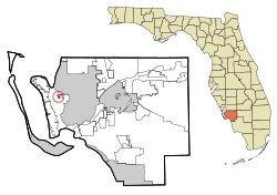
Location in Lee County and the state of Florida
|
|
| Country | United States |
| State | |
| County | Lee |
| Area | |
| • Total | 0.67 sq mi (1.73 km2) |
| • Land | 0.20 sq mi (0.51 km2) |
| • Water | 0.47 sq mi (1.21 km2) |
| Elevation | 1 ft (0.3 m) |
| Population
(2020)
|
|
| • Total | 598 |
| • Density | 3,005.03/sq mi (1,163.16/km2) |
| Time zone | UTC-5 (Eastern (EST)) |
| • Summer (DST) | UTC-4 (EDT) |
| ZIP code |
33993
|
| Area code(s) | 239 |
| FIPS code | 12-43475 |
| GNIS feature ID | 0286522 |
Matlacha (pronounced "MAT-la-shay") is a small community in Lee County, Florida, United States. It's known as a census-designated place (CDP). This means it's an area that looks like a town but isn't officially governed as one.
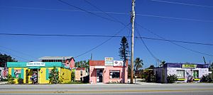
In 2020, about 598 people lived in Matlacha. It's part of the larger Cape Coral-Fort Myers, Florida Metropolitan Statistical Area. Matlacha is famous for being an "Old Florida" fishing village. It has many colorful art galleries, unique island shops, and seafood restaurants. You can also find traditional Florida-style cottages here. Sadly, a big storm called Hurricane Ian caused a lot of damage to the village in October 2022.
Contents
Matlacha's Location
Matlacha is located in the northwest part of Lee County. It sits on West Island and Porpoise Point Island. This area is a narrow spot in Matlacha Pass. This pass is a waterway that separates Pine Island from the mainland.
A road called County Road 78 (Southwest Pine Island Road) crosses the water at Matlacha. This road goes southwest about 3 miles to Pine Island Center. It also goes northeast through Cape Coral for about 12 miles to North Fort Myers. Matlacha Isles-Matlacha Shores is another community nearby, just across Matlacha Pass to the northeast.
Land and Water Area
The United States Census Bureau measures the size of places like Matlacha. They found that Matlacha has a total area of about 1.78 square kilometers (0.67 square miles). Most of this area is water! About 0.52 square kilometers (0.20 square miles) is land. The rest, about 1.26 square kilometers (0.47 square miles), is water. This means about 71% of Matlacha's total area is water.
Who Lives in Matlacha?
| Historical population | |||
|---|---|---|---|
| Census | Pop. | %± | |
| 2000 | 735 | — | |
| 2010 | 677 | −7.9% | |
| 2020 | 598 | −11.7% | |
| U.S. Decennial Census | |||
The number of people living in Matlacha has changed over the years. In 2000, there were 735 people. By 2010, the population went down to 677. In 2020, it decreased again to 598 people.
Most people in Matlacha are White. In 2000, about 98% of the people were White. A small number of people were Native American or Asian. In 2010, the number of African-American residents increased slightly.
Households and Families
In 2000, there were 409 households in Matlacha. A household is a group of people living together. About 6.4% of these households had children under 18. Nearly half (46.9%) were married couples living together. Many households (39.4%) were made up of people living alone. About 19.3% of households had someone living alone who was 65 or older.
The average household had 1.80 people. The average family had 2.33 people.
Age Groups
The population in Matlacha is spread out across different age groups. In 2000:
- 7.3% of people were under 18 years old.
- 2.4% were between 18 and 24 years old.
- 17.4% were between 25 and 44 years old.
- 34.7% were between 45 and 64 years old.
- 38.1% were 65 years old or older.
The median age in Matlacha was 58 years. This means half the people were younger than 58, and half were older. For every 100 females, there were about 106 males.
Income Information
In 2000, the median income for a household in Matlacha was $36,417. The median income for a family was $50,000. This means half the households earned more than $36,417, and half earned less. The average income per person in Matlacha was $24,371.
See also
 In Spanish: Matlacha para niños
 | Lonnie Johnson |
 | Granville Woods |
 | Lewis Howard Latimer |
 | James West |

