Immokalee, Florida facts for kids
Quick facts for kids
Immokalee, Florida
|
|
|---|---|

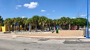
Immokalee Zocalo Public Plaza
|
|
| Etymology: Mikasuki: Immokalee (your home) | |

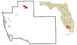
Location in Collier County and the state of Florida
|
|
| Country | United States |
| State | Florida |
| County | Collier |
| Area | |
| • Total | 23.29 sq mi (60.32 km2) |
| • Land | 22.72 sq mi (58.85 km2) |
| • Water | 0.57 sq mi (1.48 km2) 2.5% |
| Elevation | 33 ft (10 m) |
| Population
(2020)
|
|
| • Total | 24,557 |
| • Density | 1,080.81/sq mi (417.30/km2) |
| Time zone | UTC-5 (Eastern (EST)) |
| • Summer (DST) | UTC-4 (EDT) |
| ZIP codes |
34142–34143
|
| Area code(s) | 239 |
| FIPS code | 12-33250 |
| GNIS feature ID | 284474 |
Immokalee is a community in Collier County, Florida, in the United States. It's not an official city, but a "census-designated place." This means it's a community that the government counts for population surveys.
The name Immokalee comes from the Mikasuki language, and it means "your home." In 2020, about 24,557 people lived there. Immokalee is part of the larger Naples–Marco Island area.
Contents
A Look Back in Time: Immokalee's History
Long ago, the Calusa people lived in this area. Centuries later, the Seminole people moved here from northern Florida. They first called the settlement Gopher Ridge. The name Immokalee, meaning "your home," came from the Miccosukee and Seminole nations.
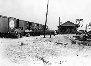
In 1872, the first permanent settlement was started. When the swamps were drained, farming became very important. Hunters, traders, and missionaries also moved into the area. A railroad line reached Immokalee in 1921, helping to transport goods. This railroad was removed in 1989.
Immokalee is a major farming area, especially known for growing tomatoes. The hard work of the farm workers in this region has been highlighted in important reports over the years.
Where is Immokalee?
Immokalee is located in the northern part of Collier County. It's found along Florida State Road 29. The town of LaBelle is about 24 miles (39 km) north. Interstate 75, also known as Alligator Alley, is about 20 miles (32 km) south.
The community covers an area of about 23.3 square miles (60.3 square kilometers). Most of this area is land, with a small part being water.
Immokalee's Weather
Immokalee has a warm climate. It's almost a tropical climate, which means it's warm all year round. Even in January, the coldest month, the average temperature is around 63.9°F (17.7°C). Summers are hot and humid, while winters are mild and dry.
People of Immokalee
| Historical population | |||
|---|---|---|---|
| Census | Pop. | %± | |
| 1960 | 3,224 | — | |
| 1970 | 3,764 | 16.7% | |
| 1980 | 11,038 | 193.3% | |
| 1990 | 14,120 | 27.9% | |
| 2000 | 19,763 | 40.0% | |
| 2010 | 24,154 | 22.2% | |
| 2020 | 24,557 | 1.7% | |
| source: | |||
In 2020, Immokalee had a population of 24,557 people. There were about 5,985 households living in the area.
The community is very diverse. A large part of the population, about 75.53%, is of Hispanic or Latino background. About 19.85% of the population is Black or African American.
Culture and Fun in Immokalee
The Seminole Tribe of Florida has one of its six special areas, called reservations, in Immokalee. On this reservation, they operate a gaming casino.
Close by, you can visit the Audubon Society's Corkscrew Swamp Sanctuary. This is a beautiful natural area where you can see amazing wildlife and old-growth cypress trees.
Schools and Learning
Public schools in Immokalee are managed by the District School Board of Collier County.
- Elementary Schools: Kids in Immokalee can attend Eden Park, Highlands, Lake Trafford, and Village Oaks Elementary Schools. Pinecrest Elementary also serves some parts of the community.
- Middle and High Schools: All students in Immokalee go to Immokalee Middle School and Immokalee High School.
Media and Radio Stations
Immokalee has its own local radio stations.
- WCIW-LP: This is a special low-power community radio station. It's run by the Coalition of Immokalee Workers. Volunteers from Immokalee and other places helped build it. WCIW plays music, news, and public affairs programs. You can hear broadcasts in Spanish, Haitian Creole, and several indigenous languages.
- WAFZ-FM (92.1 FM): This station plays popular Regional Mexican music hits. It used to play Tejano music too. WAFZ's programs can also be heard on WAFZ AM 1490.
Getting Around Immokalee
Immokalee has several ways to get around.
- Bus Service: Collier Area Transit offers local bus service. Bus #5 goes to Naples, and bus #7 goes to Marco Island (though with fewer trips). Bus 8A travels within the Immokalee area.
- Roads: The main road is Florida State Road 29. Other important roads include CR 29A and CR 846.
- Airport: For smaller planes, there's Immokalee Airport. It's a public airport about 1 mile (1.6 km) northeast of the town center. For bigger commercial flights, the closest airport is Southwest Florida International Airport.
Famous People from Immokalee
Many talented people have come from Immokalee, especially in sports!
- Mackensie Alexander – A cornerback in football.
- Albert Bentley – Played football for the Miami Hurricanes and the Indianapolis Colts.
- J. C. Jackson – A cornerback for the Los Angeles Chargers.
- Edgerrin James – A Hall of Fame running back, famous for playing with the Indianapolis Colts.
- Javarris James – A running back for the Indianapolis Colts.
- D'Ernest Johnson – A running back for the Jacksonville Jaguars.
- Brian Rolle – A former linebacker in the NFL and CFL.
- Ovince Saint Preux – A competitor in the Ultimate Fighting Championship.
- Deadrin Senat – A defensive tackle in football.
See also
 In Spanish: Immokalee para niños
 | Aurelia Browder |
 | Nannie Helen Burroughs |
 | Michelle Alexander |


