Monroe County, Florida facts for kids
Quick facts for kids
Monroe County
|
|||
|---|---|---|---|

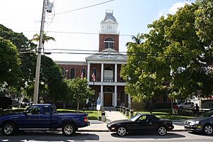
The Monroe County Courthouse in Key West
|
|||
|
|||

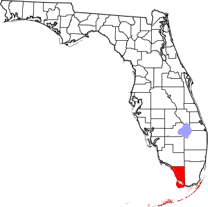
Location within the U.S. state of Florida
|
|||
 Florida's location within the U.S. |
|||
| Country | |||
| State | |||
| Founded | July 3, 1823 | ||
| Named for | James Monroe | ||
| Seat | Key West | ||
| Largest city | Key West | ||
| Area | |||
| • Total | 3,738 sq mi (9,680 km2) | ||
| • Land | 983 sq mi (2,550 km2) | ||
| • Water | 2,754 sq mi (7,130 km2) 73.7%% | ||
| Population
(2020)
|
|||
| • Total | 82,874 | ||
| • Estimate
(2023)
|
80,614 |
||
| • Density | 22.1707/sq mi (8.5601/km2) | ||
| Time zone | UTC−5 (Eastern) | ||
| • Summer (DST) | UTC−4 (EDT) | ||
| Congressional district | 28th | ||
Monroe County is the southernmost county in the state of Florida. In 2020, about 82,874 people lived there. The main city and government center is Key West.
Monroe County includes the beautiful islands of the Florida Keys. It is also part of the Key West-Key Largo Micropolitan Statistical Area. Almost everyone in the county lives on the Florida Keys. The mainland part of the county is mostly empty. It is part of the Everglades and has very few people.
Contents
History
Monroe County was created in 1823. It was named after James Monroe. He was the fifth president of the United States. He served as president from 1817 to 1825.
Geography
Monroe County is very large. It covers about 3,738 square miles (9,681 square kilometers). Most of this area, about 73.7%, is water. The land area is about 983 square miles (2,546 square kilometers). This makes it the biggest county in Florida by total area.
The Florida Keys
More than 99.9% of the people in Monroe County live on the Florida Keys. This is a chain of islands that stretches into the ocean.
Mainland Monroe
A big part of Monroe County is on the Florida mainland. This area is mostly empty. It is part of the Everglades National Park and the Big Cypress National Preserve. Only a few people live here.
The mainland area is called Cape Sable Census County Division. It makes up 87.4% of the county's land. But in 2021, only about 18 people lived there.
Places on the Mainland
There are only a few small places with people on the mainland.
- Flamingo is on the south coast. It has a lodge, a ranger station, and a visitor center.
- Pinecrest is in the northern part. It has an education center.
- Trail City is a few miles west of Pinecrest.
Between the Florida mainland and the Keys is Florida Bay. This bay is part of the Everglades National Park. It has many small islands.
Key West-Key Largo Area
Monroe County is also known as the Key West-Key Largo Micropolitan Statistical Area. This means it's a small city area with strong ties to Key Largo and Key West. This area is part of the larger Miami-Port Saint Lucie-Fort Lauderdale Combined Statistical Area.
Neighboring Counties
Monroe County shares borders with two other counties:
- Collier County is to the north on the mainland.
- Miami-Dade County is to the east on the mainland and north over water.
Protected Natural Areas
Monroe County is home to many important natural places. These areas protect wildlife and beautiful landscapes.
- Bahia Honda State Park
- Big Cypress National Preserve
- Crocodile Lake National Wildlife Refuge
- Curry Hammock State Park
- Dagny Johnson Key Largo Hammock Botanical State Park
- Dry Tortugas National Park
- Everglades National Park
- Fort Zachary Taylor Historic State Park
- Great White Heron National Wildlife Refuge
- Indian Key State Historic Site
- John Pennekamp Coral Reef State Park
- Key West National Wildlife Refuge
- Lignumvitae Key Botanical State Park
- Long Key State Park
- National Key Deer Refuge
- San Pedro Underwater Archaeological Preserve State Park
- Windley Key Fossil Reef Geological State Park
Population and People
| Historical population | |||
|---|---|---|---|
| Census | Pop. | %± | |
| 1830 | 517 | — | |
| 1840 | 688 | 33.1% | |
| 1850 | 2,645 | 284.4% | |
| 1860 | 2,913 | 10.1% | |
| 1870 | 5,657 | 94.2% | |
| 1880 | 10,940 | 93.4% | |
| 1890 | 18,786 | 71.7% | |
| 1900 | 18,006 | −4.2% | |
| 1910 | 21,563 | 19.8% | |
| 1920 | 19,550 | −9.3% | |
| 1930 | 13,624 | −30.3% | |
| 1940 | 14,078 | 3.3% | |
| 1950 | 29,957 | 112.8% | |
| 1960 | 47,921 | 60.0% | |
| 1970 | 52,586 | 9.7% | |
| 1980 | 63,188 | 20.2% | |
| 1990 | 78,024 | 23.5% | |
| 2000 | 79,589 | 2.0% | |
| 2010 | 73,090 | −8.2% | |
| 2020 | 82,874 | 13.4% | |
| 2023 (est.) | 80,614 | 10.3% | |
| U.S. Decennial Census 1790–1960 1900–1990 1990–2000 2010–2019 2020 |
|||
Population in 2020
In 2020, Monroe County had 82,874 people. There were 32,839 households and 18,586 families.
| Race | Number | Percentage |
|---|---|---|
| White (not Hispanic) | 54,731 | 66.04% |
| Black or African American (not Hispanic) | 4,517 | 5.45% |
| Native American | 169 | 0.2% |
| Asian | 1,137 | 1.37% |
| Pacific Islander | 61 | 0.07% |
| Other/Mixed | 2,827 | 3.41% |
| Hispanic or Latino | 19,432 | 23.45% |
Languages Spoken
In 2010, most people in Monroe County spoke only English at home (77.57%). Spanish was spoken by 17.56% of people. Other languages like French Creole, French, and Russian were also spoken. Overall, about 22.43% of people spoke a language other than English at home.
Transportation
Airports
- Key West International Airport
- Florida Keys Marathon Airport
Main Roads

 US 1 / SR 5 (Overseas Highway)
 SR A1A (Roosevelt Boulevard)
 CR 905 (Key Largo Drive)
 CR 905A (Card Sound Road)
Culture
Monroe County has many cultural groups and places. These include the Key West Literary Seminar and The Studios of Key West. There are also theaters like the Red Barn Theatre and the Key West Symphony. You can visit the Hemingway House and Museum or the Customs House Museum.
The Florida Keys Council for the Arts helps support arts and culture. It gives money to artists and groups. It also helps promote cultural tourism in the area. The council works to make arts a part of daily life for everyone.
Education
The Monroe County School District runs all the public schools. There are also several private schools.
Florida Keys Community College is the main college. It has its main campus in Key West. It also has campuses in Marathon and Key Largo.
Economy
More than half of the jobs in Monroe County are in the tourism industry. In 2016, tourism brought in $2.7 billion for the county. This shows how important visitors are to the local economy.
Communities
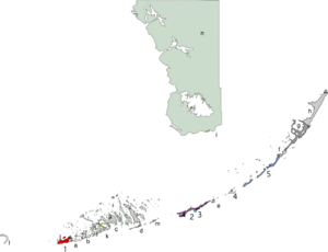
Cities
- Key West (1)
- Marathon (2)
- Key Colony Beach (3)
- Layton (4)
Village
- Islamorada (5)
Census-Designated Places (CDPs)
These are areas that are like towns but are not officially incorporated as cities.
- Stock Island (a)
- Big Coppitt Key (b)
- Cudjoe Key (c)
- Big Pine Key (d)
- Duck Key (e)
- Tavernier (f)
- Key Largo (g)
- North Key Largo (h)
Other Unincorporated Areas
These are areas that are not part of any city or village.
- Flamingo (i)
- Bay Point (j)
- Sugarloaf Shores (k)
- Marquesas Keys (l)
- Bahia Honda Key (m)
- Everglades (n)
Former Communities
These places used to be communities but are no longer active or recognized as such.
- Chevelier
- Craig
- Fort Jefferson
- Indian Key
- Perky
- Poinciana
- Pigeon Key
- Pinecrest
- Snake Bight
See also
 In Spanish: Condado de Monroe (Florida) para niños
 | William L. Dawson |
 | W. E. B. Du Bois |
 | Harry Belafonte |


