Key Colony Beach, Florida facts for kids
Quick facts for kids
Key Colony Beach, Florida
|
|
|---|---|
| City of Key Colony Beach | |

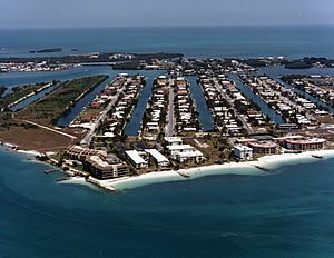
Aerial view of Key Colony Beach, October 1987
|
|
| Motto(s):
"Gem of the Florida Keys"
|
|

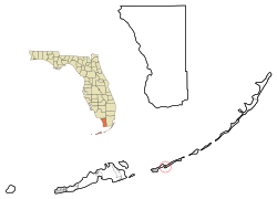
Location in Monroe County and the state of Florida
|
|

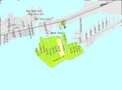
U.S. Census Bureau map showing city limits
|
|
| Country | |
| State | |
| County | Monroe |
| Incorporated | 1957 |
| Government | |
| • Type | Mayor-Commission |
| Area | |
| • Total | 0.65 sq mi (1.68 km2) |
| • Land | 0.44 sq mi (1.14 km2) |
| • Water | 0.21 sq mi (0.54 km2) |
| Elevation | 3 ft (1 m) |
| Population
(2020)
|
|
| • Total | 790 |
| • Density | 1,795.45/sq mi (693.21/km2) |
| Time zone | UTC-5 (Eastern (EST)) |
| • Summer (DST) | UTC-4 (EDT) |
| ZIP Code |
33051
|
| Area code(s) | 305 |
| FIPS code | 12-36325 |
| GNIS feature ID | 0285076 |
Key Colony Beach is a small city located in the middle of the beautiful Florida Keys. It is part of Monroe County, Florida, in the United States. In 2020, about 790 people lived there.
Contents
History of Key Colony Beach
Before the 1950s, the land where Key Colony Beach now stands was mostly a low-lying island called Shelter Key. It was about 97 acres in size.
A person named Phil Sadowski started to change the island. He used a process called dredging to add more land and make the island higher. He raised it to about 6 feet above sea level. After that, he began building homes and other developments on the island.
Around 1956 and 1957, people in nearby Marathon wanted to make their whole area into one city. However, Phil Sadowski did not want his new development to become part of Marathon. So, he started the process to make Shelter Key its own city.
In June 1957, the Florida Legislature (the state's law-making group) passed a law allowing this. In September, the people living on the island voted, and everyone agreed to create their own city. This is how Key Colony Beach became a city.
How Key Colony Beach Rebuilt After a Hurricane
Being its own city turned out to be very helpful in 1960. That year, a strong storm called Hurricane Donna hit the area and destroyed much of Key Colony Beach.
Because Key Colony Beach was a separate city, it received its own special money from the government to rebuild. Nearby Marathon, which was not yet a city, had to share money given to the whole county. This shows how important it was for Key Colony Beach to be its own city.
However, the hurricane, and later changes in Cuba, made land prices drop. It took several years for prices to become normal again.
Geography and Location
Key Colony Beach is located at 24°43′28″N 81°1′5″W. Most of the city is on the island that used to be called Shelter Key. A small part of the city is on Fat Deer Key.
The Sadowski Causeway is the only road that leads into Key Colony Beach. This causeway connects the city to U.S. 1, also known as the Overseas Highway. It also connects to the city of Marathon on the east side. Marathon is located to the northwest, north, and northeast of Key Colony Beach. The Atlantic Ocean is to the south.
Exploring Key Colony Beach's Landmarks
Along the Sadowski Causeway, you can find some boats for charter fishing and a restaurant called Sparky's Landing. At the end of the causeway, the road splits into West Ocean Drive and East Ocean Drive.
On West Ocean Drive, you will find the police station, the post office, and the city hall. There is also a small park with a fountain and a gazebo nearby. Many condominium buildings line the side of West Ocean Drive that faces the ocean. The side facing Marathon has the Key Colony Inn and a small golf course.
On East Ocean Drive, the streets are numbered from one to fifteen, going from east to west. These streets run from south to north towards Shelter Bay. The Key Colony Beach Motel and the Key Colony Beach Club are important buildings on East Ocean Drive. At the very end of West Ocean Drive is Sunset Park.
The city covers a total area of about 0.65 square miles (1.68 square kilometers). About 0.44 square miles (1.14 square kilometers) of this is land, and 0.21 square miles (0.54 square kilometers) is water. This means about 32.20% of the city's area is water.
Climate in Key Colony Beach
Key Colony Beach has a tropical climate. This type of climate is similar to what you would find in many parts of the Caribbean. It is one of the only places in the 48 connected states that has this kind of weather.
More specifically, it usually has a tropical savanna climate. This means it has warm temperatures all year and a wet season and a dry season. It is also very close to having a tropical monsoon climate, which means it gets a lot of rain during its wet season.
Population and People
| Historical population | |||
|---|---|---|---|
| Census | Pop. | %± | |
| 1960 | 66 | — | |
| 1970 | 371 | 462.1% | |
| 1980 | 977 | 163.3% | |
| 1990 | 977 | 0.0% | |
| 2000 | 788 | −19.3% | |
| 2010 | 797 | 1.1% | |
| 2020 | 790 | −0.9% | |
| U.S. Decennial Census | |||
Key Colony Beach Census Data
According to the 2020 United States census, 790 people lived in Key Colony Beach. There were 321 households and 180 families living in the city.
In the 2010 United States census, there were 797 people living in the city. At that time, there were 336 households and 202 families.
Education for Students
Key Colony Beach is part of the Monroe County School District. Students in Key Colony Beach attend Stanley Switik Elementary School for grades K-5. For middle and high school (grades 6-12), students go to Marathon High School in Marathon.
Notable People from Key Colony Beach
- Charley Lau, a famous baseball player and coach.
See also
 In Spanish: Key Colony Beach para niños

