Cudjoe Key, Florida facts for kids
Quick facts for kids
Cudjoe Key, Florida
|
|
|---|---|

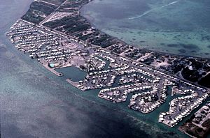
An aerial view of the Venture Out resort, on the southeast side of Cudjoe Key, in 1983
|
|

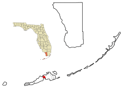
Location in Monroe County and the state of Florida
|
|

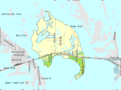
U.S. Census Bureau map showing CDP boundaries
|
|
| Country | |
| State | |
| County | Monroe |
| Area | |
| • Total | 10.45 sq mi (27.07 km2) |
| • Land | 5.17 sq mi (13.40 km2) |
| • Water | 5.28 sq mi (13.67 km2) |
| Elevation | 5 ft (2 m) |
| Population
(2020)
|
|
| • Total | 2,019 |
| • Density | 390.22/sq mi (150.66/km2) |
| Time zone | UTC-5 (Eastern (EST)) |
| • Summer (DST) | UTC-4 (EDT) |
| ZIP code |
33042
|
| Area code(s) | 305 |
| FIPS code | 12-15862 |
| GNIS feature ID | 1867131 |
Cudjoe Key is a small community in Monroe County, Florida, United States. It's located on an island called Cudjoe Key, which is part of the beautiful lower Florida Keys. In 2020, about 2,019 people lived there. This was an increase from 1,763 people in 2010.
Contents
History of Cudjoe Key
What's in a Name?
The island was first called "Littleton Island" in 1772. By 1849, its name changed to "Cudjoe's," which later became "Cudjoe."
The name might come from a tree called the Joewood or Cudjoe wood tree. This tree grows on the island. Another idea is that "Cudjoe" was the name of an escaped slave. This person might have lived on the island in the early 1800s.
Cudjoe Key in the 20th Century
In 1959, the United States Army opened the Cudjoe Key Air Force Station. Its job was to track missiles. These missiles were part of tests from the Eglin Gulf Test Range.
The next year, the Air Force took over the station. It became a smaller part of Homestead Joint Air Reserve Base.
Cudjoe Key in the 21st Century
On September 10, 2017, a very strong storm hit Cudjoe Key. This storm was Hurricane Irma. It was a Category 4 hurricane when it reached the island.
Geography of Cudjoe Key
Cudjoe Key is located in the Florida Keys. You can find it at coordinates 24°39′51″N 81°28′56″W / 24.66417°N 81.48222°W.
The main road, U.S. 1, also known as the Overseas Highway, crosses the island. This highway connects Cudjoe Key to other islands. It's about 20 miles (32 km) west-southwest to Key West. It's also about 30 miles (48 km) east to Marathon. The highway goes all the way to Miami, which is about 136 miles (219 km) northeast.
Cudjoe Key covers about 10.5 square miles (27.2 km²). About half of this area is land, and the other half is water. The water areas include Cudjoe Bay to the south. There's also Kemp Channel to the east. And tidal waters are to the northwest.
Population Facts
| Historical population | |||
|---|---|---|---|
| Census | Pop. | %± | |
| 1990 | 1,714 | — | |
| 2000 | 1,695 | −1.1% | |
| 2010 | 1,763 | 4.0% | |
| 2020 | 2,019 | 14.5% | |
| U.S. Decennial Census | |||
In 2020, the population of Cudjoe Key was 2,019 people. Most of the people living there are White. A small number are African American, Native American, or Asian. Some people are also of Hispanic or Latino background.
In 2000, there were 799 households on the island. About 15.6% of these households had children under 18. The average age of people living in Cudjoe Key was 48 years old.
See also
 In Spanish: Cudjoe Key para niños
 | James Van Der Zee |
 | Alma Thomas |
 | Ellis Wilson |
 | Margaret Taylor-Burroughs |

