Layton, Florida facts for kids
Quick facts for kids
Layton, Florida
|
||
|---|---|---|
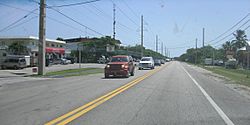
Downtown Layton as seen from US 1 looking south along the road
|
||
|
||
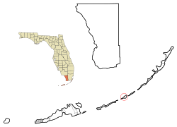
Location in Monroe County and the state of Florida
|
||
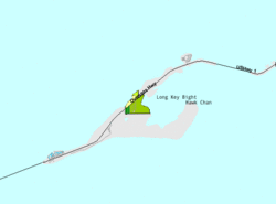
U.S. Census Bureau map showing city limits
|
||
| Country | ||
| State | ||
| County | ||
| Settled (Long Key Settlement) | Late 1800s–1910 | |
| Incorporated (City of Layton) |
September 18, 1963 | |
| Government | ||
| • Type | Mayor-Council | |
| Area | ||
| • Total | 0.22 sq mi (0.58 km2) | |
| • Land | 0.16 sq mi (0.42 km2) | |
| • Water | 0.06 sq mi (0.16 km2) | |
| Elevation | 3 ft (0.9 m) | |
| Population
(2020)
|
||
| • Total | 210 | |
| • Density | 1,296.30/sq mi (499.47/km2) | |
| Time zone | UTC-5 (Eastern (EST)) | |
| • Summer (DST) | UTC-4 (EDT) | |
| ZIP code |
33001
|
|
| Area code(s) | 305 | |
| FIPS code | 12-39725 | |
| GNIS feature ID | 0285408 | |
Layton is a small city found on Long Key, an island in Monroe County, Florida, United States. It's part of the beautiful Florida Keys. In 2020, about 210 people lived there.
Contents
History of Layton
In the late 1800s, Long Key was home to a coconut farm. By 1910, Layton became a popular spot for fishing. This was partly thanks to Zane Grey, a famous writer who wrote about sports.
However, a big storm called the Labor Day Hurricane of 1935 destroyed many tourist buildings. It also ruined the train station on Long Key, which was part of the Overseas Railroad.
After World War II, a couple named Mary and Delbert Layton bought land on Long Key. They started a fishing camp called "Layton's Long Key Fishing Camp." This camp grew a lot over the years.
The City of Layton officially became a city on September 18, 1963. Later, the land that is now Long Key State Park was bought between 1961 and 1973. The park opened to visitors on October 1, 1969.
Geography and Location
Layton is located along U.S. Route 1. This road connects Layton to other places. It is about 66 miles (106 km) northeast of Key West. It is also about 88 miles (142 km) southwest of Miami.
The United States Census Bureau says Layton covers a total area of 0.22 square miles (0.58 km2). Most of this area, 0.16 square miles (0.42 km2), is land. The rest, 0.06 square miles (0.16 km2), is water.
Climate in Layton
Layton has a tropical climate. This is similar to the weather you would find in many parts of the Caribbean. It is one of the few places in the lower 48 states with this type of climate. It usually has a tropical savanna climate, which means it has wet and dry seasons.
Population and People
| Historical population | |||
|---|---|---|---|
| Census | Pop. | %± | |
| 1970 | 100 | — | |
| 1980 | 88 | −12.0% | |
| 1990 | 183 | 108.0% | |
| 2000 | 186 | 1.6% | |
| 2010 | 184 | −1.1% | |
| 2020 | 210 | 14.1% | |
| U.S. Decennial Census | |||
In 2020, there were 210 people living in Layton. These people lived in 55 households, and 28 of these were families. Back in 2010, there were 184 people living in the city.
Languages Spoken
In 2000, most people in Layton, about 90.68%, spoke English as their first language. About 9.31% of the population spoke Spanish as their first language.
Education
All public schools in Layton are part of the Monroe County School District. Students in Layton attend Plantation Key School, which teaches children from kindergarten through 8th grade.
See also
 In Spanish: Layton (Florida) para niños
 | Jessica Watkins |
 | Robert Henry Lawrence Jr. |
 | Mae Jemison |
 | Sian Proctor |
 | Guion Bluford |


