
Tamiami Trail facts for kids
Quick facts for kids Tamiami Trail |
||||
|---|---|---|---|---|
| U.S. Route 41 Historic U.S. Route 94 East Trail |
||||
|
Tamiami Trail highlighted in red
|
||||
| Route information | ||||
| Length | 275 mi (443 km) | |||
| Existed | 1928–present | |||
| Tourist routes |
||||
| Major junctions | ||||
| South end | ||||
|
||||
| North end | ||||
| Highway system | ||||
| Florida State and County Roads Interstate • US • SR (Pre-1945) • Toll • County
|
||||
The Tamiami Trail is a famous road in Florida. It is the southern part of U.S. Highway 41 (US 41). This road stretches about 275 miles (443 km). It goes from Florida State Road 60 (SR 60) in Tampa all the way to US 1 in Miami. A part of this road is also known as State Road 90 (SR 90).
The road has two main sections. The first part runs north to south for about 163 miles (262 km) to Naples. After Naples, it turns into an east-west road. This section crosses the Everglades and forms part of the northern edge of Everglades National Park. In Miami-Dade County, it becomes Southwest 8th Street. This street is famous as Calle Ocho in the Little Havana area of Miami. The trail ends as Southeast 8th Street in Brickell, Downtown Miami.
Contents
History of the Tamiami Trail
The Tamiami Trail has a long and interesting history. It was a huge project to connect Florida's coasts.
Building the Road: Early Days
The idea for a road across Florida started in 1915. People wanted to connect the west and east coasts. It was first called the Miami to Marco Highway. Later, the name "Tamiami Trail" was suggested. This name combines "Tampa" and "Miami."
Work officially began on August 3, 1915. A team surveyed the first 3.5 miles (5.6 km). Lee County faced money problems in 1919. A company called the Chevelier Corporation offered to help. They built a part of the highway through Monroe County. This section is now known as Loop Road.
In 1922, Florida ran out of money for the east-west part. The next year, Barron Collier, a rich businessman, stepped in. He promised to pay for the rest of the Tamiami Trail. In return, a new county would be named after him. This is how Collier County was created in 1923.
Building the east-west section started in 1923. Workers used explosives to create a canal. The dirt from the canal was used to build the road. This was a very difficult task.
Naming the Sections: US 41 and US 94
By 1926, parts of the road were given official U.S. highway numbers. The north-south part became US 41. The east-west part was named US 94. The entire Tamiami Trail officially opened on April 26, 1928. It took 13 years to build and cost $8 million. Workers used 2.6 million sticks of dynamite to clear the way.

US 94 connected Naples to Miami. It was a major engineering success. It was the only way to drive from Naples (and Tampa) to Florida's southeastern coast. In 1949, the US 94 signs were changed to US 41 signs. This made the entire Tamiami Trail part of US 41.
Changes Over Time
Over the years, the Tamiami Trail has seen many changes. In the 1950s, US 41 was extended into downtown Miami and Miami Beach. In 2001, the eastern end of US 41 was shortened in Miami.
Traffic on the Tamiami Trail across the Everglades has decreased. This is because Alligator Alley opened in 1968. Alligator Alley is a faster road to cross Florida. However, urban parts of the Tamiami Trail are often very busy.
In 1968, a huge airport project started west of Miami. It would have made the Tamiami Trail into a large expressway. But environmental groups worried about the Everglades. They stopped the project. Today, one runway from that project is used for flight training.

Plans for Interstate 75 (I-75) also changed. I-75 was supposed to use the Tamiami Trail. But instead, I-75 was routed along Alligator Alley. This helped protect the wildlife, especially the Florida panther.
Today, the Tamiami Trail is a National Scenic Byway. This means it is recognized for its beautiful scenery. You can see the unique landscapes of the Everglades and the Big Cypress National Preserve along the way.
Future Plans for the Tamiami Trail
When the Tamiami Trail was built, people did not fully understand its impact. The road and the Tamiami Canal blocked water flow from Lake Okeechobee to Florida Bay. This has harmed the Everglades, which is often called the "River of Grass."
To help the Everglades, some canals were filled in the 1990s. More culverts (tunnels for water) were built under US 41. These changes help water flow more naturally.
Everglades Restoration Efforts
The United States Army Corps of Engineers has bigger plans. In 2003, they suggested building a 3,000-foot (910 m) causeway (a raised road over water). This "Everglades Skyway" would let more water flow into Everglades National Park. Many environmental groups support this idea.
In December 2009, construction began on a 1-mile (1.6 km) project. This project lifts a part of the road. It helps water flow better into the southern Everglades. In 2010, the U.S. Department of Interior suggested bridging an additional 5.5 miles (8.9 km) of the Tamiami Trail.
In 2013, Florida committed $90 million to raise 2.6 miles (4.2 km) of the road. This will also help natural water drainage into the Everglades. In 2019, a $60 million grant was announced. This grant will help complete the "Tamiami Trail Next Steps" project. It will raise and rebuild the remaining 6.5 miles (10.5 km) of the eastern Tamiami Trail.
As of September 2020, the final steps for the Tamiami Trail project were approved. This work started in November 2020 and should finish by the end of 2024. These efforts will improve water flow in the wetlands. They will also help restore the Tamiami Trail and the Everglades National Park.
Images for kids
-
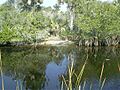
Alligators are a common sight along the scenic Tamiami Trail from Miami to Naples. Unlike its sister Alligator Alley, the trail is only one lane in each direction and has no fences to keep wildlife from traversing it.
-

Tamiami Trail seen toward east in the Big Cypress National Preserve, a few miles north of the Everglades National Park
-

Roadside attractions, sometimes called tourist traps, were a part of the folk character of Tamiami before the interstates. Today, some of these attractions remain, including this greeter/creature at the Skunk-Ape Research Headquarters in Ochopee.
-

A US 41 shield used in Florida prior to 1993


.svg)
- Endpoints of U.S. highways: U.S. Highway 41 and U.S. Highway 94
