Charlotte Harbor, Florida facts for kids
Quick facts for kids
Charlotte Harbor, Florida
|
|
|---|---|

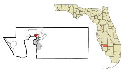
Location in Charlotte County and the state of Florida
|
|
| Country | United States |
| State | Florida |
| County | Charlotte |
| Area | |
| • Total | 5.00 sq mi (12.95 km2) |
| • Land | 2.32 sq mi (6.01 km2) |
| • Water | 2.68 sq mi (6.94 km2) |
| Elevation | 4 ft (1 m) |
| Population
(2020)
|
|
| • Total | 3,784 |
| • Density | 1,631.03/sq mi (629.68/km2) |
| Time zone | UTC-5 (Eastern (EST)) |
| • Summer (DST) | UTC-4 (EDT) |
| Area code(s) | 941 |
| FIPS code | 12-11625 |
| GNIS feature ID | 0280326 |
Charlotte Harbor is a special kind of community in Charlotte County, Florida, United States. It's called a "census-designated place" (CDP), which means it's an area that the government tracks for population and other information, even though it's not officially a city or town.
The name Charlotte Harbor can also mean a few different things:
- The community itself, where people live.
- A large body of water called the Charlotte Harbor estuary. An estuary is where fresh river water mixes with salty ocean water.
- A huge natural area called Charlotte Harbor Preserve State Park. This park is about 42,000 acres (that's like 65 square miles!) and has 70 miles of shoreline along the water. It's a great place to see nature!
In 2020, about 3,784 people lived in Charlotte Harbor. This was a small increase from 3,710 people counted in 2010. Charlotte Harbor is part of a larger area called the Punta Gorda, Florida Metropolitan Statistical Area. This means it's connected to nearby cities and towns for things like jobs and services.
Contents
Where is Charlotte Harbor?
Charlotte Harbor is located in Florida, right on the northern side of the Peace River. The Peace River is a main waterway that flows into the Charlotte Harbor estuary, which then connects to the Gulf of Mexico.
You can find Charlotte Harbor at these coordinates: 26°57′50″N 82°3′44″W.
A major road, U.S. Route 41, also known as the Tamiami Trail, crosses the Peace River here. It uses two bridges: the Barron Collier Bridge for northbound traffic and the Gilchrist Bridge for southbound traffic. These bridges connect Charlotte Harbor to the city of Punta Gorda.
Land and Water Area
The community of Charlotte Harbor covers a total area of about 5.0 square miles (13.0 square kilometers). More than half of this area is water!
- Land area: 2.32 square miles (6.0 square kilometers)
- Water area: 2.68 square miles (7.0 square kilometers), which is about 53.95% of the total area.
How Many People Live Here?
The population of Charlotte Harbor has been growing steadily over the years. Here's a look at how many people have lived there during different census counts:
| Historical population | |||
|---|---|---|---|
| Census | Pop. | %± | |
| 1990 | 3,327 | — | |
| 2000 | 3,647 | 9.6% | |
| 2010 | 3,714 | 1.8% | |
| 2020 | 3,784 | 1.9% | |
| U.S. Decennial Census | |||
A Notable Event: Hurricane Charley
On August 13, 2004, a powerful storm called Hurricane Charley made its first landfall on the mainland right at the mouth of the Charlotte Harbor estuary. This was a significant event for the area.
See also
 In Spanish: Charlotte Harbor para niños
 | Calvin Brent |
 | Walter T. Bailey |
 | Martha Cassell Thompson |
 | Alberta Jeannette Cassell |

