Choctawhatchee Bay facts for kids
Quick facts for kids Choctawhatchee Bay |
|
|---|---|

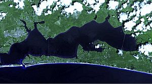
Satellite image of the Choctawhatchee Bay
|
|
| Coordinates | 30°26′22″N 86°18′40″W / 30.43944°N 86.31111°W |
| Primary inflows | Choctawhatchee River |
| Primary outflows | Gulf of Mexico, Santa Rosa Sound |
| Catchment area | 5,405 square miles (14,000 km2) |
| Max. length | 27 miles (43 km) |
| Max. width | 6 miles (9.7 km) |
| Surface area | 129 square miles (330 km2) |
| Max. depth | 43 feet (13 m) |
| Settlements | Fort Walton Beach, Destin Santa Rosa Beach, Freeport, Niceville, Shalimar, Valparaiso |
Choctawhatchee Bay is a large bay located in the Emerald Coast area of Florida. It is found in Okaloosa and Walton counties. The bay covers about 129 square miles (334 square kilometers) of water.
This bay is connected to the Gulf of Mexico through a narrow opening called East Pass. This pass is also known as Destin Pass. It is the only direct way for the bay's water to flow into the Gulf. The bay also links to Santa Rosa Sound in Fort Walton Beach, Florida to the west. To the east, it connects to St. Andrews Bay using the Gulf Intracoastal Waterway.
Many rivers and streams flow into Choctawhatchee Bay. The largest one is the Choctawhatchee River. A bridge called the Mid-Bay Bridge crosses the bay. It connects the city of Destin with Niceville, Florida.
Contents
Bay History

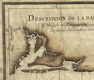
Explorers from Spain, France, and England mapped Choctawhatchee Bay long ago. On some old maps, you might see it called "St. Rose's Bay."
Military Use of the Bay
During World War II, parts of the bay were used for military testing. Eglin Air Force Base set up special areas in the water. These areas had structures with radar reflectors on top. They were used to help test radar systems.
One test area, called D-55, was made of many wooden poles. There were 2,040 poles arranged in 25 groups. These poles were placed in about 8 feet of water. This test area stretched for 1.2 miles.
Cities Around the Bay
Several towns and cities are located right on the shores of Choctawhatchee Bay. These communities enjoy the bay for recreation and its natural beauty.
Waterways Flowing into the Bay
Many rivers, bayous, and lakes contribute water to Choctawhatchee Bay. These are like its arms, bringing fresh water from inland areas.
Rivers
- Choctawhatchee River
- Mitchell River
- Black Creek
Bayous
Bayous are slow-moving streams or marshy inlets. They are often found in flat, low-lying areas.
- LaGrange Bayou
- Alaqua Bayou
- Basin Bayou
- Rocky Bayou
- Boggy Bayou
- Cinco Bayou
Lakes
These lakes are connected to the bay, either directly or through smaller streams.
- Pippin Lake
- Jack Lake
- Lower Memorial Lake
- Bens Lake
- Lake Lorraine
- Lake Vivian
- Lake Clyde
- Lake Earl
 | Sharif Bey |
 | Hale Woodruff |
 | Richmond Barthé |
 | Purvis Young |


