Freeport, Florida facts for kids
Quick facts for kids
Freeport, Florida
|
|
|---|---|
| City of Freeport | |

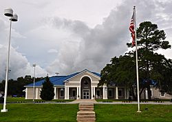
Freeport City Hall, September 2014.
|
|

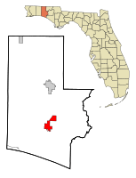
Location in Walton County and the state of Florida
|
|
| Country | United States of America |
| State | Florida |
| County | Walton |
| Settled | 1830 |
| Incorporated | 1963 |
| Government | |
| • Type | Mayor-Council |
| Area | |
| • Total | 19.00 sq mi (49.21 km2) |
| • Land | 18.94 sq mi (49.06 km2) |
| • Water | 0.06 sq mi (0.15 km2) |
| Elevation | 33 ft (10 m) |
| Population
(2020)
|
|
| • Total | 5,861 |
| • Density | 309.39/sq mi (119.46/km2) |
| Time zone | UTC-6 (Central (CST)) |
| • Summer (DST) | UTC-5 (CDT) |
| ZIP code |
32439
|
| Area code(s) | 850, 448 |
| FIPS code | 12-24825 |
| GNIS feature ID | 0282806 |
Freeport is a city in Walton County, Florida, United States. It is part of the Crestview–Fort Walton Beach–Destin, Florida Metropolitan Statistical Area. In 2020, about 5,861 people lived here, which was a big increase from 1,787 people in 2010. Freeport is one of Florida's fastest-growing cities. Its population grew a lot after a large group of neighborhoods called Hammock Bay was built.
Contents
History of Freeport
Freeport was started around 1830. It got its name because there were no fees to use the dock at the meeting point of Four Mile Creek and Lafayette Creek. This meant it was a "free port" for ships and boats.
In the past, Freeport's economy mostly depended on the local timber industry. This included sawmills and logging, as well as making turpentine from trees.
Later, when the railroad was built in DeFuniak Springs, Freeport lost its main role as the economic center of Walton County. Today, many people who live in Freeport work at Eglin Air Force Base, a large military base nearby.
Geography of Freeport
Freeport is located at 30°30′09″N 86°07′49″W / 30.502430°N 86.130255°W. The city is found along U.S. Route 331 and Florida State Road 20. U.S. 331 goes north and south to the east of the city. It leads north about 17 miles to DeFuniak Springs, which is the main town of Walton County. To the south, it goes about 11 miles to U.S. Route 98 near Santa Rosa Beach. Florida State Road 20 runs east and west through the main part of Freeport. It goes east about 17 miles to Ebro and west about 24 miles to Niceville.
According to the United States Census Bureau, the city covers a total area of about 19 square miles (49.21 square kilometers). Most of this area is land, and a very small part is water.
Freeport is located where Four Mile Creek and Lafayette Creek meet. These creeks flow into LaGrange Bayou, which then connects to the Choctawhatchee Bay.
Population and People
| Historical population | |||
|---|---|---|---|
| Census | Pop. | %± | |
| 1970 | 518 | — | |
| 1980 | 669 | 29.2% | |
| 1990 | 843 | 26.0% | |
| 2000 | 1,190 | 41.2% | |
| 2010 | 1,787 | 50.2% | |
| 2020 | 5,861 | 228.0% | |
| 2022 (est.) | 6,542 | 266.1% | |
| U.S. Decennial Census | |||
Freeport has grown a lot over the years. In 2010, there were 1,787 people living in the city. By 2020, the population had jumped to 5,861 people. This shows how quickly the city is expanding.
Most people in Freeport are White. In 2020, about 80% of the population was White. Other groups include Black or African American people, Native Americans, and Asians. About 10% of the population identified as Hispanic or Latino in 2020.
Schools in Freeport
Freeport has schools for students of all ages:
- Freeport Elementary School
- Freeport Middle School
- Freeport High School
See also
 In Spanish: Freeport (Florida) para niños
 | Lonnie Johnson |
 | Granville Woods |
 | Lewis Howard Latimer |
 | James West |

