Ebro, Florida facts for kids
Quick facts for kids
Ebro, Florida
|
|
|---|---|

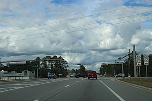
Looking northerly at the intersection of State Road 20 and State Road 79 in Ebro
|
|

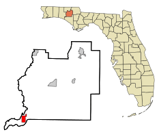
Location in Washington County and the state of Florida
|
|
| Country | |
| State | |
| County | Washington |
| Settled (Spanish Florida) |
1825 |
| Incorporated | 1967 |
| Named for | Ebro River |
| Government | |
| • Type | Mayor-Council |
| Area | |
| • Total | 4.83 sq mi (12.51 km2) |
| • Land | 4.72 sq mi (12.24 km2) |
| • Water | 0.10 sq mi (0.27 km2) |
| Elevation | 75 ft (23 m) |
| Population
(2020)
|
|
| • Total | 237 |
| • Density | 50.16/sq mi (19.37/km2) |
| Time zone | UTC-6 (Central (CST)) |
| • Summer (DST) | UTC-5 (CDT) |
| ZIP code |
32437
|
| Area code(s) | 850 |
| FIPS code | 12-19725 |
| GNIS feature ID | 0282067 |
Ebro is a small town in Washington County, Florida, United States. It is located in the Florida Panhandle, which is the northwestern part of Florida.
In 2020, about 237 people lived in Ebro. This was a slight decrease from 270 people in 2010. The town is part of the larger Panama City area.
People believe that the Spanish named the town after the Ebro River in Spain. This happened during the time when Spain controlled Florida.
Contents
Exploring Ebro's Location and Roads
Ebro is located in the southwestern part of Washington County. Its exact coordinates are 30°26′35″N 85°52′51″W / 30.44306°N 85.88083°W. It is also the closest town to the Northwest Florida Beaches International Airport.
Two main roads, State Road 20 and State Road 79, pass through Ebro. State Road 79 runs north and south. It connects Ebro to Bonifay (about 31 miles north) and Panama City Beach (about 16 miles south).
State Road 20 goes east and west through the middle of town. It leads to Blountstown (about 51 miles east) and Freeport (about 17 miles west).
The town of Ebro covers a total area of about 3.2 square miles (8.3 square kilometers). Most of this area is land, with a small part being water.
Ebro's Weather: A Humid Subtropical Climate
Ebro has a climate known as a humid subtropical climate. This means the summers are hot and humid. The winters are usually mild, not too cold.
People Living in Ebro: Census Information
| Historical population | |||
|---|---|---|---|
| Census | Pop. | %± | |
| 1970 | 125 | — | |
| 1980 | 233 | 86.4% | |
| 1990 | 255 | 9.4% | |
| 2000 | 250 | −2.0% | |
| 2010 | 270 | 8.0% | |
| 2020 | 237 | −12.2% | |
| U.S. Decennial Census | |||
Who Lives in Ebro? (2010 and 2020)
The United States Census Bureau collects information about people living in towns like Ebro. Here's a look at the different groups of people living there in 2010 and 2020:
| Race | People in 2010 | People in 2020 | % in 2010 | % in 2020 |
|---|---|---|---|---|
| White (NH) | 221 | 200 | 81.85% | 84.39% |
| Black or African American (NH) | 3 | 5 | 1.11% | 2.11% |
| Native American (NH) | 15 | 9 | 5.56% | 3.80% |
| Asian (NH) | 1 | 0 | 0.37% | 0.00% |
| Pacific Islander (NH) | 0 | 0 | 0.00% | 0.00% |
| Other race (NH) | 0 | 0 | 0.00% | 0.00% |
| Two or more races (NH) | 23 | 15 | 8.52% | 6.33% |
| Hispanic or Latino (any race) | 7 | 8 | 2.59% | 3.38% |
| Total | 270 | 237 |
In 2020, there were 237 people living in Ebro. These people made up 103 households, with 65 of them being families. In 2010, there were 270 people, 109 households, and 86 families.
Images for kids
See also
 In Spanish: Ebro (Florida) para niños
 | Victor J. Glover |
 | Yvonne Cagle |
 | Jeanette Epps |
 | Bernard A. Harris Jr. |


