Destin, Florida facts for kids
Quick facts for kids
Destin, Florida
|
||
|---|---|---|
| City of Destin | ||
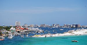
View of Destin from the Destin Harbor
|
||
|
||
| Nickname(s):
"World's Luckiest Fishing Village"
|
||
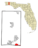
Location in Okaloosa County and the state of Florida
|
||
| Country | United States of America | |
| State | Florida | |
| County | Okaloosa | |
| Government | ||
| • Type | Council-Manager | |
| Area | ||
| • Total | 7.66 sq mi (19.83 km2) | |
| • Land | 7.49 sq mi (19.41 km2) | |
| • Water | 0.16 sq mi (0.42 km2) | |
| Elevation | 26 ft (8 m) | |
| Population
(2020)
|
||
| • Total | 13,931 | |
| • Density | 1,859.20/sq mi (717.82/km2) | |
| Time zone | UTC-6 (CST) | |
| • Summer (DST) | UTC-5 (CDT) | |
| ZIP codes |
32540-32541
|
|
| Area code(s) | 850 | |
| FIPS code | 12-17325 | |
| GNIS feature ID | 0281516 | |
| Website | www.cityofdestin.com | |
Destin is a city in Florida, United States. It is part of the larger Crestview–Fort Walton Beach–Destin area. In 2020, about 13,931 people lived there.
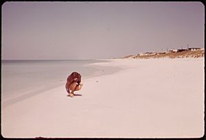
Destin is on Florida's beautiful Emerald Coast. It is famous for its bright white beaches and clear, emerald green waters. It started as a small fishing village. Now, it is a very popular place for tourists to visit. More than 80% of the 4.5 million visitors to the Emerald Coast each year come to Destin. The city calls itself "The World's Luckiest Fishing Village." It also says it has the biggest fishing boat fleet in Florida.
The city is on a piece of land that separates the Gulf of Mexico from Choctawhatchee Bay. This land was once a barrier island. Over time, storms and sea level changes connected it to the mainland. In the 1940s, it became an island again when a canal was built.
Contents
History of Destin
Destin is named after a fishing captain named Leonard Destin. He came from New London, Connecticut. Captain Destin settled in the area between 1845 and 1850. He built a home there. Captain Destin and his family fished in the area for many years.
The first tall apartment buildings, called condominiums, were built in Destin in the 1970s. Destin officially became a city in 1984. Since the 1980s, the city has grown very quickly.
Geography of Destin
Destin is located on a narrow strip of land. This land separates the Gulf of Mexico from Choctawhatchee Bay. This strip of land was once an island. But hurricanes and changes in sea level slowly connected it to the main land.
Destin is close to other cities. Fort Walton Beach is to the west. It is at the entrance of Santa Rosa Sound into Choctawhatchee Bay. North of Destin, across the bay, is Niceville. The Mid-Bay Bridge connects Destin and Niceville by road. U.S. Route 98 is the main road through Destin. It goes east to Panama City (about 56 miles) and west to Pensacola (about 48 miles).
At the western end of the land strip is East Pass. This pass separates Destin from Santa Rosa Island to the west. East Pass is the only way for water from Choctawhatchee Bay to flow into the Gulf of Mexico. Many people say the current pass was dug by hand. Then, water rushed in and made it wider in just a few hours. Old maps from Spanish, French, and English explorers show this pass. Workers often need to dig out the pass to keep boats able to use it.
"Crab Island" used to be two islands. They were made from sand that the Army Corps of Engineers dug up from East Pass. These islands were big enough for sea grass, small bushes, and nesting birds. Now, it is mostly a large sandbar. You can only see it when the tide is low. It is a popular spot for boats to anchor. The entrance to Destin Harbor is just north of the East Pass jetty. Destin Harbor is a calm water area between the beaches and the main part of Destin. It is protected by a sand spit called Holiday Isle. Many condominiums have been built along the harbor since the 1970s. Norriego Point helps protect the harbor. It was made twice as big to stop the land from washing away.
The city covers about 7.66 square miles (19.83 square kilometers). Most of this is land, and a small part is water.
Destin's Climate
| Climate data for Destin, Florida (Destin–Fort Walton Beach Airport), 1991–2020 normals, extremes 1996–present | |||||||||||||
|---|---|---|---|---|---|---|---|---|---|---|---|---|---|
| Month | Jan | Feb | Mar | Apr | May | Jun | Jul | Aug | Sep | Oct | Nov | Dec | Year |
| Record high °F (°C) | 89 (32) |
81 (27) |
86 (30) |
89 (32) |
98 (37) |
102 (39) |
99 (37) |
100 (38) |
100 (38) |
93 (34) |
91 (33) |
85 (29) |
102 (39) |
| Mean maximum °F (°C) | 74.1 (23.4) |
74.3 (23.5) |
79.6 (26.4) |
83.3 (28.5) |
91.1 (32.8) |
94.5 (34.7) |
95.2 (35.1) |
95.2 (35.1) |
93.5 (34.2) |
88.7 (31.5) |
81.1 (27.3) |
77.2 (25.1) |
97.3 (36.3) |
| Mean daily maximum °F (°C) | 63.1 (17.3) |
65.8 (18.8) |
70.7 (21.5) |
76.2 (24.6) |
83.5 (28.6) |
88.9 (31.6) |
90.9 (32.7) |
90.6 (32.6) |
88.5 (31.4) |
80.9 (27.2) |
72.1 (22.3) |
65.6 (18.7) |
78.1 (25.6) |
| Daily mean °F (°C) | 54.2 (12.3) |
56.9 (13.8) |
62.2 (16.8) |
68.1 (20.1) |
75.8 (24.3) |
81.5 (27.5) |
83.6 (28.7) |
83.2 (28.4) |
80.5 (26.9) |
72.1 (22.3) |
62.6 (17.0) |
56.6 (13.7) |
69.8 (21.0) |
| Mean daily minimum °F (°C) | 45.3 (7.4) |
47.9 (8.8) |
53.6 (12.0) |
60.1 (15.6) |
68.0 (20.0) |
74.1 (23.4) |
76.2 (24.6) |
75.8 (24.3) |
72.4 (22.4) |
63.2 (17.3) |
53.0 (11.7) |
47.5 (8.6) |
61.4 (16.3) |
| Mean minimum °F (°C) | 28.6 (−1.9) |
33.2 (0.7) |
38.8 (3.8) |
49.5 (9.7) |
57.9 (14.4) |
69.3 (20.7) |
72.2 (22.3) |
72.5 (22.5) |
64.5 (18.1) |
49.0 (9.4) |
38.7 (3.7) |
35.0 (1.7) |
27.1 (−2.7) |
| Record low °F (°C) | 20 (−7) |
23 (−5) |
30 (−1) |
41 (5) |
49 (9) |
62 (17) |
66 (19) |
66 (19) |
55 (13) |
42 (6) |
30 (−1) |
22 (−6) |
20 (−7) |
| Average precipitation inches (mm) | 4.52 (115) |
4.96 (126) |
4.70 (119) |
4.55 (116) |
3.22 (82) |
4.70 (119) |
5.77 (147) |
6.08 (154) |
5.18 (132) |
2.82 (72) |
4.13 (105) |
4.72 (120) |
55.35 (1,406) |
| Average precipitation days (≥ 0.01 in) | 10.0 | 9.4 | 8.7 | 7.9 | 6.4 | 9.7 | 11.2 | 12.4 | 8.2 | 6.1 | 8.9 | 10.6 | 109.5 |
| Source: NOAA (mean maxima and minima 2006–2020) | |||||||||||||
Environmental Challenges
A study in 2013 said that Destin is one of the Florida cities most at risk of being covered by water. A report in 2019 said that parts of the beach were "critically eroded." This means they were washing away.
The city received $11 million from the Deepwater Horizon oil spill settlement. This money was used to help stop the land from washing away at Norriego Point. This point protects the important harbor. The city is still working on plans to deal with rising sea levels and beach erosion.
People of Destin
| Historical population | |||
|---|---|---|---|
| Census | Pop. | %± | |
| 1990 | 8,080 | — | |
| 2000 | 11,119 | 37.6% | |
| 2010 | 12,305 | 10.7% | |
| 2020 | 13,931 | 13.2% | |
| U.S. Decennial Census | |||
Population Changes
| Race | Pop 2010 | Pop 2020 | % 2010 | % 2020 |
|---|---|---|---|---|
| White (NH) | 10,645 | 10,930 | 86.51% | 78.46% |
| Black or African American (NH) | 180 | 337 | 1.46% | 2.42% |
| Native American or Alaska Native (NH) | 31 | 46 | 0.25% | 0.33% |
| Asian (NH) | 248 | 320 | 2.02% | 2.30% |
| Pacific Islander or Native Hawaiian (NH) | 13 | 10 | 0.11% | 0.07% |
| Some other race (NH) | 81 | 117 | 0.66% | 0.84% |
| Two or more races/Multiracial (NH) | 311 | 921 | 2.53% | 6.61% |
| Hispanic or Latino (any race) | 796 | 1,250 | 6.47% | 8.97% |
| Total | 12,305 | 13,931 |
In 2020, there were 13,931 people living in Destin. There were 6,377 households and 3,576 families. In 2010, there were 12,305 people.
Fun Things to Do in Destin
Tourism and Beaches
Destin's white beaches and emerald waters attract many visitors. Florida's Department of Environmental Protection says that over 80% of the 4.5 million yearly visitors to the Emerald Coast come to Destin. Visitors can rent fishing boats from the harbor. There are 12 places in the city where you can get to the beach. One of these is Henderson Beach State Recreation Area. Part of the Gulf Islands National Seashore is also nearby on Santa Rosa Island.
The sand on Destin's beaches is some of the whitest in the world. This sand comes from the Appalachian Mountains. It is made of tiny pieces of quartz crystal. This makes the sand look like sugar. The sand flows down the Apalachicola River and into the Gulf of Mexico. Ocean currents then carry the sand west along the Gulf Coast. It settles from east of Panama City all the way to the Alabama coast.
Many events happen in Destin all year. In October, the annual Destin Fishing Rodeo brings many people who love to fish. This event has been happening since 1948. Also in October is the Destin Seafood Festival. Here, you can find fresh seafood and see art from local artists.
Destin has many hotels and motels. There are also many tall condominium buildings. The first condominiums were built in the 1970s, and new ones are still being built. Visitors are very important to Destin's economy. The city's population of about 12,000 people grows to 40,000 during the busy tourist season.
Many homes in Destin are vacation rentals. These include condos, beach houses, and cottages. Most vacation homes are on the south side of US Highway 98, near the Gulf. Most local residents live on the north side of US Highway 98, by the Choctawhatchee Bay.
Other popular places to visit are near Destin. Sandestin is to the east. It is a popular place for golf and beaches. Further east are Seaside, where the movie The Truman Show was filmed, and Grayton Beach. To the west are Navarre Beach and Pensacola Beach. The Civil War fort, Fort Pickens, is at the western end of Santa Rosa Island.
Libraries in Destin
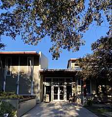
The Destin Library opened in 1940. It is part of the Okaloosa County Public Library system.
Education in Destin
The Okaloosa County School District runs the public schools in Destin. These include:
- Destin Elementary School
- Destin Middle School
- Destin High School (which is a public charter school)
Famous People from Destin
- Emeril Lagasse, a famous chef
- Joe A. Rector, an artist
- Jerry Jones, a businessman and owner of the Dallas Cowboys football team
See also
 In Spanish: Destin para niños
 | Valerie Thomas |
 | Frederick McKinley Jones |
 | George Edward Alcorn Jr. |
 | Thomas Mensah |


