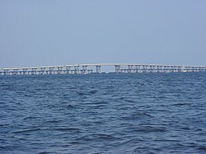
Santa Rosa Sound facts for kids
Santa Rosa Sound is a long, narrow body of water in Florida. It connects two larger bays, Pensacola Bay and Choctawhatchee Bay. Think of it like a watery highway between these two big areas.
The northern side of the sound touches the Fairpoint Peninsula and parts of Santa Rosa County and Okaloosa County. To the south, Santa Rosa Island (also known as Okaloosa Island further east) separates the sound from the huge Gulf of Mexico.
A major water route called the Gulf Intracoastal Waterway travels through Santa Rosa Sound. This waterway helps boats move safely between Pensacola Beach and Fort Walton Beach.
Towns and Cities Along the Sound
Many communities are located right along the shores of Santa Rosa Sound. These towns offer beautiful views and access to the water.
- Gulf Breeze, Florida
- Pensacola Beach, Florida
- Navarre, Florida
- Navarre Beach, Florida
- Mary Esther, Florida
- Fort Walton Beach, Florida
Bridges Over Santa Rosa Sound
Three main bridges cross Santa Rosa Sound. They allow cars and people to travel between the mainland and the barrier islands on the south side. These bridges are important connections for the communities here.
Two of these bridges have the lowest clearance for boats on the Gulf Intracoastal Waterway. This means that many sailboats with very tall masts cannot fit under them. Because of this, these taller sailboats often have to go out into the open Gulf of Mexico to bypass the sound.
Here are the bridges crossing Santa Rosa Sound, along with the towns they connect and how much space they offer for boats underneath:
- Brooks Bridge: Connects Fort Walton Beach to Okaloosa Island. It has 50 feet of clearance above the water.
- Navarre Beach Causeway: Connects Navarre to Navarre Beach. It has 55 feet of clearance.
- Bob Sikes Bridge (often called the "Pensacola Beach Bridge"): Connects Gulf Breeze to Pensacola Beach. This bridge has the most clearance at 65 feet.
 | William Lucy |
 | Charles Hayes |
 | Cleveland Robinson |


