Santa Rosa County, Florida facts for kids
Quick facts for kids
Santa Rosa County
|
||
|---|---|---|

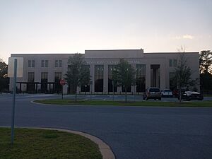
Santa Rosa County Courthouse
|
||
|
||

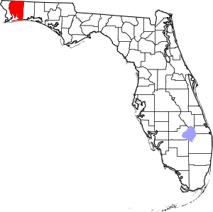
Location within the U.S. state of Florida
|
||
 Florida's location within the U.S. |
||
| Country | ||
| State | ||
| Founded | February 18, 1842 | |
| Named for | Saint Rose of Viterbo | |
| Seat | Milton | |
| Largest community | Navarre | |
| Area | ||
| • Total | 1,174 sq mi (3,040 km2) | |
| • Land | 1,012 sq mi (2,620 km2) | |
| • Water | 162 sq mi (420 km2) 13.8%% | |
| Population
(2020)
|
||
| • Total | 188,000 | |
| • Estimate
(2023)
|
203,162 |
|
| • Density | 160.1/sq mi (61.83/km2) | |
| Time zone | UTC−6 (Central) | |
| • Summer (DST) | UTC−5 (CDT) | |
| Congressional district | 1st | |
Santa Rosa County is a county located in the northwest part of Florida. A county is like a smaller area within a state, often with its own local government. In 2020, about 188,000 people lived here. The main town, or county seat, is Milton. It's right in the middle of the county.
Other important communities in Santa Rosa County include Navarre, Pace, and Gulf Breeze. Navarre is the biggest community, with around 45,000 people. Santa Rosa County is part of a larger city area called the Pensacola Metropolitan Statistical Area. This area also includes Escambia County.
Contents
History of Santa Rosa County
The first European to visit Santa Rosa County might have been Diego Maldonado. He was part of an expedition led by Tristan de Luna. Native American groups lived here for a long time, until the late 1700s. A Spanish mission (a type of church settlement) for the Apalachee people might have been in Floridatown from 1718 to 1740.
Santa Rosa County was officially created in 1842. It was formed from a part of Escambia County. The county got its name from a nearby island, which was named after a Catholic saint, Rosa de Viterbo.
In 2005, Santa Rosa County changed a rule that had stopped people from buying alcohol.
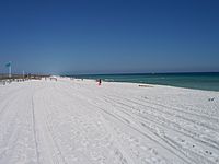
The county has grown a lot, especially in Navarre, Pace, and Gulf Breeze. Many tourists now visit Santa Rosa County. They come for the beautiful beaches and protected natural areas. These areas are great for kayaking, hiking, and camping.
Geography and Natural Areas
Santa Rosa County covers about 1,174 square miles. Most of this area, about 1,012 square miles, is land. The rest, about 162 square miles, is water.
National Protected Lands
- Choctawhatchee National Forest (part of it is in Santa Rosa County)
Different Regions of the County
Santa Rosa County can be split into three main parts: South Santa Rosa, Central Santa Rosa, and North Santa Rosa. These areas are named after the main roads that cross the county from east to west.

South Santa Rosa County
This area stretches from Holley and Navarre in the east to Gulf Breeze in the west. It follows U.S. Highway 98. A part of Santa Rosa Island, which includes Navarre Beach, is also in South Santa Rosa County. Large bodies of water like Santa Rosa Sound, Pensacola Bay, and East Bay are very important here. They affect how people live and what kinds of homes are built. This area is growing fast. Many people live here and travel to Pensacola for work. Others work at military bases like Hurlburt Field and Eglin Air Force Base.
Central Santa Rosa County
This part of the county is north of the bays and south of the large forests. It grew up along an old road called the Old Spanish Trail. Today, U.S. Highway 90 follows this old trail. It is the main road connecting this region. Even with recent growth, Central Santa Rosa County still feels very rural. It has a traditional Southern culture. The communities of Pace and Milton are in this region. Both have populations of about 30,000 people. Milton, the county seat, is where the old trail crossed the Blackwater River. To the west of Milton, Pace has grown a lot with new homes and businesses. Interstate 10 also goes through this area. The U.S. Navy has a presence here with Whiting Field and NOLF Spencer Field.
North Santa Rosa County
This area is mostly forests and farms. The only town in the north is Jay. Most development has happened along State Road 4. This road goes through the northern parts of Escambia, Santa Rosa, and Okaloosa counties. In the 1970s and 1980s, a large oil and natural gas field near Jay made many farmers very rich. However, most of the oil is gone now. People in this area have mostly gone back to farming and working in forestry.
State Road 87 runs through the county from north to south. It connects U.S. Highway 98 to the border with Escambia County, Alabama near Brewton. This road is very important for people to leave the county safely during hurricanes.
Neighboring Counties
- Escambia County, Alabama - to the north
- Okaloosa County, Florida - to the east
- Escambia County, Florida - to the west
Population and People
| Historical population | |||
|---|---|---|---|
| Census | Pop. | %± | |
| 1850 | 2,883 | — | |
| 1860 | 5,480 | 90.1% | |
| 1870 | 3,312 | −39.6% | |
| 1880 | 6,645 | 100.6% | |
| 1890 | 7,961 | 19.8% | |
| 1900 | 10,293 | 29.3% | |
| 1910 | 14,897 | 44.7% | |
| 1920 | 13,670 | −8.2% | |
| 1930 | 14,083 | 3.0% | |
| 1940 | 16,085 | 14.2% | |
| 1950 | 18,554 | 15.3% | |
| 1960 | 29,547 | 59.2% | |
| 1970 | 37,741 | 27.7% | |
| 1980 | 55,988 | 48.3% | |
| 1990 | 81,608 | 45.8% | |
| 2000 | 117,743 | 44.3% | |
| 2010 | 151,372 | 28.6% | |
| 2020 | 188,000 | 24.2% | |
| 2023 (est.) | 203,162 | 34.2% | |
| U.S. Decennial Census 1790-1960 1900-1990 1990-2000 2010-2019 |
|||
In 2020, there were 188,000 people living in Santa Rosa County. There were 65,697 households and 47,876 families.
In 2000, the county had 117,743 people. About 36.5% of households had children under 18. Around 62.2% of households were married couples living together. The average household had 2.63 people.
The population was spread out by age. About 26.6% were under 18. Around 31.1% were between 25 and 44 years old. The median age was 37 years. This means half the people were younger than 37, and half were older.
Libraries in Santa Rosa County
The Santa Rosa County Library System has five libraries. You can find them in these communities:
- Navarre
- Gulf Breeze
- Jay
- Milton
- Pace
Communities in Santa Rosa County
The biggest communities in the county are Navarre and Pace.
Cities
Town
Census-Designated Places
These are areas that are like towns but are not officially incorporated as cities or towns.
- Allentown
- Avalon
- Bagdad
- Berrydale
- Brownsdale
- Chumuckla
- Cobbtown
- Dickerson City
- Dixonville
- East Milton
- Fidelis
- Floridatown
- Garcon Point
- Harold
- Holley
- Midway
- Mount Carmel
- Mulat
- Munson
- Navarre
- Navarre Beach
- Oriole Beach
- Pace
- Pea Ridge
- Pine Level
- Springhill
- Tiger Point
- Wallace
- Whitfield
- Woodlawn Beach
Old Ghost Towns
- Coon Hill
- Floridale
Transportation in Santa Rosa County
Airports
- Fort Walton Beach Airport
- Peter Prince Field
Major Highways
 I-10
I-10 US 90
US 90 US 98
US 98 SR 4
SR 4 SR 87
SR 87 SR 89
SR 89 SR 281
 SR 399
Images for kids
See also
 In Spanish: Condado de Santa Rosa para niños
 | Shirley Ann Jackson |
 | Garett Morgan |
 | J. Ernest Wilkins Jr. |
 | Elijah McCoy |


