
Okaloosa County, Florida facts for kids
Quick facts for kids
Okaloosa County
|
|||
|---|---|---|---|

The Okaloosa County courthouse in March 2008
|
|||
|
|||

Location within the U.S. state of Florida
|
|||
 Florida's location within the U.S. |
|||
| Country | |||
| State | |||
| Founded | September 7, 1915 | ||
| Seat | Crestview | ||
| Largest city | Crestview | ||
| Area | |||
| • Total | 1,082 sq mi (2,800 km2) | ||
| • Land | 930 sq mi (2,400 km2) | ||
| • Water | 152 sq mi (390 km2) 14.0%% | ||
| Population
(2020)
|
|||
| • Total | 211,668 | ||
| • Estimate
(2023)
|
218,464 |
||
| • Density | 195.63/sq mi (75.53/km2) | ||
| Time zone | UTC−6 (Central) | ||
| • Summer (DST) | UTC−5 (CDT) | ||
| Congressional district | 1st | ||


Okaloosa County is a county located in the northwestern part of Florida. It stretches from the beautiful Gulf of Mexico all the way up to the border with Alabama. As of 2020, about 211,668 people lived here.
The main town, or "county seat," where the local government is located, is Crestview. Okaloosa County is also part of a larger area called the Crestview-Fort Walton Beach-Destin Metropolitan Statistical Area.
Contents
A Look Back in Time: Okaloosa County's History
Okaloosa County was officially created on September 7, 1915. It was formed from parts of two nearby counties: Santa Rosa County and Walton County.
The name Okaloosa means "black water." This comes from the Choctaw language, where oka means "water" and lusa means "black." The name might have come from a similar language spoken by the Chatot people who lived in the Florida Panhandle long ago.
Exploring Okaloosa County's Geography
Okaloosa County covers a total area of about 1,082 square miles. Most of this (930 square miles) is land, and about 152 square miles (14%) is water.
You'll find Fort Walton Beach here, along with three important United States Air Force bases. These include Duke Field in the northern part of the county, and Eglin AFB and Hurlburt Field in the south.
Neighboring Counties Around Okaloosa
Okaloosa County shares its borders with several other counties:
- Covington County, Alabama to the north
- Walton County to the east
- Santa Rosa County to the west
- Escambia County, Alabama to the northwest
Protected Natural Areas in Okaloosa County
Okaloosa County is home to parts of some important protected natural areas:
- Choctawhatchee National Forest
- Gulf Islands National Seashore
State Parks and Forests for Outdoor Fun
There are also great state parks and forests to explore:
- Blackwater River State Forest: This huge forest covers about 189,594 acres. It stretches across Okaloosa and Santa Rosa counties.
- Fred Gannon Rocky Bayou State Recreation Area: This park has 357 acres of sand pine forest right along the Choctawhatchee Bay. It's a great place for camping, hiking, fishing, and canoeing. You can find it about 5 miles east of Niceville on State Road 20.
- Henderson Beach State Park: Enjoy 1.3 miles of beautiful sugar-sand beach along the Gulf of Mexico. This park offers places for camping, RVs, and picnics. It also has a pavilion and a boardwalk. It's located just east of downtown Destin on U.S. 98.

Understanding Okaloosa County's Population
| Historical population | |||
|---|---|---|---|
| Census | Pop. | %± | |
| 1920 | 9,360 | — | |
| 1930 | 9,897 | 5.7% | |
| 1940 | 12,900 | 30.3% | |
| 1950 | 27,533 | 113.4% | |
| 1960 | 61,175 | 122.2% | |
| 1970 | 88,187 | 44.2% | |
| 1980 | 109,920 | 24.6% | |
| 1990 | 143,776 | 30.8% | |
| 2000 | 170,498 | 18.6% | |
| 2010 | 180,822 | 6.1% | |
| 2020 | 211,668 | 17.1% | |
| 2023 (est.) | 218,464 | 20.8% | |
| 2020 | |||
The population of Okaloosa County has grown a lot over the years. In 2020, there were 211,668 people living here. This included 79,235 households and 51,719 families.
In 2010, about 33.10% of households had children under 18 living with them. The average household had about 2.49 people. The average family size was 2.94 people.
The median age in 2010 was 36 years old. This means half the people were younger than 36 and half were older. For every 100 females, there were about 102.20 males.
In 2015, the median income for a household in the county was $55,880. This gives us an idea of how much money families earned on average.
Learning and Libraries in Okaloosa County
Education Opportunities
The public schools in Okaloosa County are managed by the Okaloosa County School District.
Northwest Florida State College helps over 10,000 people in Okaloosa County each year. They offer different degrees and certificates. The college has four campuses in Okaloosa County: Niceville, Crestview, Fort Walton Beach, and Hurlburt Field.
Public Libraries for Everyone
Okaloosa County has a great system of libraries called the Okaloosa County Public Library Cooperative. It started in 1997 with the county and the cities of Crestview, Mary Esther, and Niceville. By 2000, Fort Walton Beach, Valparaiso, and Destin also joined. This cooperative helps make sure everyone has access to books and learning.
Getting Around: Transportation in Okaloosa County
Airports for Travel
- Bob Sikes Airport
- Destin–Fort Walton Beach Airport
Major Highways Connecting the County
You can find several important highways in Okaloosa County:
 I-10 (Interstate 10)
 US 90 (U.S. Highway 90)
 US 98 (U.S. Highway 98)
 SR 4
SR 4 SR 85
SR 85 SR 145
 SR 188
 SR 189
 SR 293
 SR 393
 SR 397
Bus Services for Local Travel
Emerald Coast Rider (which used to be called Okaloosa County Transit) offers bus services throughout the county.
Cities and Towns in Okaloosa County
Cities to Explore
Smaller Towns in the County
Census-Designated Places (CDPs)
These are areas that are like towns but don't have their own local government:
- Eglin AFB
- Hurlburt Field
- Lake Lorraine
- Ocean City
- Wright
Other Unincorporated Communities
- Baker
- Blackman
- Bluewater Bay
- Campton
- Deerland
- Dorcas
- Escambia Farms
- Florosa
- Garden City
- Holt
- Milligan
- Okaloosa Island
- Seminole
- Svea
- Timpoochee
- WynneHaven Beach
Images for kids
-
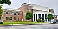
Okaloosa County's new Courthouse, where the first case was held on January 2, 2019.
-
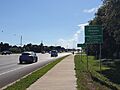
Several road signs at the county and Destin boundary.


See also
 In Spanish: Condado de Okaloosa para niños
