
Gulf Islands National Seashore facts for kids
Quick facts for kids Gulf Islands National Seashore |
|
|---|---|
|
IUCN Category V (Protected Landscape/Seascape)
|
|

Gulf Islands National Seashore, near Pensacola
|
|

Gulf Islands National Seashore
Location in Florida

Gulf Islands National Seashore
Location in the United States
|
|
| Location | Escambia / Santa Rosa /Florida / Okaloosa, and Jackson / Harrison counties, Mississippi, USA |
| Nearest city | Pensacola, FL (Fort Barrancas) Navarre, FL (Santa Rosa Island area) Gulf Breeze, FL (Naval Live Oaks area) Destin, FL (Okaloosa Island area) Pascagoula, MS (Mississippi area) |
| Area | 135,457.89 acres (548.1786 km2) 99,083.64 acres (40,097.73 ha) federal |
| Established | January 8, 1971 |
| Visitors | 5,600,240 (in 2019) |
| Governing body | U.S. National Park Service |
| Website | Gulf Islands National Seashore |
The Gulf Islands National Seashore is a special place where you can enjoy nature and learn about history. It protects beautiful islands and coastal areas along the Gulf of Mexico in Florida and Mississippi. This area offers many fun activities and helps keep important natural and historical sites safe.

Contents
Exploring the Florida Area
The Florida part of the seashore has amazing white sand beaches. These beaches stretch for miles and are mostly untouched. You can also find old forts and nature trails here. Near Pensacola, Florida, you can visit the Naval Live Oaks Reservation. This area has more beaches and military forts. All the places in Florida are easy to reach by car.
Discovering the Mississippi Area
The Mississippi part of the seashore is different. It has natural beaches, historic spots, and places where wildlife lives. Some islands here can only be reached by boat. You can also explore bayous, nature trails, and picnic areas. The Davis Bayou Area is the only part in Mississippi you can drive to. Islands like Petit Bois, Horn, East Ship, West Ship, and Cat islands are only for boat trips. A special area called the Gulf Islands Wilderness protects parts of Petit Bois Island and Horn Island.
Storms and Repairs
Sometimes, big storms like hurricanes hit the Gulf Coast. In 2004 and 2005, storms caused a lot of damage to the seashore's buildings and roads. But don't worry, everything was fixed! Roads, parking lots, campgrounds, and visitor centers are all working again.
In September 2020, Hurricane Sally also caused damage. Areas like Perdido Key had flooding, and some sand dunes were flattened. Johnson Beach National Seashore was hit hard, and parts of it turned into smaller islands. Workers are always busy bringing in new sand and plants to fix storm damage. This helps keep the seashore beautiful and safe.
Islands to Visit
Here are the main islands that are part of the Gulf Islands National Seashore, listed from east to west:
- Santa Rosa Island
- Perdido Key
- Petit Bois Island
- Sand Island
- Horn Island
- East Ship Island
- West Ship Island
- Cat Island
History of the Seashore
The Gulf Islands National Seashore was officially created on January 8, 1971. The National Park Service manages and protects this special area. A part of it was also named a "wilderness area" on November 10, 1978. This means those areas are kept as wild and natural as possible.
Visitor Centers
There are four visitor centers in the Gulf Islands National Seashore. These centers have staff from the National Park Service who can help you. Three centers are in Florida, and one is in Mississippi.
Florida Visitor Centers
- Fort Barrancas Visitor Center (located at Naval Air Station Pensacola, Florida)
- Fort Pickens Visitor Center, Pensacola Beach, Florida
Mississippi Visitor Centers
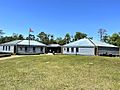
- Davis Bayou Area Visitor Center (located in Ocean Springs, Mississippi)
Camping Adventures
You can go camping in two main campgrounds at the National Seashore. There are also places for "primitive camping," which means camping in more natural, undeveloped spots. You can find out about camping fees on the seashore's website.
Camping in Florida
The Fort Pickens Campground in Florida is a developed campground. It has paved roads and campsites with water and electricity for RVs and tents. The campground is surrounded by small oak trees, ponds, and a pine forest. It's located on a barrier island between Pensacola Bay and the Gulf of Mexico. There are restrooms and showers available. A small store also reopened here after being fixed from storm damage. You can reserve spots online for some months, or get them first-come, first-served at other times.
Camping in Mississippi
The Davis Bayou Campground in Mississippi is also developed. It offers water and electricity for RVs and tents. The campground has paved roads and is set in an oak and pine forest next to a bayou. Restrooms and showers are available. You can reserve campsites online. Any spots not reserved are available first-come, first-served.
Primitive Camping
If you like a more rugged adventure, you can try primitive camping on some barrier islands. You'll need a boat or have to hike to these spots. This type of camping is allowed on Perdido Key in Florida (east of Johnson Beach). In Mississippi, you can primitive camp on government-owned parts of Petit Bois, Horn, East Ship, and Cat islands. Camping in these "wilderness areas" offers a unique experience along the Gulf Coast.
Gulf Oil Spill Impact
In 2010, a big oil spill called the Deepwater Horizon oil spill happened in the Gulf of Mexico. Oil and tar started washing up on the beaches of Gulf Islands National Seashore. This caused fishing and swimming to be banned in some areas. The oil spill affected all the large islands in the seashore.
Entrance Fees
Some areas of the Gulf Islands National Seashore have entrance fees. For example, you'll pay a fee to enter the Fort Pickens area at Pensacola Beach and the Johnson Beach Area at Perdido Key in Florida. A typical car entrance fee is US$25, and it's good for seven days. You can also buy an annual pass for US$45.
The "America the Beautiful - National Parks and Federal Recreational Lands Pass" is also accepted here. Many other parts of the National Seashore do not charge an entrance fee.
Images for kids
-
Davis Bayou Area Visitor Center

