Jackson County, Mississippi facts for kids
Quick facts for kids
Jackson County
|
||
|---|---|---|

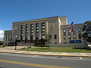
The Jackson County Courthouse in Pascagoula
|
||
|
||

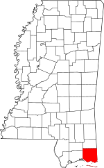
Location within the U.S. state of Mississippi
|
||
 Mississippi's location within the U.S. |
||
| Country | ||
| State | ||
| Founded | 1812 | |
| Named for | Andrew Jackson | |
| Seat | Pascagoula | |
| Largest city | Pascagoula | |
| Area | ||
| • Total | 1,043 sq mi (2,700 km2) | |
| • Land | 723 sq mi (1,870 km2) | |
| • Water | 321 sq mi (830 km2) 31% | |
| Population
(2020)
|
||
| • Total | 143,252 | |
| • Estimate
(2023)
|
146,389 |
|
| • Density | 137.35/sq mi (53.030/km2) | |
| Time zone | UTC−6 (Central) | |
| • Summer (DST) | UTC−5 (CDT) | |
| Congressional district | 4th | |
Jackson County is a place in the state of Mississippi, USA. It is located at the southeastern tip of Mississippi. A "county" is like a large district within a state.
As of 2020, about 143,252 people lived here. This makes it the fifth-most populated county in Mississippi. The main town, or county seat, is Pascagoula.
The county was named after Andrew Jackson. He was a famous general in the United States Army. Later, he became a President of the United States.
Jackson County is part of the Pascagoula Metropolitan Statistical Area. This means it's part of a larger area with many towns and cities. The county has sandy soil and is in a forest area called Piney Woods. It shares a border with the state of Alabama on its east side.
Sadly, Jackson County has been hit by strong hurricanes. Hurricane Camille in 1969 and Hurricane Katrina in 2005 caused a lot of damage.
Contents
Geography
Jackson County covers a total area of about 1,043 square miles. Out of this, 723 square miles are land, and 321 square miles are water. This makes it the largest county in Mississippi by total area.
It's important to know that even though it's called Jackson County, the big city of Jackson is not here. The City of Jackson is actually in a different county called Hinds County.
Major roads
 Interstate 10
 U.S. Highway 90
 Mississippi Highway 57
 Mississippi Highway 63
 Mississippi Highway 609
 Mississippi Highway 611
 Mississippi Highway 613
 Mississippi Highway 614
Neighboring counties
- George County - to the north
- Mobile County, Alabama - to the east
- Harrison County - to the west
- Stone County - to the northwest
Protected natural areas
- De Soto National Forest (part of it)
- Grand Bay National Wildlife Refuge (part of it)
- Gulf Islands National Seashore (part of it)
- Mississippi Sandhill Crane National Wildlife Refuge
Population facts
| Historical population | |||
|---|---|---|---|
| Census | Pop. | %± | |
| 1820 | 1,682 | — | |
| 1830 | 1,792 | 6.5% | |
| 1840 | 1,965 | 9.7% | |
| 1850 | 3,196 | 62.6% | |
| 1860 | 4,122 | 29.0% | |
| 1870 | 4,362 | 5.8% | |
| 1880 | 7,607 | 74.4% | |
| 1890 | 11,251 | 47.9% | |
| 1900 | 16,513 | 46.8% | |
| 1910 | 15,451 | −6.4% | |
| 1920 | 19,208 | 24.3% | |
| 1930 | 15,973 | −16.8% | |
| 1940 | 20,601 | 29.0% | |
| 1950 | 31,401 | 52.4% | |
| 1960 | 55,522 | 76.8% | |
| 1970 | 87,975 | 58.5% | |
| 1980 | 118,015 | 34.1% | |
| 1990 | 115,243 | −2.3% | |
| 2000 | 131,420 | 14.0% | |
| 2010 | 139,668 | 6.3% | |
| 2020 | 143,252 | 2.6% | |
| 2023 (est.) | 146,389 | 4.8% | |
| U.S. Decennial Census 1790-1960 1900-1990 1990-2000 2010-2013 |
|||
As of the 2020 United States census, there were 143,252 people living in Jackson County. There were 56,323 households and 38,007 families.
Schools and education
There are several school districts in Jackson County:
- The Jackson County School District serves areas like Hurley, Wade, and Vancleave.
- The Pascagoula-Gautier School District serves the cities of Pascagoula and Gautier.
- The Moss Point School District serves Moss Point and most of Escatawpa.
- The Ocean Springs School District serves the city of Ocean Springs.
Towns and places
Jackson County has several cities and other communities.
Cities
- Gautier
- Moss Point
- Ocean Springs
- Pascagoula (This is the county seat)
Census-designated places
These are areas that are like towns but are not officially incorporated as cities.
- Big Point
- Escatawpa
- Gulf Hills
- Gulf Park Estates
- Helena
- Hurley
- Latimer
- St. Martin
- Vancleave
- Wade
Unincorporated places
These are small communities that are not part of any city or census-designated place.
- East Moss Point
- Poticaw Landing
Ghost towns
Former census-designated places
- Hickory Hills, which later became part of the city of Gautier.
See also
 In Spanish: Condado de Jackson (Misisipi) para niños
 | Sharif Bey |
 | Hale Woodruff |
 | Richmond Barthé |
 | Purvis Young |


