Hurley, Mississippi facts for kids
Quick facts for kids
Hurley, Mississippi
|
|
|---|---|

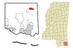
Location of Hurley, Mississippi
|
|
| Country | |
| State | |
| County | Jackson |
| Area | |
| • Total | 5.15 sq mi (13.34 km2) |
| • Land | 5.13 sq mi (13.30 km2) |
| • Water | 0.02 sq mi (0.04 km2) |
| Elevation | 102 ft (31 m) |
| Population
(2020)
|
|
| • Total | 1,557 |
| • Density | 303.21/sq mi (117.07/km2) |
| Time zone | UTC-6 (Central (CST)) |
| • Summer (DST) | UTC-5 (CDT) |
| ZIP code |
39555
|
| Area code(s) | 228 |
| FIPS code | 28-34340 |
| GNIS feature ID | 0671597 |
Hurley is a small place in Jackson County, Mississippi, United States. It is called an "unincorporated community" because it does not have its own local government like a city. It is also a "census-designated place" (CDP), which means the United States Census Bureau has defined it for gathering population data.
Hurley is part of the larger Pascagoula area. This area is known as a "Metropolitan Statistical Area," which is a region with a large population and close economic ties. In 2010, about 1,551 people lived in Hurley. By 2020, the population had grown slightly to 1,557.
Contents
Where is Hurley Located?
Hurley is found in the northeastern part of Jackson County. You can find its exact spot using coordinates: 30°39′48″N 88°29′58″W / 30.66333°N 88.49944°W.
Roads and Borders
Mississippi Highway 613 runs right through the middle of Hurley. This highway goes north for about 23 miles (37 km) to a town called Lucedale. If you go south on Highway 613 for about 24 miles (39 km), you will reach Pascagoula. Pascagoula is the main city and the "county seat" for Jackson County.
Another road, Mississippi Highway 614, marks the southern edge of Hurley. This highway goes west about 4 miles (6 km) to Wade. If you head east on Highway 614 for about 5 miles (8 km), you will reach the border of Alabama.
Land and Water Area
The total area of Hurley is about 5.15 square miles (13.3 square kilometers). Most of this area is land, about 5.13 square miles (13.30 square kilometers). Only a very small part, about 0.02 square miles (0.04 square kilometers), is water.
Who Lives in Hurley?
| Historical population | |||
|---|---|---|---|
| Census | Pop. | %± | |
| 2020 | 1,557 | — | |
| U.S. Decennial Census | |||
The 2020 United States census counted 1,557 people living in Hurley. There were 507 households and 362 families.
People in Hurley (2020)
| Group | Number | Percentage |
|---|---|---|
| White (not Hispanic) | 1,445 | 92.81% |
| Black or African American (not Hispanic) | 22 | 1.41% |
| Asian | 3 | 0.19% |
| Other/Mixed | 58 | 3.73% |
| Hispanic or Latino | 29 | 1.86% |
Keeping Hurley Safe
Hurley has services to help keep the community safe.
Fire Department
The North East Jackson County Fire Department is in charge of putting out fires and helping in emergencies.
Law Enforcement
The Jackson County Sheriff's Office provides police services for the people living in Hurley.
Schools in Hurley
Students in Hurley attend schools that are part of the Jackson County School District. This district has schools for all age groups, from young children to teenagers.
Elementary Schools
- East Central Lower Elementary School
- East Central Upper Elementary School
Middle School
- East Central Middle School
High School
- East Central High School is where older students go. The football team here was the South State Football Champions in 2017/2018!
See also
 In Spanish: Hurley (Misisipi) para niños
 | Dorothy Vaughan |
 | Charles Henry Turner |
 | Hildrus Poindexter |
 | Henry Cecil McBay |


