
Stone County, Mississippi facts for kids
Quick facts for kids
Stone County
|
|
|---|---|

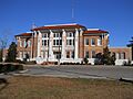
Stone County Courthouse in Wiggins
|
|

Location within the U.S. state of Mississippi
|
|
 Mississippi's location within the U.S. |
|
| Country | |
| State | |
| Founded | 1916 |
| Named for | John M. Stone |
| Seat | Wiggins |
| Largest city | Wiggins |
| Area | |
| • Total | 448 sq mi (1,160 km2) |
| • Land | 445 sq mi (1,150 km2) |
| • Water | 2.6 sq mi (7 km2) 0.6% |
| Population
(2020)
|
|
| • Total | 18,333 |
| • Estimate
(2023)
|
18,756 |
| • Density | 40.92/sq mi (15.800/km2) |
| Time zone | UTC−6 (Central) |
| • Summer (DST) | UTC−5 (CDT) |
| Congressional district | 4th |
Stone County is a special area in the state of Mississippi, USA. Think of a county like a big neighborhood or district within a state. In 2020, about 18,333 people lived here. The main town, or county seat, where the county government is, is Wiggins.
Stone County was created on June 5, 1916. It was formed from the northern part of Harrison County. The county got its name from John M. Stone. He was the Governor of Mississippi for many years, from 1876 to 1882 and again from 1890 to 1896.
Stone County is part of a larger area called the Gulfport-Biloxi Metropolitan Statistical Area. This means it's connected to the bigger cities of Gulfport and Biloxi. The Stone County Courthouse was finished in 1918. It cost about $29,515 back then and is still used today after some updates.
Contents
Geography
Stone County covers a total area of about 448 square miles. Most of this area, about 445 square miles, is land. The rest, a small part of 2.6 square miles, is water.
Main Roads
These are the most important roads that go through Stone County:
 U.S. Highway 49
 Mississippi Highway 15
 Mississippi Highway 26
 Mississippi Highway 29
Neighboring Counties
Stone County shares its borders with these other counties:
- Perry County (to the northeast)
- George County (to the east)
- Jackson County (to the southeast)
- Harrison County (to the south)
- Pearl River County (to the west)
- Forrest County (to the northwest)
Protected Natural Areas
Some parts of Stone County are protected to keep nature safe:
- De Soto National Forest (a large forest area)
- Sweetbay Bogs Preserve (a special place for plants)
Population Information
| Historical population | |||
|---|---|---|---|
| Census | Pop. | %± | |
| 1920 | 6,528 | — | |
| 1930 | 5,704 | −12.6% | |
| 1940 | 6,155 | 7.9% | |
| 1950 | 6,264 | 1.8% | |
| 1960 | 7,013 | 12.0% | |
| 1970 | 8,101 | 15.5% | |
| 1980 | 9,716 | 19.9% | |
| 1990 | 10,750 | 10.6% | |
| 2000 | 13,622 | 26.7% | |
| 2010 | 17,786 | 30.6% | |
| 2020 | 18,333 | 3.1% | |
| 2023 (est.) | 18,756 | 5.5% | |
| U.S. Decennial Census 1790-1960 1900-1990 1990-2000 2010-2013 |
|||
The population of Stone County has grown over the years. In 1920, there were about 6,528 people. By 2020, the population had grown to 18,333 people.
Here's a look at the different groups of people living in Stone County in 2020:
| Group | Number | Percentage |
|---|---|---|
| White | 13,822 | 75.39% |
| Black or African American | 3,239 | 17.67% |
| Native American | 79 | 0.43% |
| Asian | 89 | 0.49% |
| Pacific Islander | 9 | 0.05% |
| Other/Mixed | 651 | 3.55% |
| Hispanic or Latino | 444 | 2.42% |
In 2020, there were 18,333 people living in Stone County. These people lived in 6,334 households, and 4,560 of these were families.


Arts and Culture
Stone County is known as the Mural County of Mississippi! This special title was given in 2012 by the state government.
For eight years before that, a project called "Telling Trees" helped create many beautiful artworks. These artworks, including paintings and mosaic tiles, tell the stories of Stone County's history and heritage. There are 23 murals on display all around the county. They show the local environment, people, famous places, and industries. These murals were made with help from the Art Department at Mississippi Gulf Coast Community College in Perkinston.
Communities
A community is a town or area where people live.
Cities
- Wiggins (This is the county seat, the main town for the county government.)
Census-designated place
- Bond (This is an area that looks like a town but isn't officially a city.)
Unincorporated communities
These are smaller places where people live, but they don't have their own local government like a city does.
Education
Public School Districts
- Stone County School District (This is the main school system for the county.)
Colleges
- Mississippi Gulf Coast Community College, Perkinston Campus (This college offers classes for students after high school.)
Images for kids
-
Stone County Courthouse in Wiggins
See also
 In Spanish: Condado de Stone (Misisipi) para niños
