Beatrice, Mississippi facts for kids
Quick facts for kids
Beatrice, Mississippi
|
|
|---|---|

Aerial view of Beatrice community
|
|
| Country | United States |
| State | Mississippi |
| County | Stone |
| Elevation | 164 ft (50 m) |
| Time zone | UTC-6 (Central (CST)) |
| • Summer (DST) | UTC-5 (CDT) |
| ZIP code |
39573
|
| Area code(s) | Area code 601 |
| GNIS feature ID | 692497 |
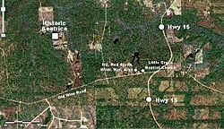
Beatrice is a small place in Stone County, Mississippi. It is called an "unincorporated community." This means it's a group of homes and businesses that is not officially a city or town. Beatrice is about 23 miles (37 km) southeast of Wiggins. It is also part of the larger Gulfport-Biloxi metropolitan area, which is a group of cities and towns that are close together. Beatrice was an important place between 1894 and 1915.
Beatrice is surrounded by the De Soto National Forest. For a long time, it was known for its timber and sawmills. A sawmill is a factory where logs are cut into lumber. After Hurricane Katrina hit, the Beatrice Sawmill helped by giving out portable sawmills. These were used to turn storm-damaged trees into useful wood.
In the Beatrice community, you can find the Little Creek Baptist Church. It is also home to the main office for the Red Creek Wildlife Management Area. This area is a special place where nature and animals are protected.
Learning in Beatrice
The schools in the Beatrice community are part of the Stone County School District. This district makes sure that students in the area get their education.
Getting Around Beatrice
If you want to visit Beatrice, you can use Mississippi Highway 15. This highway helps people travel to and from the community.
 | George Robert Carruthers |
 | Patricia Bath |
 | Jan Ernst Matzeliger |
 | Alexander Miles |


