Latimer, Mississippi facts for kids
Quick facts for kids
Latimer, Mississippi
|
|
|---|---|

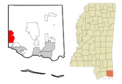
Location of Latimer, Mississippi
|
|
| Country | United States |
| State | Mississippi |
| County | Jackson |
| Area | |
| • Total | 16.28 sq mi (42.18 km2) |
| • Land | 16.28 sq mi (42.17 km2) |
| • Water | 0.00 sq mi (0.00 km2) |
| Elevation | 72 ft (22 m) |
| Population
(2020)
|
|
| • Total | 6,720 |
| • Density | 412.70/sq mi (159.35/km2) |
| Time zone | UTC-6 (Central (CST)) |
| • Summer (DST) | UTC-5 (CDT) |
| ZIP code |
39564
|
| Area code(s) | 228 |
| FIPS code | 28-39520 |
| GNIS feature ID | 0705437 |
Latimer is a community in Jackson County, Mississippi, United States. It is known as a census-designated place (CDP). This means it's an area that the U.S. Census Bureau defines for gathering statistics, but it's not an officially incorporated city or town. Latimer is part of the larger Pascagoula metropolitan area. In 2020, about 6,720 people lived here.
Contents
Latimer's Location and Surroundings
Latimer is located in the western part of Jackson County. To its west, you'll find D'Iberville, which is in Harrison County. To the south, it borders St. Martin.
Interstate 10, a major highway, forms the southern edge of the community. You can get to Latimer from Exit 50 on this interstate. Latimer is about 11 miles (18 km) north of Biloxi. It is also about 27 miles (43 km) northwest of Pascagoula, which is the main city and county seat for Jackson County.
The northern part of Latimer, which is less populated, is inside the De Soto National Forest. This is a large protected forest area. The community covers a total area of about 16.3 square miles (42.3 square kilometers). Only a very small part of this area is water.
Who Lives in Latimer?
| Historical population | |||
|---|---|---|---|
| Census | Pop. | %± | |
| 2020 | 6,720 | — | |
| U.S. Decennial Census | |||
The population of Latimer has been growing. In 2000, about 4,288 people lived there. By 2010, the population had grown to 6,079. The most recent count in 2020 showed 6,720 residents.
Community Makeup in 2020
In 2020, there were 6,720 people living in Latimer. These people made up 2,561 households, with 1,798 of these being families. The community is diverse, with people from many different backgrounds living together.
Schools in Latimer
Students in Latimer attend schools that are part of the Jackson County School District. Even though they live in Latimer, many students go to schools located in the nearby community of St. Martin.
Elementary Schools
- St. Martin North Elementary
- St. Martin East Elementary
- St. Martin Upper Elementary
Middle School
- St. Martin Middle School
High School
- St. Martin High School
See also
 In Spanish: Latimer (Misisipi) para niños
 | Kyle Baker |
 | Joseph Yoakum |
 | Laura Wheeler Waring |
 | Henry Ossawa Tanner |


