Indian River Lagoon facts for kids
Quick facts for kids Indian River Lagoon |
|
|---|---|

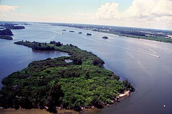
Aerial view of Indian River Lagoon
|
|

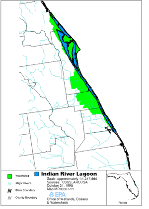
Map of lagoon and surrounding area
|
|
| Country | United States |
| State | Florida |
| Physical characteristics | |
| Main source | Sea level |
| Length | 156 mi (251 km) |
| Basin features | |
| Basin size | 2,187.5 sq mi (5,666 km2) |
The Indian River Lagoon is a special water system on Florida's Atlantic Coast. It is actually made up of three connected lagoons: the Mosquito Lagoon, the Banana River, and the Indian River. This area is one of the most diverse estuaries in the Northern Hemisphere. It is home to over 4,300 different kinds of plants and animals.
The Lagoon is very important for nature. It includes five state parks, four federal wildlife refuges, and a national seashore. The lagoon changes in width from about half a mile to five miles. Its average depth is about four feet.
Contents
A Look Back: History of the Lagoon
How the Lagoon Formed
Many years ago, during the Ice Age, the ocean levels were much lower. The area where the lagoon is now was dry grassland, about 30 miles from the coast. As the glaciers melted, the sea level rose. This trapped water in the low-lying areas, forming the lagoon we see today.
Early People and the Lagoon
Native American tribes lived along the lagoon for a long time. They relied on its fish and shellfish for food. We know this because they left behind large piles of clam, oyster, and mussel shells. These piles are called middens.
European Explorers and New Names
Early Spanish maps called the lagoon the Rio de Ais. This name came from the Ais Indian tribe who lived along Florida's east coast. In 1605, an explorer named Alvero Mexia mapped most of the lagoon. His map showed names like Los Mosquitos (for Mosquito Lagoon), Ulumay Lagoon (for Banana River), and Rio d' Ais (for the northern Indian River).
Changes from Settlers
Later, European settlers arrived. They changed the land around the lagoon to grow crops like pineapples and citrus. They dug many canals, which sent a lot of fresh water into the lagoon. This was about five times more fresh water than it naturally received.
Before railroads, the river was a key way to travel and move goods. In the late 1800s, there were even reports of fish dying in the lagoon. This was caused by gases from the muck at the bottom.
Modern Challenges for the Lagoon
Starting in the 1930s, more cars meant more roads and bridges (causeways) were built across the lagoon. These structures slowed down the water flow. As more people moved to the area, sewage and dirty water from roads (stormwater runoff) began to pollute the lagoon. From 1989 to 2013, the number of people living near the lagoon grew by 50%, reaching 1.6 million.
Where the Indian River Lagoon Flows
The Indian River Lagoon stretches for about 156 miles (251 km). It goes from Ponce de Leon Inlet in Volusia County, Florida, down to Jupiter Inlet in Palm Beach County, Florida. It also includes the area around Cape Canaveral. This lagoon system covers one-third of Florida's East Coast. Most of the lagoon's surface (71%) is within Brevard County.
Lake Okeechobee is connected to the lagoon. Water from the lake can flow into the lagoon through the Okeechobee Waterway and the St. Lucie River. They meet near Sewall's Point.
Parts of the Lagoon System
From north to south, the Indian River Lagoon system includes:
- Mosquito Lagoon: This part goes from Ponce de Leon Inlet to the north end of Merritt Island. It connects to the Indian River through the Haulover Canal.
- Indian River: This is the main body of water. It runs along the western side of Merritt Island, stretching south to St. Lucie Inlet.
- Banana River: This is an offshoot of the Indian River. It forms the eastern shore of Merritt Island.
- Eau Gallie River
- Crane Creek: A 3.3-mile (5.3 km) long river that flows into the Indian River in Melbourne, Florida.
- Turkey Creek Sanctuary: A nature reserve with trails along Turkey Creek.
- Turkey Creek (Indian River): Another tributary of the Indian River in Palm Bay, Florida.
- St. Sebastian River
- Hobe Sound: This is the part of the lagoon from St. Lucie Inlet to Jupiter Inlet.
To help measure water quality, the Marine Resources Council has divided the lagoon into four main sections. These sections are further split into ten smaller areas.
Amazing Nature: Plants and Animals of the Lagoon
The Indian River Lagoon is North America's most diverse estuary. It has over 2,100 types of plants and 2,200 types of animals. This amazing variety is because the lagoon is located near a climate boundary. It is also only about 5 miles (8 km) from the Gulf Stream, which is a strong ocean current. Migratory ocean fish often get swept into the lagoon, adding to its diversity.
Animals of the Lagoon: Fauna
The lagoon is home to 35 species that are listed as threatened or endangered. This is more than any other estuary in North America! About 2,500 different kinds of animals live here. The lagoon is a vital place for many ocean and lagoon fish and shellfish to lay their eggs and for their young to grow. It also has one of the most diverse bird populations in America.
- Manatees: Nearly one-third of the entire manatee population in the United States lives in or travels through the lagoon each year.
- Armadillos: Nine-banded armadillos are one of 34 mammal species found here. They arrived in the 1920s from the southwestern United States.
- Dolphins: Between 200 and 800 Bottlenose dolphins (Tursiops truncatus) also call the Indian River Lagoon home.
- Fish: Popular game fish in the lagoon include Red Drum, Spotted seatrout, Common snook, and Tarpon.
- Birds: You can see many birds like the American kestrel, Reddish egret, and spoonbills.
- Butterflies: The Polydamas swallowtail butterfly is one of the species found here.
- Bioluminescence: In the summer, the lagoon is full of tiny bioluminescent (light-producing) dinoflagellates. In winter, you might see glowing ctenophores (comb jellies).
Plants of the Lagoon: Flora
Seagrass is extremely important for the lagoon's health. It provides food and shelter for many animals. By 1990, the amount of seagrass had grown back to levels seen in 1943. The lagoon also has unique plants like the night-blooming cereus.
How Humans Have Changed the River
Water Diversions and Pollution
In 1916, the St. Lucie Canal (C-44) was built. It sends extra water from Lake Okeechobee into the southern part of the lagoon. This helps prevent flooding around Lake Okeechobee. However, this water often carries too many nutrients from farms. When it enters the lagoon, it can cause harmful algae blooms. These blooms are dangerous for plants, animals, and even people. This problem is still difficult to solve today.
From 1913 to 2013, human activities greatly increased the area of land that drains into the lagoon. This area grew from 572,000 acres to 1.4 million acres. This means more fresh water and nutrients from farms flow into the lagoon, which has harmed its health. Wetlands are natural filters that help clean the water. About 40,000 acres of wetlands were lost due to mosquito control efforts. While some have been restored, the recovery is not complete.
Mangroves are also very important for marine life. They provide nurseries for young fish and protect the coastline. Sadly, between the 1940s and 2013, 85% of the mangroves were removed for housing developments.
Efforts to Protect the Lagoon
In 1990, the Florida Legislature passed the Indian River Lagoon Act. This law required most sewage treatment plants to stop releasing dirty water into the lagoon by 1996. Because of this and a ban on gill nets, some sports fish populations grew back in the 1990s. By 1995, seagrass covered over 100,000 acres (40,000 ha) again.
However, challenges remain. In 2007, people became worried about the lagoon's future, especially in the southern part. Frequent releases of fresh water lowered the saltiness that many fish need. This also led to large algae blooms caused by too many plant fertilizers in the water.
In 2010, a huge amount of pollution entered the lagoon: 3.3 million pounds (1.5 million kg) of nitrogen and 475,000 pounds (215,000 kg) of phosphorus.
Recent Problems and Solutions
In 2011, a massive bloom of tiny plants called phytoplankton caused the loss of 32,000 acres (13,000 ha) of seagrass. In 2012, another "brown tide" bloom polluted the northern lagoon. Local counties have received money to study these unusual blooms and find ways to prevent them.
The number of blue crabs caught has also changed a lot. For example, catches dropped from over 4 million pounds in 1987 to about 390,000 pounds in 2012. Blue crabs need a certain amount of salt in the water to live. Both droughts (which increase salt) and heavy rains (which decrease salt) have hurt the crab population over the years.
By 2013, new algae blooms and seagrass loss had undone all the progress made. In that year, four main problems were identified:
- Too much nitrogen and phosphorus from farm fertilizers.
- Many septic tanks in the area were failing, leaking waste into the ground.
- Muck from construction, farming, and dead plants settled at the bottom of the lagoon. This muck prevents new growth and uses up vital oxygen that marine life needs.
- Invasive species, like the Asian green mussel and Australian spotted jellyfish, were eating native clams and fish larvae.
In 2016, there were an estimated 300,000 septic tanks in the five counties around the lagoon. While sewer plants used to be a bigger problem, the state stopped most of their pollution by 1995.
The worst fish kill happened in March 2016, affecting 30 different species. A brown tide bloom, caused by a type of algae called Aureoumbra lagunensis, was blamed for the low oxygen levels. This algae started growing in a no-motor zone of the Merritt Island National Wildlife Refuge.
By 2018, the lagoon's health was better near the ocean inlets. However, pollution was still a big problem in areas without inlets, like the Mosquito Lagoon, the northern Indian River Lagoon, and the Banana River.
The Lagoon's Importance to the Economy
The Indian River Lagoon is very important for the economy of Florida. Nearly 1 million people live and work in the region around the lagoon. The lagoon helps bring in a lot of money each year:
- Over $300 million from fishing.
- A $2.1 billion citrus industry.
- More than $300 million from boat and marine sales.
In 2007, visitors spent an estimated 3.2 million days enjoying recreation on the lagoon. A report in 2008 estimated that the total value of recreational activities on the Indian River Lagoon for residents and visitors was about $2.1 billion.
 | Dorothy Vaughan |
 | Charles Henry Turner |
 | Hildrus Poindexter |
 | Henry Cecil McBay |

