Barnegat Bay facts for kids
Quick facts for kids Barnegat Bay |
|
|---|---|

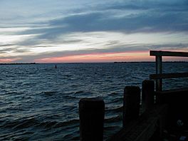
Looking north-northwest from Barnegat Light toward mainland New Jersey.
|
|
| Location | New Jersey |
| Coordinates | 39°51′06″N 74°06′51″W / 39.851709°N 74.114113°W |
| Type | Bay |

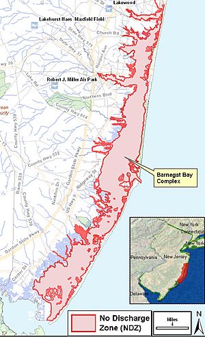
Barnegat Bay is a large, calm body of water along the coast of Ocean County, New Jersey. It is about 42 miles (68 km) long. This bay has slightly salty water, which is called brackish.
A long strip of land called the Barnegat Peninsula (also known as a "barrier island") separates the bay from the Atlantic Ocean. The northern part of Long Beach Island also helps separate the bay from the ocean. These areas are very popular parts of the Jersey Shore.
Several small rivers flow into the bay. These include the Toms River and Metedeconk River. They empty into the bay through small estuaries (where river water mixes with ocean water). Towns like Toms River, Silverton, and Forked River are located along these river estuaries.
The bay connects to the ocean through the Barnegat Inlet. The famous Barnegat Lighthouse stands tall along this inlet. Barnegat Bay is also part of the Atlantic Intracoastal Waterway. This is a water highway for boats that runs along the Atlantic coast. The bay connects to the north via the Point Pleasant Canal. To the south, it connects with Little Egg Harbor through the smaller Manahawkin Bay.
Three bridges cross the bay from the mainland to the peninsula. These include the Mantoloking Bridge and the Thomas A. Mathis and J. Stanley Tunney Bridges. The Barnegat Division of the Edwin B. Forsythe National Wildlife Refuge protects wetlands along the bay's inner southern part. Island Beach State Park is located on the peninsula side of the bay. Many islands within the bay are part of the National Wildlife Refuge or the Sedge Islands State Wildlife Management Area. The northern tip of Long Beach Island is home to the Barnegat Lighthouse State Park.
Contents
Discovering Barnegat Bay's Past
The area around Barnegat Bay was first described in 1609 by Henry Hudson. He called it "a great lake of water." In 1614, Dutch explorers named it "Barendegat," which means "Inlet of the Breakers." This name referred to the bay's often rough and choppy entrance.
During the American Revolutionary War, American privateers (private ships allowed to attack enemy ships) used the bay as a safe hiding spot.
Fishing and Fun on the Bay
Barnegat Bay has always been important for commercial fishing. In the 1800s, the village of Toms River was a major port for whaling (hunting whales).
Today, the bay is still popular for fishing. It has also become a favorite spot for people who enjoy recreational boating. Many people love to sail, kayak, or motorboat on its waters.
Barnegat Bay in Stories and Songs
The famous writer E. B. White wrote a short story called "The Family That Dwelt Apart." He used Barnegat Bay as the setting for this story. It appeared in his book Preposterous Parables. The story was even made into an animated short film by the National Film Board of Canada.
The popular song "My Eyes Adored You" by New Jersey singer Frankie Valli mentions the bay. The lyrics include "walking home every day over Barnegat Bridge and Bay." This song became a number-one hit in 1975.
Protecting the Land Around the Bay
A group called The Trust for Public Land has worked for over 20 years to protect land around Barnegat Bay. They have saved over 1,100 acres (4.5 km²) of land. This group also started the River to Bay Greenway project. Its goal is to create a 70-mile (113 km) path for walking and biking across southern New Jersey. This path will connect the Delaware River to Barnegat Bay.
Challenges Facing Barnegat Bay
In recent years, scientists and local residents have noticed some problems in Barnegat Bay. These include:
- Fish kills: Many fish dying at once.
- Algal blooms: Too much algae growing, which can harm other life.
- Low oxygen levels: Not enough oxygen in the water for fish and other creatures to breathe.
- Loss of habitat: Places where animals live are disappearing.
- Fewer clams: The number of clams in the bay is decreasing.
- More jellyfish: An increase in stinging sea nettle jellyfish.
These issues are mainly caused by high levels of nitrogen. This nitrogen often comes from fertilizer runoff from lawns and farms. The U.S. Environmental Protection Agency (EPA) checks the bay's health regularly. They test the water at four spots, sometimes every week in the summer.
Oyster Creek Nuclear Plant
People have also been concerned about the Oyster Creek Nuclear Generating Station. This power plant was located in Lacey Township, near the bay. It was once the oldest operating nuclear power plant in the United States. It closed down on September 25, 2018. Concerns included the impact of stored radioactive materials and warm water released into the bay.
Islands of Barnegat Bay
Barnegat Bay has several islands. Middle Sedge Island is about 25 acres (10 hectares) in size. Other islands include Little Sedge Island, Northwest Point Island, and Marsh Elder Island. Some of these islands are privately owned, while others belong to the state of New Jersey.
 | Precious Adams |
 | Lauren Anderson |
 | Janet Collins |


