Metedeconk River facts for kids
The Metedeconk River is a river in Ocean County, New Jersey, United States. It flows into Barnegat Bay. A tributary is a smaller stream or river that flows into a larger one.
The Metedeconk River has two main parts: the North Branch and the South Branch. The North Branch is about 22.3 miles (35.9 km) long. The South Branch is about 22.6 miles (36.4 km) long. These two branches meet at a place called Forge Pond.
After Forge Pond, the river gets much wider, sometimes over 1 mile (1.6 km) across. From there, it flows southeast for about 6 miles (9.7 km) until it reaches Barnegat Bay. The river has both fresh water and salty water sections.
The name Metedeconk comes from the original people who lived in this area before Europeans arrived. These were the Metedeconk Tribes. They had two settlements near the river. One was on the north side, near Beaver-dam Creek, in an area now called CedarCroft. The other was on the south side of the river.
Contents
Where the River Meets Other Waters
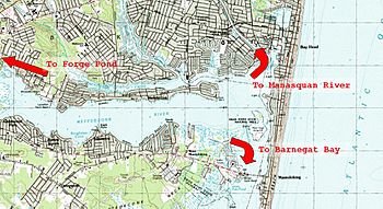
At its eastern end, the Metedeconk River meets the Barnegat Peninsula. This is a narrow strip of land, less than 1 mile (1.6 km) wide. It separates the Metedeconk River from the Atlantic Ocean.
Here, the river connects to Barnegat Bay to the south. It also connects to the Point Pleasant Canal to the north. This canal is man-made and helps boats travel easily. It links the Metedeconk River to the Manasquan River. Without the canal, these two rivers would be separated by about 3 miles (4.8 km) of land. Both the Manasquan River and Barnegat Bay have direct connections to the Atlantic Ocean.
How Ocean Waters Affect the River
The Metedeconk River is a floodplain river, which means it flows through flat land. It is also a tidal river. This means its water levels change with the ocean tides. It connects to the Atlantic Ocean through Barnegat Bay and the Manasquan River.
Most of the ocean water that affects the Metedeconk comes from the Manasquan River, through the Point Pleasant Canal. Before the canal opened in 1926, the Metedeconk and the upper part of Barnegat Bay were mostly fresh water. They did not have tides.
Today, because of the ocean tides, the lower Metedeconk River has brackish (slightly salty) or salty water. This change has greatly affected the plants and animals living there. Sometimes, you might see cream or brown foam on the river's sandy shores or walls. This foam is made of tiny bits of organic material. It builds up naturally from aquatic life when waves move the water.
Hurricane Sandy's Impact
In October 2012, Hurricane Sandy hit New Jersey. The storm was so strong that it opened a new path between Barnegat Bay and the Atlantic Ocean. This happened at the eastern end of the river. The storm destroyed dunes, roads, and houses that used to block the river from the ocean.
So, for a short time, the Metedeconk River was directly open to the Atlantic Ocean. This was near the Route 528 bridge, which was also damaged. By February 2013, repairs to the land and bridge had mostly closed this new opening. The bridge was also reopened for some traffic.
The hurricane caused the river's water to become saltier. It also led to higher levels of certain substances in the water. This happened because water treatment places temporarily stopped working. Scientists are still studying the long-term effects of Hurricane Sandy on the river and its environment.
Different Sections of the River
The Metedeconk River is divided into two main parts. The area west of Forge Pond, where the North and South Branches meet, is called the upper section. The river east of Forge Pond is known as the lower section.
The upper section of the river is popular for people who like to go paddle boating. The lower section is deeper, wider, and has more waves. This makes it a great place for sailboats and powerboats.
Places to Visit Along the River
A well-known spot in the lower Metedeconk is Windward Beach. This is a small beach where people can go for public recreation. In the upper Metedeconk, the river flows through Lake Shenandoah. This is a fresh-water lake with a popular county park nearby.
Why the River is Important to Communities
The Metedeconk River is very important for local wildlife and the people living nearby. It offers a place for fun activities. The river flows through several townships, including Brick, Freehold Township, Howell, Jackson, Wall Township, Lakewood, and Millstone Township.
The Metedeconk River is the main source of drinking water for Brick, Point Pleasant Beach, and Point Pleasant Borough. Because it is so important for drinking water, the state of New Jersey has given it the highest level of protection. It is classified as a Category 1 (C1) River.
Wildlife and Nature
The Metedeconk River has both fresh-water and tidal wetland areas. This means it is home to a wide variety of plants and animals.
Plants and Animals of the Metedeconk
- Plants: Wild rice grows along some parts of the riverbanks.
- Birds: You might see bald eagles flying overhead. Ospreys build nests in nearby trees and towers. They come to the river to catch fish. Parts of the river and its surrounding estuary (where fresh and salt water mix) are protected. They are part of New Jersey’s Edwin B. Forsythe National Wildlife Refuge. This is because the river is very important for migratory birds and waterfowl (birds that live near water).
- Mammals: Mammals found here include river otters and beavers.
- Aquatic Life: The river is full of different kinds of fish and jellyfish. One type of jellyfish is about two inches long. It looks clear during the day but glows blue at night!
 | Lonnie Johnson |
 | Granville Woods |
 | Lewis Howard Latimer |
 | James West |


