Wall Township, New Jersey facts for kids
Quick facts for kids
Wall Township, New Jersey
|
||
|---|---|---|
|
Township
|
||
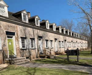
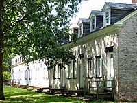
Historic Rowhouses in the Allaire Village of Wall Township
|
||
|
||
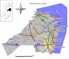
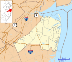
Location of Wall Township in Monmouth County highlighted in yellow (right). Inset map: Location of Monmouth County in New Jersey highlighted in black (left).
<mapframe text="Interactive map of Wall Township, New Jersey" zoom="8" width="250" height="250"> { "type": "ExternalData", "service": "geoshape", "ids": "Q3679383" } </mapframe> |
||
| Country | ||
| State | ||
| County | Monmouth | |
| Incorporated | March 7, 1851 | |
| Named for | Garret D. Wall | |
| Government | ||
| • Type | Township | |
| • Body | Township Committee | |
| Area | ||
| • Total | 31.69 sq mi (82.08 km2) | |
| • Land | 30.66 sq mi (79.41 km2) | |
| • Water | 1.03 sq mi (2.67 km2) 3.25% | |
| Area rank | 80th of 565 in state 7th of 53 in county |
|
| Elevation | 98 ft (30 m) | |
| Population
(2020)
|
||
| • Total | 26,525 | |
| • Estimate
(2023)
|
26,530 | |
| • Rank | 96th of 565 in state 9th of 53 in county |
|
| • Density | 865.2/sq mi (334.1/km2) | |
| • Density rank | 399th of 565 in state 48th of 53 in county |
|
| Time zone | UTC– 05:00 (Eastern (EST)) | |
| • Summer (DST) | UTC– 04:00 (Eastern (EDT)) | |
| ZIP Codes |
07719 – Belmar
07727 – Farmingdale 07731 – Howell 07753 – Neptune 07762 – Spring Lake and Spring Lake Heights 08724 – Brick 08736 – Manasquan 08750 – Sea Girt |
|
| Area code(s) | 732 | |
| FIPS code | 3402576460 | |
| GNIS feature ID | 0882112 | |
Wall Township is a community located in Monmouth County, New Jersey, in the United States. It's a busy area with many highways, right in the middle of the Jersey Shore region. Wall Township is a key transportation spot in Central New Jersey. Many people who live here travel to work in New York City.
As of the 2020 United States census, about 26,525 people lived in Wall Township. This was the highest number of people ever counted in the township. Wall Township officially became a township on March 7, 1851. Over the years, some parts of Wall Township became new towns. These include Belmar, Manasquan, Spring Lake, and Sea Girt.
The township was named after General Garret D. Wall (1783–1850). He was a lawyer and a military leader during the War of 1812. He also served in the United States Senate from 1835 to 1841.
Contents
History of Wall Township
Early Settlements and Buildings
The Greenville Cemetery was started in 1734. The first person buried there was a soldier from the French and Indian War. The Glendola Protestant Bible Church built its first church in 1776. A new church building was dedicated in 1964.
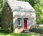
Allaire Village began in 1822. This is when James P. Allaire bought the Howell Works. This place became the biggest bog iron factory in New Jersey by 1836. However, the ironworks closed in 1846.
Allaire Village and State Park
The village and its land were later saved and given to New Jersey. This created Allaire State Park. It was a memorial to Arthur Brisbane, who owned the land last. Today, Allaire Village Inc. helps run "The Historic Village at Allaire."
The Allgor–Barkalow Homestead was built around 1840. It now holds the museum of the Old Wall Historical Society. The Blansingburg schoolhouse opened in 1855. It was moved in 1999 to the museum property to be fixed up.
Wall Township was officially formed in 1851. It was created from parts of Howell Township.
Marconi and Camp Evans
Around 1900, the Marconi Company bought a 93-acre farm. This became the site for their radio equipment. It was used for sending radio messages across the Atlantic Ocean. The Marconi site was closed in 1924.
Later, the United States Army bought the site in 1941. They named it Camp Evans.
Allenwood Hospital and Medical Care
The Allenwood Hospital opened in January 1921. It was a place for people with tuberculosis. In the 1960s, it became part of a nursing home. It was renamed the Geraldine L. Thompson Care Center. In 2016, the nursing home was sold. It is now called Preferred Care at Wall.
Monmouth Executive Airport and Wall Stadium
In 1940, Edward I. Brown used an old World War I tank. He turned it into a bulldozer to clear land for an airport. This airport is now Monmouth Executive Airport. The Brown family sold the airport in 2007.
Wall Stadium Speedway opened in 1950. It is located near the airport. This was the first track where NASCAR champion Richard Petty raced. Plans to close the track in 2020 for houses did not happen. The track is still open today.
Local Landmarks and Schools
The Roadside Diner was brought to its spot in the 1940s. It has been featured in movies and music videos. It appeared in the 1983 movie Baby It's You. It is also on the cover of the 1994 Bon Jovi album Cross Road: 14 Classic Grooves. Bruce Springsteen's 2008 music video for "Girls in Their Summer Clothes" also featured it.
Wall High School opened in September 1959. Wall Intermediate School opened in 1967.
Interstate 195 was extended into Wall Township in 1981. This gave direct access to Trenton.
Geography of Wall Township
Wall Township covers about 31.69 square miles (82.08 km2). Most of this is land, with a small amount of water.
Communities and Places
Allenwood and West Belmar are two communities in Wall Township. Other smaller communities and places include Allaire, Glendola, and New Bedford.
Wreck Pond is a tidal pond on the Atlantic Ocean coast. It is surrounded by Wall Township and nearby towns. The area that drains into Wreck Pond is about 12 square miles (31 km2).
Neighboring Towns
Wall Township shares borders with many other towns. These include Belmar, Brielle, Howell Township, and Manasquan. It also borders Neptune Township, Sea Girt, and Spring Lake. In 2005, a small part of Wall Township became part of Howell Township.
Population and People
| Historical population | |||
|---|---|---|---|
| Census | Pop. | %± | |
| 1860 | 2,283 | — | |
| 1870 | 2,671 | 17.0% | |
| 1880 | 3,829 | 43.4% | |
| 1890 | 3,269 | * | −14.6% |
| 1900 | 3,212 | * | −1.7% |
| 1910 | 3,817 | 18.8% | |
| 1920 | 3,324 | * | −12.9% |
| 1930 | 3,540 | * | 6.5% |
| 1940 | 4,383 | 23.8% | |
| 1950 | 7,386 | 68.5% | |
| 1960 | 11,929 | 61.5% | |
| 1970 | 16,498 | 38.3% | |
| 1980 | 18,952 | 14.9% | |
| 1990 | 20,244 | 6.8% | |
| 2000 | 25,261 | 24.8% | |
| 2010 | 26,164 | 3.6% | |
| 2020 | 26,525 | 1.4% | |
| 2023 (est.) | 26,530 | 1.4% | |
| Population sources: 1860–1920 1860–1870 1870 1880–1890 1890–1910 1910–1930 1900–1990 2000 2010 2020 * = Lost territory in previous decade. |
|||
Population in 2010
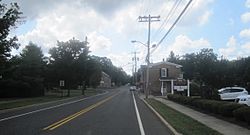
In 2010, the 2010 United States census counted 26,164 people living in Wall Township. There were 10,051 households, which are groups of people living together. The population density was about 853 people per square mile.
Most of the people were White (93.72%). About 2.44% were Black or African American, and 1.61% were Asian. People of Hispanic or Latino background made up 3.47% of the population.
About 23.5% of the people were under 18 years old. The average age in Wall Township was 45.0 years. For every 100 females, there were about 92 males.
Parks and Recreation
The Brick Township Reservoir is partly in Wall Township. It covers 80 acres and has a 1.7-mile trail around it. You can go fishing there. The reservoir can hold a lot of water, which comes from the Metedeconk River.
Wall Township also has about 20 places for outdoor fun. These include public parks, playgrounds, and sports fields. You can go hiking, cycling, fishing, and hunting in these areas. Parts of Allaire State Park and the Edgar Felix Bikeway are in Wall Township.
Government in Wall Township
Local Government
Wall Township is governed by a Township Committee. This committee has five members. They are chosen by voters in elections and serve for three years. Each year, the committee chooses one member to be the mayor. They also choose a deputy mayor. The mayor is not directly elected by the public in this type of government.
As of 2023, the Mayor of Wall Township is Timothy J. Farrell. The Deputy Mayor is Erin M. Mangan. Other committee members are Daniel F. Becht, Timothy J. Clayton, and Kevin P. Orender.
Federal, State, and County Representation
Wall Township is part of the 4th Congressional District for the U.S. Congress. It is also in New Jersey's 30th state legislative district.
New Jersey's Fourth Congressional District is represented by Christopher Smith (R). New Jersey is represented in the United States Senate by Cory Booker (D, Newark, term ends 2021) and Bob Menendez (D, Paramus, 2019). For the 2016–2017 session (Senate, General Assembly), the 30th Legislative District of the New Jersey Legislature is represented in the State Senate by Robert Singer (R, Lakewood Township) and in the General Assembly by Sean T. Kean (R, Wall Township) and Dave Rible (R, Wall Township). Monmouth County is governed by a Board of County Commissioners composed of five members who are elected at-large to serve three-year terms of office on a staggered basis, with either one or two seats up for election each year as part of the November general election. At an annual reorganization meeting held in the beginning of January, the board selects one of its members to serve as director and another as deputy director. As of 2024[update], Monmouth County's Commissioners are:
Director Thomas A. Arnone (R, Neptune City, 2025), Susan M. Kiley (R, Hazlet Township, 2024), Erik Anderson (R, Shrewsbury, 2026), Nick DiRocco (R, Wall Township, 2025), and Deputy Director Ross F. Licitra (R, Marlboro Township, 2026).
Constitutional officers elected on a countywide basis are: Clerk Christine Giordano Hanlon (R, 2025; Ocean Township), Sheriff Shaun Golden (R, 2025; Howell Township) and Surrogate Rosemarie D. Peters (R, 2026; Middletown Township).
Politics and Voting
| Year | Republican | Democratic | Third party | |||
|---|---|---|---|---|---|---|
| No. | % | No. | % | No. | % | |
| 2024 | 10,490 | 60.71% | 6,493 | 37.58% | 295 | 1.71% |
| 2020 | 10,398 | 58.53% | 7,096 | 39.94% | 271 | 1.53% |
| 2016 | 9,412 | 62.67% | 5,092 | 33.90% | 515 | 3.43% |
| 2012 | 8,855 | 63.40% | 4,954 | 35.47% | 158 | 1.13% |
| 2008 | 9,243 | 61.53% | 5,607 | 37.33% | 172 | 1.14% |
| 2004 | 9,434 | 64.73% | 5,013 | 34.39% | 128 | 0.88% |
| 2000 | 7,511 | 58.62% | 4,769 | 37.22% | 532 | 4.15% |
| 1996 | 5,379 | 50.43% | 4,054 | 38.01% | 1,233 | 11.56% |
| 1992 | 5,161 | 52.30% | 2,664 | 26.99% | 2,044 | 20.71% |
As of March 2011, there were 18,809 registered voters in Wall Township. About 33.9% were Republicans. About 17.3% were Democrats. The largest group, 48.8%, were not affiliated with any major party.
In the 2012 presidential election, most voters in Wall Township chose Mitt Romney. In the 2008 election, most voted for John McCain. In the 2004 election, George W. Bush received the most votes.
For the 2013 governor's election, most voters supported Chris Christie. He also won the most votes in the 2009 governor's election.
Education in Wall Township
The Wall Township Public Schools educate students from pre-kindergarten through twelfth grade. In the 2020–21 school year, the district had 3,319 students. There were 377.1 teachers, meaning about 8.8 students per teacher.
The schools in the district include:
- Wall Primary School (PreK)
- Allenwood Elementary School (K-5)
- Central Elementary School (K-5)
- Old Mill Elementary School (K-5)
- West Belmar Elementary School (K-5)
- Wall Intermediate School (grades 6–8)
- Wall High School (grades 9–12)
Historic Village at Allaire
Allaire Village is a living history museum inside Allaire State Park. Before 1650, this land was used by Native Americans. By 1750, a sawmill was built there. The village later became a factory for making iron from bog ore. It was first called Williamsburg Forge. Then it was renamed the Howell Works.
In 1822, James P. Allaire bought the factory. He wanted to create a self-contained community. The iron business closed in 1846. At its busiest, the village supported about 500 people. It was a lively factory town.
Allaire Village became a State Park in June 1957. Governor Robert B. Meyner officially reopened it in May 1958. The museum was created by the New Jersey State Federation of Woman's Clubs in 1958. The village is still being restored. Its buildings and programs help visitors understand New Jersey's industrial past.
Infrastructure and Services
Public Safety
Law Enforcement
The Wall Township Police Department has about 68 officers. They provide police services for the township. Their main office is at 2700 Allaire Road.
Fire Protection
Wall Township has three fire districts. Wall Fire Company #1 was the first volunteer fire company. It started in December 1909. It serves the West Belmar area. Glendola Fire Company started in May 1931. South Wall Fire-Rescue was created in 1946. It protects the south end of town.
The Fire Prevention Bureau handles fire inspections for the whole township.
Emergency Medical Services
Wall Township has three first aid squads. Wall First Aid started in September 1939. Wall Community First Aid Squad began in November 1960. The Wall Township Police Department also has a paid EMS squad. This squad helps the volunteer groups during weekdays.
Transportation
Roads and Highways
Wall Township is a major transportation center. Many important highways cross through it. As of 2010, the township had over 200 miles of roads. Most of these are maintained by the township itself.
Two major highways run through Wall Township: the Garden State Parkway and Interstate 195. Several state routes also pass through, including Route 18, Route 33, Route 34, Route 35, Route 70, and Route 71.
Important county roads include CR 524, CR 547, and CR 549.
Public Transportation
|
Monmouth Executive Airport
|
|||||||||||||||
|---|---|---|---|---|---|---|---|---|---|---|---|---|---|---|---|
| Summary | |||||||||||||||
| Airport type | Public use | ||||||||||||||
| Owner | Wall Herald Corp. | ||||||||||||||
| Serves | Belmar / Farmingdale | ||||||||||||||
| Location | Wall Township, Monmouth County, New Jersey | ||||||||||||||
| Elevation AMSL | 153 ft / 47 m | ||||||||||||||
| Map | |||||||||||||||
| Lua error in Module:Location_map at line 420: attempt to index field 'wikibase' (a nil value). | |||||||||||||||
| Runway | |||||||||||||||
|
|||||||||||||||
| Statistics (2010) | |||||||||||||||
|
|||||||||||||||
|
Source: Federal Aviation Administration
|
|||||||||||||||
Bus Service
Bus service is available from the Garden State Parkway to Lower Manhattan in New York City. The Monmouth Park & Ride is in the township. It offers express bus routes to New York City during busy times.
NJ Transit also provides bus service to Philadelphia on route 317. Local bus service is available on routes 830 and 836.
Train Service
NJ Transit offers passenger train service at nearby stations. These include Belmar, Manasquan, and Spring Lake. Commuter trains run on the North Jersey Coast Line. This line connects to places like Hoboken Terminal and New York Penn Station.
Aviation
Monmouth Executive Airport is located in Wall Township. It handles short-distance flights for private jets. The closest major commercial airports are Trenton-Mercer Airport and Newark Liberty International Airport.
Healthcare
Jersey Shore University Medical Center is a large hospital. It is located in nearby Neptune Township. It serves the northern Jersey Shore region.
Telecommunications
Wall Township uses area codes 732 and 848 for phones. It is also an important spot for undersea internet cables. These cables connect North America to other parts of the world.
Notable People from Wall Township
Many interesting people have lived in or are connected to Wall Township. Here are a few:
- James Peter Allaire (1785–1858), a master mechanic and founder of the first steam engine company in New York City.
- James Avery, a professional chef who appeared on Hell's Kitchen.
- Dara Brown (born circa 1965), a news anchor and actress.
- Kim Clijsters (born 1983), a famous retired professional tennis player.
- Peter Criss (born 1945), a musician from the band KISS.
- Dean Ehehalt (born 1964), the head coach for the Monmouth Hawks baseball team.
- Fletcher (born 1994), a singer-songwriter known for her song "Undrunk".
- George Gelnovatch (born 1965), a former professional soccer player and current coach.
- Emily Grove (born 1991), a singer-songwriter and musician.
- Suzy Hansen (born 1978), a writer whose book was a finalist for a Pulitzer Prize.
- Tom Kain (born 1963), a member of the 1984 U.S. Olympic Soccer Team.
- Sean T. Kean (born 1963), a politician who serves in the New Jersey General Assembly.
- Brian Lynch (born 1978), a retired professional basketball player and coach.
- Guglielmo Marconi (1874–1937), a pioneer in radio technology.
- Gil McDougald (1928–2010), a baseball player for the New York Yankees.
- Jessica Poland (born 1988), a musician known as Charlotte Sometimes.
- Dan Prestup (born 1984), a "World's Fastest Drummer" winner.
- Dave Rible (born 1967), a politician who has served in the New Jersey General Assembly.
- Rusty Schweickart (born 1935), an Apollo 9 astronaut.
- Ned Thomson (born 1953), a politician in the New Jersey General Assembly.
- F. Paul Wilson (born 1946), an author.
- Tim Wright (born 1990), a football player who won the Super Bowl XLIX.
See also
 In Spanish: Municipio de Wall (Nueva Jersey) para niños
 | Roy Wilkins |
 | John Lewis |
 | Linda Carol Brown |


