Sea Girt, New Jersey facts for kids
Quick facts for kids
Sea Girt, New Jersey
|
||
|---|---|---|
|
Borough
|
||
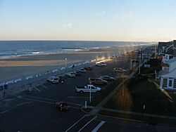
Sunset over the beach at Sea Girt
|
||
|
||
| Motto(s):
Where the Cedars Meet the Sea
|
||
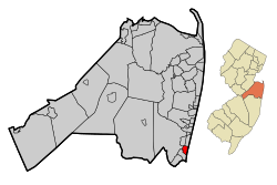
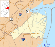
Map of Sea Girt in Monmouth County. Inset: Location of Monmouth County highlighted in the State of New Jersey.
|
||
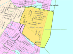
Census Bureau map of Sea Girt, New Jersey
|
||
| Country | ||
| State | ||
| County | Monmouth | |
| Incorporated | May 1, 1917 | |
| Named for | Estate of Comm. Robert F. Stockton | |
| Government | ||
| • Type | Borough | |
| • Body | Borough Council | |
| Area | ||
| • Total | 1.46 sq mi (3.77 km2) | |
| • Land | 1.06 sq mi (2.75 km2) | |
| • Water | 0.40 sq mi (1.03 km2) 27.12% | |
| Area rank | 455th of 565 in state 37th of 53 in county |
|
| Elevation | 13 ft (4 m) | |
| Population
(2020)
|
||
| • Total | 1,866 | |
| • Estimate
(2023)
|
1,841 | |
| • Rank | 491st of 565 in state 43rd of 53 in county |
|
| • Density | 1,759.8/sq mi (679.5/km2) | |
| • Density rank | 311th of 565 in state 39th of 53 in county |
|
| Time zone | UTC−05:00 (Eastern (EST)) | |
| • Summer (DST) | UTC−04:00 (Eastern (EDT)) | |
| ZIP Code |
08750
|
|
| Area code(s) | 732 exchanges: 282, 449, 974 | |
| FIPS code | 3402566330 | |
| GNIS feature ID | 0885388 | |
Sea Girt is a small town, called a borough, located right on the Jersey Shore in Monmouth County, New Jersey. In 2020, about 1,866 people lived here. This was a small increase from 2010, but fewer people than in 2000.
Forbes magazine once named Sea Girt as one of "America's Most Expensive ZIP Codes" in 2012. This means homes here were quite pricey.
Contents
History of Sea Girt
Sea Girt became a borough on March 29, 1917. This happened after people voted for it on May 1, 1917. The town got its name from the property of Commodore Robert F. Stockton. He bought land in the area back in 1853.
On April 1, 2023, a strong wind event, like a small tornado, hit Sea Girt. It was part of a bigger storm system. The winds were very strong, between 110 and 120 miles per hour. The storm blew off a roof and damaged power poles and trees.
Geography and Location
Sea Girt covers about 1.46 square miles (3.77 square kilometers). Most of this area is land, but about 0.40 square miles (1.03 square kilometers) is water.
Nearby Waterways
Wreck Pond is a tidal pond near the Atlantic Ocean. It is surrounded by Sea Girt and other nearby towns. The water from a large area, about 12.8 square miles, flows into Wreck Pond.
Neighboring Towns
Sea Girt shares its borders with several other towns in Monmouth County. These include Manasquan, Spring Lake, Spring Lake Heights, and Wall Township.
Population and People
| Historical population | |||
|---|---|---|---|
| Census | Pop. | %± | |
| 1920 | 110 | — | |
| 1930 | 386 | 250.9% | |
| 1940 | 599 | 55.2% | |
| 1950 | 1,178 | 96.7% | |
| 1960 | 1,798 | 52.6% | |
| 1970 | 2,207 | 22.7% | |
| 1980 | 2,650 | 20.1% | |
| 1990 | 2,099 | −20.8% | |
| 2000 | 2,148 | 2.3% | |
| 2010 | 1,828 | −14.9% | |
| 2020 | 1,866 | 2.1% | |
| 2023 (est.) | 1,841 | 0.7% | |
| Population sources: 1920 1920–1930 1940–2000 2000 2010 2020 |
|||
In 2010, there were 1,828 people living in Sea Girt. Most residents were White. A small number of people were from other racial backgrounds. About 1.64% of the population was Hispanic or Latino.
The average age of people in Sea Girt in 2010 was 53.5 years old. About 19.2% of the population was under 18. Many people, about 29.9%, were 65 years or older.
Education in Sea Girt
Sea Girt has its own school district for younger students. The Sea Girt School District serves students from pre-kindergarten up to eighth grade. All these students attend Sea Girt Elementary School.
Sea Girt Elementary School
Sea Girt Elementary School is a small school. In the 2018–19 school year, it had 125 students. There was about one teacher for every 7.4 students. This school has won the National Blue Ribbon Award twice. This is a very high honor for American schools.
High School Education
After eighth grade, students from Sea Girt go to Manasquan High School. This high school also welcomes students from several other nearby towns. These towns include Avon-by-the-Sea, Belmar, and Spring Lake.
Private School Options
Some students from Sea Girt choose to attend private high schools. Popular choices include Christian Brothers Academy and Ranney School.
Transportation in Sea Girt
Sea Girt has a total of about 17.14 miles of roads. Most of these roads are managed by the town itself.
Main Roads
Route 71 is the most important highway in Sea Girt. It runs north and south along the western side of the borough. This road connects Sea Girt to towns like Manasquan and Spring Lake Heights.
Public Transport Options
NJ Transit provides train service from the nearby Manasquan station. You can take trains on the North Jersey Coast Line. These trains can take you to places like Hoboken Terminal or Penn Station in New York City.
NJ Transit also offers bus service. You can take a bus from Sea Girt to Philadelphia on the 317 route. There's also a local bus, the 830 route, that goes between Asbury Park and Point Pleasant Beach.
Places to Visit
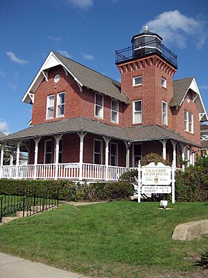
- Sea Girt Light: This historic lighthouse started working on December 10, 1896. It is one of only 20 lighthouses still standing in New Jersey. You can find it at Ocean Avenue and Beacon Boulevard.
- National Guard Militia Museum of New Jersey: This museum in Sea Girt has interesting exhibits. One unique item is the Intelligent Whale, an old experimental submarine.
- Training Facilities: Both the New Jersey State Police and the New Jersey Department of Corrections have their training centers in Sea Girt. The State Police Academy trains new recruits here for 24 weeks. This area was also once a training base for the National Guard.
Climate and Environment
Sea Girt has a humid subtropical climate. This means it has warm, humid summers and mild winters. In summer, a cool sea breeze often blows in the afternoon. However, it can sometimes get very hot and humid.
In winter, it can get very cold and windy. The average snowfall from November to April is about 18 to 24 inches. February usually gets the most snow.
Notable People from Sea Girt
Many interesting people have lived in or are connected to Sea Girt:
- Bill Parcells (born 1941), a famous former NFL coach for teams like the New York Giants.
- Robert F. Stockton (1795–1866), a United States Navy commodore who helped capture California during the Mexican–American War.
- Alex Webster (1931–2012), a football player and coach for the New York Giants.
- William T. Doyle (1926–2024), who served in the Vermont Senate for a very long time.
- Frederick Bernard Lacey (1920–2017), a federal judge in New Jersey.
See also
 In Spanish: Sea Girt para niños
 | Janet Taylor Pickett |
 | Synthia Saint James |
 | Howardena Pindell |
 | Faith Ringgold |


