Farmingdale, New Jersey facts for kids
Quick facts for kids
Farmingdale, New Jersey
|
||
|---|---|---|
|
Borough
|
||
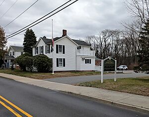
Municipal building
|
||
|
||
| Motto(s):
Today's Town with Yesterday's Touch
|
||
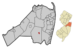
Location of Farmingdale in Monmouth County highlighted in red (left). Inset map: Location of Monmouth County in New Jersey highlighted in orange (right).
|
||
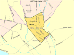
Census Bureau map of Farmingdale, New Jersey
|
||
| Country | ||
| State | ||
| County | Monmouth | |
| Incorporated | April 8, 1903 | |
| Government | ||
| • Type | Borough | |
| • Body | Borough Council | |
| Area | ||
| • Total | 0.52 sq mi (1.35 km2) | |
| • Land | 0.52 sq mi (1.35 km2) | |
| • Water | 0.00 sq mi (0.00 km2) 0.00% | |
| Area rank | 547th of 565 in state 48th of 53 in county |
|
| Elevation | 75 ft (23 m) | |
| Population
(2020)
|
||
| • Total | 1,504 | |
| • Estimate
(2023)
|
1,491 | |
| • Rank | 511th of 565 in state 46th of 53 in county |
|
| • Density | 2,890.0/sq mi (1,115.8/km2) | |
| • Density rank | 224th of 565 in state 27th of 53 in county |
|
| Time zone | UTC−05:00 (Eastern (EST)) | |
| • Summer (DST) | UTC−04:00 (Eastern (EDT)) | |
| ZIP Code |
07727
|
|
| Area code(s) | 732 exchanges: 751, 919, 938 | |
| FIPS code | 3402522950 | |
| GNIS feature ID | 0885218 | |
| Website | ||
Farmingdale is a small town, called a borough, located in Monmouth County, in the state of New Jersey in the United States. In 2020, about 1,504 people lived here. This was an increase from 1,329 people in 2010.
Farmingdale officially became a borough on April 8, 1903. It was created from parts of Howell Township. The town got its name because it is in the middle of an area with many farms.
Contents
Exploring Farmingdale's Location
According to the United States Census Bureau, Farmingdale covers a total area of 0.52 square miles (1.35 square kilometers). All of this area is land.
Farmingdale is completely surrounded by Howell Township. This makes it one of 21 "doughnut towns" in New Jersey. A "doughnut town" is when one town completely wraps around another town.
Who Lives in Farmingdale?
| Historical population | |||
|---|---|---|---|
| Census | Pop. | %± | |
| 1910 | 416 | — | |
| 1920 | 474 | 13.9% | |
| 1930 | 629 | 32.7% | |
| 1940 | 609 | −3.2% | |
| 1950 | 755 | 24.0% | |
| 1960 | 959 | 27.0% | |
| 1970 | 1,148 | 19.7% | |
| 1980 | 1,348 | 17.4% | |
| 1990 | 1,462 | 8.5% | |
| 2000 | 1,587 | 8.5% | |
| 2010 | 1,329 | −16.3% | |
| 2020 | 1,504 | 13.2% | |
| 2023 (est.) | 1,491 | 12.2% | |
| Population sources: 1910–1920 1910 1910–1930 1940–2000 2000 2010 2020 |
|||
Farmingdale's Population in 2010
The 2010 United States census counted 1,329 people living in Farmingdale. There were 547 households, which are groups of people living together.
Most people in Farmingdale were White (about 90%). There were also smaller groups of Black or African American, Native American, and Asian residents. About 7% of the population was Hispanic or Latino.
About 29% of households had children under 18. Many households (45%) were married couples living together. The average household had about 2.43 people.
The median age in Farmingdale was 39.8 years. This means half the people were younger than 39.8 and half were older. About 21.5% of the population was under 18 years old.
Learning in Farmingdale
Farmingdale Schools
The Farmingdale School District is where younger students go to school. Students from pre-kindergarten through eighth grade attend Farmingdale Elementary School.
In the 2022–23 school year, there were 163 students and 24 teachers. This means there were about 6.8 students for every teacher. Farmingdale had one of the smallest school enrollments in New Jersey in 2016–17.
High School Education
Students in ninth through twelfth grades attend Howell High School. This high school is part of the Freehold Regional High School District (FRHSD).
This district serves students from several nearby towns, including Colts Neck, Englishtown, and Howell Township. In 2022–23, Howell High School had over 2,000 students. There were about 15.1 students for every teacher.
Students can also apply to special learning centers within the district. For example, Howell High School hosts the Humanities Learning Center.
Getting Around Farmingdale
Roads and Highways
As of 2010, Farmingdale had about 6.89 miles of roads. Most of these roads (5.30 miles) are maintained by the town itself. The county maintains about 1.59 miles of roads.
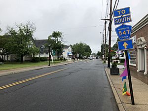
The main roads that go through Farmingdale are County Route 547 and County Route 524. Nearby state highways include Route 33 and Route 34. The closest major highway is Interstate 195.
Local Airport
Monmouth Executive Airport is an airport located just east of Farmingdale. It is used by the public.
Famous People from Farmingdale
Many interesting people have connections to Farmingdale:
- Charles H. Boud (1843–1921) was a politician who served in the New Jersey government.
- Billy Brown (born 1944) is a singer and songwriter. He was an original member of the R&B group, Ray, Goodman & Brown.
- George Fischbeck (1922–2015) was a well-known television weatherman.
- Jim Gary (1939–2006) was a sculptor famous for making large, colorful dinosaur art from old car parts.
- Chris Hill (born 1994) is a soccer player who played as a defender.
- Herman Hill (1945–1970) was a professional baseball outfielder for the Minnesota Twins.
- Janis Ian (born 1951) is a singer-songwriter and author. She is known for her songs "Society's Child" and "At Seventeen."
- Denny Walling (born 1954) was a Major League Baseball player in the 1980s, mostly for the Houston Astros.
See also
 In Spanish: Farmingdale (Nueva Jersey) para niños
 | Bayard Rustin |
 | Jeannette Carter |
 | Jeremiah A. Brown |


