
Shrewsbury, New Jersey facts for kids
Quick facts for kids
Shrewsbury, New Jersey
|
||
|---|---|---|
|
Borough
|
||

Public park near Shrewsbury's municipal building
|
||
|
||

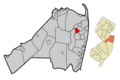
Location of Shrewsbury in Monmouth County highlighted in red (left). Inset map: Location of Monmouth County in New Jersey highlighted in orange (right).
|
||

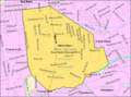
Census Bureau map of Shrewsbury, New Jersey
<mapframe text="Interactive map of Shrewsbury, New Jersey" zoom="8" width="250" height="250"> { "type": "ExternalData", "service": "geoshape", "ids": "Q1084814" } </mapframe> |
||

Shrewsbury, New Jersey
Location in Monmouth County, New Jersey

Shrewsbury, New Jersey
Location in New Jersey

Shrewsbury, New Jersey
Location in the United States
|
||
| Country | ||
| State | ||
| County | Monmouth | |
| Incorporated | May 11, 1926 | |
| Named for | Shrewsbury, England | |
| Government | ||
| • Type | Borough | |
| • Body | Borough Council | |
| Area | ||
| • Total | 2.19 sq mi (5.67 km2) | |
| • Land | 2.16 sq mi (5.60 km2) | |
| • Water | 0.03 sq mi (0.07 km2) 1.32% | |
| Area rank | 395th of 565 in state 27th of 53 in county |
|
| Elevation | 46 ft (14 m) | |
| Population
(2020)
|
||
| • Total | 4,184 | |
| • Estimate
(2023)
|
4,149 | |
| • Rank | 408th of 565 in state 38th of 53 in county |
|
| • Density | 1,936.6/sq mi (747.7/km2) | |
| • Density rank | 298th of 565 in state 37th of 53 in county |
|
| Time zone | UTC−05:00 (Eastern (EST)) | |
| • Summer (DST) | UTC−04:00 (Eastern (EDT)) | |
| ZIP Code |
07702
|
|
| Area code(s) | 732 | |
| FIPS code | 3402567350 | |
| GNIS feature ID | 885395 | |

Shrewsbury is a small town, called a borough, in eastern Monmouth County, New Jersey. It's located in the middle of the northern Shore area. Shrewsbury is a "bedroom community," which means many people who live here travel to work in bigger cities like New York City.
In 2020, about 4,184 people lived in Shrewsbury. This was the highest number of people ever counted in the town. Shrewsbury became a borough on May 11, 1926. It was created from parts of Shrewsbury Township. The borough is named after Shrewsbury, a town in England.
Contents
History of Shrewsbury
Shrewsbury was once part of a very old land grant called the Navesink Patent. This grant was given in 1665 when the area of East Jersey was formed. It included Shrewsbury and other historic towns like Freehold and Middletown.
When Shrewsbury was first set up in 1693, it was huge! It covered almost 1,000 square miles (2,600 km2). This area stretched from the Navesink River in the north all the way down to what is now Ocean County in the south. It also went from the Atlantic Ocean in the east to the current border of Monmouth County in the west.
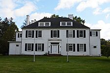
Over time, different towns broke away from this large area. The first was Stafford Township in 1750, which took a big part of modern-day Ocean County. The Parker Homestead is one of the oldest buildings in New Jersey. It was built by some of the first settlers in the area. Many early settlers came from places like Long Island, Rhode Island, and Massachusetts.
Shrewsbury Township was first formed in 1693. Then, Shrewsbury Borough officially separated from Shrewsbury Township on May 11, 1926.
Geography of Shrewsbury
Shrewsbury Borough covers a total area of about 2.19 square miles (5.67 km2). Most of this is land, about 2.16 square miles (5.60 km2). A small part, 0.03 square miles (0.07 km2), is water.
The borough shares borders with several other towns in Monmouth County. These include Eatontown, Little Silver, Oceanport, Red Bank, Shrewsbury Township, and Tinton Falls.
Before 1926, Shrewsbury Borough was part of Shrewsbury Township. This township used to be much larger, covering most of Monmouth and Ocean counties. Over the years, it became much smaller, less than one square mile.
Population and People

| Historical population | |||
|---|---|---|---|
| Census | Pop. | %± | |
| 1930 | 857 | — | |
| 1940 | 1,058 | 23.5% | |
| 1950 | 1,613 | 52.5% | |
| 1960 | 3,222 | 99.8% | |
| 1970 | 3,315 | 2.9% | |
| 1980 | 2,962 | −10.6% | |
| 1990 | 3,096 | 4.5% | |
| 2000 | 3,590 | 16.0% | |
| 2010 | 3,809 | 6.1% | |
| 2020 | 4,184 | 9.8% | |
| 2023 (est.) | 4,149 | 8.9% | |
| Population sources: 1930 1940–2000 2000 2010 2020 |
|||
In 2010, there were 3,809 people living in Shrewsbury. There were 1,261 households, which are groups of people living together. Most households (71.5%) were married couples. About 40.7% of households had children under 18.
The population included people of different backgrounds. About 95.62% were White, 0.66% were Black or African American, and 2.13% were Asian. About 2.49% of the population were Hispanic or Latino.
The average age of people in Shrewsbury was 44.3 years old. About 27% of the population was under 18.
Economy and Shopping
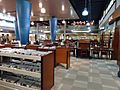
The Grove at Shrewsbury is a popular shopping center in the borough. It's located on Route 35. The Grove opened in 1988 and has many stores.
Some of the well-known stores there include Brooks Brothers, Anthropologie, J. Crew, Williams Sonoma, and Banana Republic. The Grove is a central spot for shopping and meeting up in Shrewsbury. It's also close to the downtown area of Red Bank, another popular place.
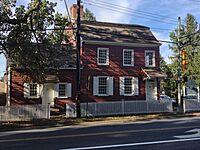
Historic District
|
Shrewsbury Historic District
|
|

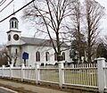
Christ Church along Route 35
|
|
| Location | Broad Street and Sycamore Avenue |
|---|---|
| Area | 85 acres (34 ha) |
| Architectural style | Queen Anne, Dutch Colonial |
| NRHP reference No. | 78001779 |
| Significant dates | |
| Added to NRHP | July 17, 1978 |
The Shrewsbury Historic District is a special area along Broad and Sycamore Streets. It's important because of its old buildings and history. This village was a key travel route during colonial times.
The district was added to the National Register of Historic Places in 1978. This means it's recognized for its important architecture and religious history. It includes 47 historic buildings. Among them are three churches, the Allen House, and the Wardell House.
-
Allen House
-
Wardell House


Education in Shrewsbury

Students in Shrewsbury attend public schools run by the Shrewsbury Borough School District. This district has one school, the Shrewsbury Borough School. It serves students from pre-kindergarten up to eighth grade. In the 2022–23 school year, about 465 students attended this school.
For high school, students go to Red Bank Regional High School. This school serves students from Shrewsbury, Little Silver, and Red Bank. It also has special programs for students from other towns. Students can even attend for its performing arts program if they are accepted.
There are also private school options in the area. These include Christian Brothers Academy and Red Bank Catholic High School. These are Catholic schools run by the Roman Catholic Diocese of Trenton.
Transportation
_at_Monmouth_County_Route_13A_(Sycamore_Avenue)_in_Shrewsbury,_Monmouth_County,_New_Jersey.jpg)
Shrewsbury has about 21.50 miles (34.60 km) of roads. Most of these roads are maintained by the borough itself.
Route 35 is the main road that goes north and south through Shrewsbury. CR 520 runs east and west along the northern edge of the borough.
The Garden State Parkway is a major highway nearby. You can get to it from neighboring Tinton Falls or via CR 520 in Middletown.
For public transportation, NJ Transit offers train service. You can catch a train at the Little Silver station. The North Jersey Coast Line provides service to places like Hoboken Terminal and Penn Station in New York City. NJ Transit also has local bus service on routes 831 and 832.
Famous People from Shrewsbury
Many interesting people have lived in or are connected to Shrewsbury:
- Alfred N. Beadleston (1912–2000) was a politician who served as mayor of Shrewsbury. He also led the New Jersey General Assembly and Senate.
- Alisyn Camerota (born 1966) is a TV news anchor. She is known for her work on CNN and Fox News.
- Kimberly Eulner (born 1966) is the current mayor of Shrewsbury. She also served in the New Jersey General Assembly.
- Jake Kalish (born 1991) is a professional baseball pitcher.
- Ryan Kalish (born 1988) is a professional baseball outfielder who played for the Chicago Cubs.
- John Eatton Le Conte (1784–1860) was a naturalist, someone who studies nature.
- Richard Lippincott (1615–1683) was an early English Quaker settler in Shrewsbury.
- Greg Montgomery (born 1964) was a professional football punter for teams like the Houston Oilers.
- Michael J. Panter (born 1969) was a politician who served in the New Jersey General Assembly.
- John Lloyd Stephens (1805–1852) was an explorer and writer. He helped rediscover the ancient Maya civilization.
Images for kids
-
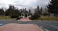
Public park near Shrewsbury's municipal building
-
Seal of Shrewsbury
-
Location of Shrewsbury in Monmouth County highlighted in red (left). Inset map: Location of Monmouth County in New Jersey highlighted in orange (right).
-
Census Bureau map of Shrewsbury, New Jersey
-
Christ Church along Route 35
-
The Monmouth County Library is in Shrewsbury.
-

Route 35 in Shrewsbury
See also
 In Spanish: Shrewsbury (Nueva Jersey) para niños
