Eatontown, New Jersey facts for kids
Quick facts for kids
Eatontown, New Jersey
|
||
|---|---|---|
|
Borough
|
||
|
|
||
|
||
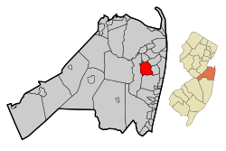
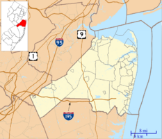
Location of Eatontown in Monmouth County highlighted in red (left). Inset map: Location of Monmouth County in New Jersey highlighted in orange (right).
|
||
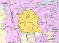
Census Bureau map of Eatontown, New Jersey
|
||
| Country | ||
| State | ||
| County | Monmouth | |
| Incorporated | April 4, 1873 as township | |
| Incorporated | March 8, 1926 as borough | |
| Named for | Thomas Eaton | |
| Government | ||
| • Type | Borough | |
| • Body | Borough Council | |
| Area | ||
| • Total | 5.89 sq mi (15.26 km2) | |
| • Land | 5.84 sq mi (15.13 km2) | |
| • Water | 0.05 sq mi (0.13 km2) 0.87% | |
| Area rank | 260th of 565 in state 18th of 53 in county |
|
| Elevation | 52 ft (16 m) | |
| Population
(2020)
|
||
| • Total | 13,597 | |
| • Estimate
(2023)
|
13,496 | |
| • Rank | 190th of 565 in state 15th of 53 in county |
|
| • Density | 2,327.9/sq mi (898.8/km2) | |
| • Density rank | 266th of 565 in state 32nd of 53 in county |
|
| Time zone | UTC−05:00 (Eastern (EST)) | |
| • Summer (DST) | UTC−04:00 (Eastern (EDT)) | |
| ZIP Codes |
07724, 07799
|
|
| Area code(s) | 732 | |
| FIPS code | 3402519840 | |
| GNIS feature ID | 0885202 | |
Eatontown is a small town, called a borough, located in Monmouth County, New Jersey. In 2020, about 13,597 people lived here. This was a small increase from the 2010 population.
The area became Eatontown Township on April 4, 1873. It was formed from parts of Ocean Township and Shrewsbury Township. Later, some parts became new towns like West Long Branch and Oceanport. Eatontown officially became a borough on March 8, 1926. The town is named after Thomas Eaton, an early settler who built a mill around 1670.
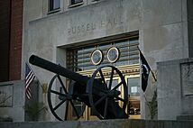
Fort Monmouth, a base for the United States Army, was in Eatontown from 1917 until it closed in 2011. It was an important center for army communications. The United States Military Academy Preparatory School was also located there. This school helped students get ready to attend the United States Military Academy at West Point.
In the middle of Eatontown, you'll find the Monmouth Mall. It has many stores, restaurants, and a large movie theater.
Contents
Discover Eatontown's Past
Eatontown has a rich history that you can learn about in the book Eatontown and Fort Monmouth.
Early Beginnings: Thomas Eaton's Mill
In 1670, Thomas Eaton, the person the town is named after, explored the area. He built a grist mill in what is now Wampum Lake Park. A grist mill grinds grain into flour.
Celebrating 350 Years
Eatontown planned to celebrate its 350th anniversary in 2020. However, many events were postponed because of the COVID-19 pandemic.
Exploring Eatontown's Geography
Eatontown covers about 5.89 square miles (15.26 square kilometers). Most of this area is land, with a small amount of water.
Neighboring Towns
Eatontown shares its borders with several other towns in Monmouth County. To the north is Shrewsbury. Oceanport is to the northeast, and West Long Branch is to the east. To the south, you'll find Ocean Township, and Tinton Falls is to the west.
Understanding Eatontown's Population
| Historical population | |||
|---|---|---|---|
| Census | Pop. | %± | |
| 1880 | 2,642 | — | |
| 1890 | 2,953 | 11.8% | |
| 1900 | 3,021 | 2.3% | |
| 1910 | 2,076 | −31.3% | |
| 1920 | 2,682 | 29.2% | |
| 1930 | 1,938 | −27.7% | |
| 1940 | 1,758 | −9.3% | |
| 1950 | 3,044 | 73.2% | |
| 1960 | 10,334 | 239.5% | |
| 1970 | 14,619 | 41.5% | |
| 1980 | 12,703 | −13.1% | |
| 1990 | 13,800 | 8.6% | |
| 2000 | 14,008 | 1.5% | |
| 2010 | 12,709 | −9.3% | |
| 2020 | 13,597 | 7.0% | |
| 2023 (est.) | 13,496 | 6.2% | |
| Population sources: 1880–1920 1880–1890 1890–1910 1910–1930 1940–2000 2000 2010 2020 |
|||
Population in 2010
In 2010, Eatontown had 12,709 people living in 5,319 households. The average household had about 2.32 people. About 20.7% of the population was under 18 years old. The median age was 39.6 years.
Learning in Eatontown: Schools and Education
Eatontown has public schools for students from pre-kindergarten through eighth grade. These schools are part of the Eatontown Public Schools district.
Eatontown Public Schools
The district has four schools. There are three elementary schools and one middle school.
- Meadowbrook Elementary School serves students in PreK through 1st grade.
- Woodmere Elementary School teaches students in PreK and grades 2-4.
- Margaret L. Vetter Elementary School has students in PreK and grades 5-6.
- Memorial Middle School is for students in 7th and 8th grades.
High School Education
Students in ninth through twelfth grades attend Monmouth Regional High School. This high school is located in Tinton Falls. It also serves students from Shrewsbury Township and Tinton Falls.
Specialized Education
Eatontown is also home to Hawkswood School. This school helps students with complex disabilities, including autism, get the education they need.
Getting Around Eatontown: Transportation
Eatontown has a good network of roads and public transportation options.
Major Roads and Highways
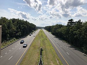
Several important state highways run through Eatontown. These include Route 18, Route 35, and Route 36. Route 71 also passes through the northern part of the borough. You can also find major county roads like CR 537 and CR 547.
The Garden State Parkway, a very large highway, is easily reached near Eatontown. You can get on it at Exit 105 in nearby Tinton Falls.
Public Bus Service
NJ Transit provides local bus services in Eatontown. These include the 831 and 832 bus routes.
Complete Streets Initiative
Eatontown has a "Complete Streets" plan. This plan aims to make the community safe and easy for everyone to walk and bike. This includes people of all ages and abilities.
Famous People from Eatontown
Many interesting people have connections to Eatontown. Here are a few:
- Preet Bharara (born 1968), a former important lawyer for the United States government.
- Charles W. Billings (1866–1928), a politician and a gold medalist in shooting at the 1912 Summer Olympics.
- Joe Bravo (born 1971), a professional horse racing jockey.
- Herm Edwards (born 1954), a football analyst and former NFL head coach.
- June Elvidge (1893–1965), a film actress.
- Melissa Reeves (born 1967), an actress known for her role on Days of Our Lives.
- Kevin Ritz (born 1965), a former professional baseball pitcher.
- Cindy Lee Van Dover (born 1954), an oceanographer who studies the ocean's living things and environment.
See also
 In Spanish: Eatontown para niños
 | Tommie Smith |
 | Simone Manuel |
 | Shani Davis |
 | Simone Biles |
 | Alice Coachman |


