
West Long Branch, New Jersey facts for kids
Quick facts for kids
West Long Branch, New Jersey
|
||
|---|---|---|
|
Borough
|
||

|
||
|
||

Location of West Long Branch in Monmouth County highlighted in red (left). Inset map: Location of Monmouth County in New Jersey highlighted in orange (right).
|
||

Census Bureau map of West Long Branch, New Jersey
|
||

West Long Branch, New Jersey
Location in Monmouth County, New Jersey

West Long Branch, New Jersey
Location in New Jersey

West Long Branch, New Jersey
Location in the United States
|
||
| Country | ||
| State | ||
| County | Monmouth | |
| Incorporated | May 5, 1908 | |
| Government | ||
| • Type | Borough | |
| • Body | Borough Council | |
| Area | ||
| • Total | 2.89 sq mi (7.49 km2) | |
| • Land | 2.86 sq mi (7.40 km2) | |
| • Water | 0.04 sq mi (0.09 km2) 1.25% | |
| Area rank | 342nd of 565 in state 23rd of 53 in county |
|
| Elevation | 26 ft (8 m) | |
| Population
(2020)
|
||
| • Total | 8,587 | |
| • Estimate
(2023)
|
8,555 | |
| • Rank | 279th of 565 in state 22nd of 53 in county |
|
| • Density | 3,006.7/sq mi (1,160.9/km2) | |
| • Density rank | 217th of 565 in state 25th of 53 in county |
|
| Time zone | UTC−05:00 (Eastern (EST)) | |
| • Summer (DST) | UTC−04:00 (Eastern (EDT)) | |
| ZIP Code |
07764
|
|
| Area code(s) | 732 and 908 (cell) | |
| FIPS code | 3402579310 | |
| GNIS feature ID | 0885437 | |
| Website | ||


West Long Branch is a small town, called a borough, located in the Jersey Shore area of Monmouth County, New Jersey. In 2020, 8,587 people lived here. This was the highest number of people ever counted in the borough. West Long Branch is also home to Monmouth University.
Contents
History of West Long Branch
Before it was called West Long Branch, this area had different names. In the 1700s, it was known as Mechanicsville. After the Civil War, in the 1870s, it was called Branchburg. The name West Long Branch first appeared in a map of Monmouth County in 1889. It likely got its name because it was close to a part of the Shrewsbury River.
In 1908, people living in the West Long Branch part of Eatontown felt they were not getting enough back from their taxes. They asked to separate from Eatontown. Eatontown did not want this because West Long Branch had large estates that paid a lot of taxes.
However, a law was passed by the New Jersey Legislature on April 7, 1908. The Monmouth County Board of Chosen Freeholders then allowed an election. On May 5, 1908, people in West Long Branch voted to separate. The borough's name comes from Long Branch, which was named after a "long branch" of the Shrewsbury River.
Geography and Location
West Long Branch covers about 2.89 square miles (7.49 square kilometers). Most of this area is land, with a small part being water.
A community called Norwood Park is located partly or fully within the borough.
West Long Branch shares its borders with other towns in Monmouth County:
Local Climate
West Long Branch has a climate with warm summers and cool winters. It gets a good amount of rain throughout the year.
| Climate data for West Long Branch | |||||||||||||
|---|---|---|---|---|---|---|---|---|---|---|---|---|---|
| Month | Jan | Feb | Mar | Apr | May | Jun | Jul | Aug | Sep | Oct | Nov | Dec | Year |
| Mean daily maximum °C (°F) | 4.3 (39.7) |
5.7 (42.3) |
9.3 (48.7) |
15.1 (59.2) |
19.9 (67.8) |
24.9 (76.8) |
27.8 (82.0) |
27.1 (80.8) |
23.7 (74.7) |
18 (64) |
12.3 (54.1) |
7.3 (45.1) |
16.3 (61.3) |
| Daily mean °C (°F) | 0.7 (33.3) |
1.6 (34.9) |
5.1 (41.2) |
10.6 (51.1) |
15.9 (60.6) |
21.1 (70.0) |
24.3 (75.7) |
23.7 (74.7) |
20.5 (68.9) |
14.6 (58.3) |
8.8 (47.8) |
4 (39) |
12.6 (54.6) |
| Mean daily minimum °C (°F) | −2.1 (28.2) |
−1.5 (29.3) |
1.8 (35.2) |
7.2 (45.0) |
12.7 (54.9) |
18.1 (64.6) |
21.3 (70.3) |
21 (70) |
17.8 (64.0) |
11.9 (53.4) |
6.2 (43.2) |
1.5 (34.7) |
9.7 (49.4) |
| Average rainfall mm (inches) | 99 (3.9) |
88 (3.5) |
117 (4.6) |
98 (3.9) |
97 (3.8) |
98 (3.9) |
93 (3.7) |
108 (4.3) |
101 (4.0) |
107 (4.2) |
85 (3.3) |
119 (4.7) |
1,210 (47.8) |
| Average rainy days | 7 | 7 | 8 | 8 | 8 | 8 | 8 | 8 | 7 | 7 | 6 | 8 | 90 |
| Average relative humidity (%) | 64 | 62 | 64 | 65 | 70 | 72 | 70 | 71 | 72 | 69 | 68 | 67 | 68 |
| Source: Climate-Data.org, altitude: 10 | |||||||||||||
Population and People
| Historical population | |||
|---|---|---|---|
| Census | Pop. | %± | |
| 1910 | 879 | — | |
| 1920 | 1,686 | 91.8% | |
| 1930 | 1,686 | 0.0% | |
| 1940 | 2,030 | 20.4% | |
| 1950 | 2,739 | 34.9% | |
| 1960 | 5,337 | 94.9% | |
| 1970 | 6,845 | 28.3% | |
| 1980 | 7,380 | 7.8% | |
| 1990 | 7,690 | 4.2% | |
| 2000 | 8,258 | 7.4% | |
| 2010 | 8,097 | −1.9% | |
| 2020 | 8,587 | 6.1% | |
| 2023 (est.) | 8,555 | 5.7% | |
| Population sources: 1910–1920 1910 1910–1930 1940–2000 2000 2010 2020 |
|||
In 2010, the 2010 United States census counted 8,097 people living in West Long Branch. There were 2,384 households, which are groups of people living together.
Most of the people were White (94.45%). There were also Black or African American (2.21%), Asian (1.19%), and people from other backgrounds. About 5% of the population was Hispanic or Latino.
The average household had about 2.77 people. The average family had about 3.23 people.
About 19.6% of the people were under 18 years old. The median age was 32.4 years. This means half the people were younger than 32.4 and half were older.
Education in West Long Branch

The West Long Branch Public Schools educate students from pre-kindergarten through eighth grade. Students from nearby towns like Allenhurst, Interlaken, and Loch Arbour also attend these schools.
The district has two schools:
- Betty McElmon Elementary School: For students in pre-kindergarten through fourth grade.
- Frank Antonides School: For students in fifth through eighth grades.
For high school, students attend Shore Regional High School. This school is located in West Long Branch. It also serves students from Monmouth Beach, Oceanport, and Sea Bright.
Shore Regional High School had about 613 students in the 2021-2022 school year. West Long Branch has four of the nine seats on the high school's board of education.
Monmouth University
Monmouth University is a private university that started in 1933. It has a large campus of 155 acres (0.63 square kilometers). About 5,600 students attend the university.
A famous building on campus is The Great Hall at Shadow Lawn. It is a National Historic Landmark. This building was even used in the 1982 movie Annie.
Getting Around West Long Branch
_in_West_Long_Branch,_Monmouth_County,_New_Jersey.jpg)
West Long Branch has many roads. The borough maintains most of them. Two main roads, Route 36 and Route 71, meet in the borough.
Public Transportation Options
NJ Transit offers local bus services on routes 831 and 837.
For train service, the closest station is the Long Branch station. From there, you can take the North Jersey Coast Line train. This line connects to places like Hoboken Terminal and Penn Station in New York City.
Famous People from West Long Branch
Many interesting people have lived in or are connected to West Long Branch. Here are a few:
- Jake Areman (born 1996): A soccer player for the Tampa Bay Rowdies.
- Holly Black (born 1971): An author known for the Spiderwick book series.
- Chester Bowman (1901–1936): A sprinter who competed in the 1924 Summer Olympics.
- Clarkson Sherman Fisher (1921–1997): A federal judge who was also a council member in West Long Branch.
- Jon Herington (born 1954): A jazz guitarist.
- Ryan McCormick (born 1991): A professional golfer.
- Arthur Pryor (1870–1942): A famous trombone player and bandleader. He wrote many songs, including "The Whistler and His Dog."
- Jack Yonezuka (born 2003): A judo athlete who competed in the 2024 Summer Olympics.
- Jimmy Zoppi (born 1954): A musician and voice actor.
Images for kids
-

The Murry Guggenheim House, a historic building.
-
The official seal of West Long Branch.
-
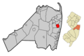
Map showing West Long Branch's location in Monmouth County.
-
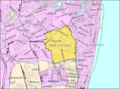
A map of West Long Branch from the Census Bureau.
See also
 In Spanish: West Long Branch para niños
