Interlaken, New Jersey facts for kids
Quick facts for kids
Interlaken, New Jersey
|
||
|---|---|---|
|
Borough
|
||

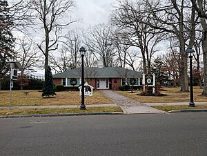
Interlaken Municipal Offices
|
||
|
||

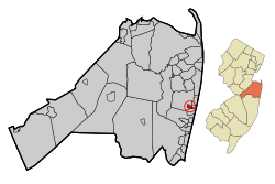
Location of Interlaken in Monmouth County circled and highlighted in red (left). Inset map: Location of Monmouth County in New Jersey highlighted in orange (right).
|
||

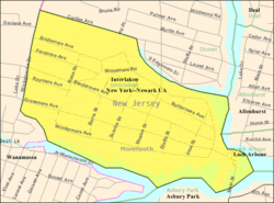
Census Bureau map of Interlaken, New Jersey
|
||
| Country | ||
| State | ||
| County | Monmouth | |
| Incorporated | May 3, 1922 | |
| Named for | Interlaken, Switzerland | |
| Government | ||
| • Type | Borough | |
| • Body | Borough Council | |
| Area | ||
| • Total | 0.39 sq mi (1.01 km2) | |
| • Land | 0.33 sq mi (0.86 km2) | |
| • Water | 0.06 sq mi (0.15 km2) 14.62% | |
| Area rank | 550th of 565 in state 49th of 53 in county |
|
| Elevation | 16 ft (5 m) | |
| Population
(2020)
|
||
| • Total | 828 | |
| • Estimate
(2023)
|
817 | |
| • Rank | 539th of 565 in state 50th of 53 in county |
|
| • Density | 2,499.4/sq mi (965.0/km2) | |
| • Density rank | 251st of 565 in state 31st of 53 in county |
|
| Time zone | UTC−05:00 (Eastern (EST)) | |
| • Summer (DST) | UTC−04:00 (Eastern (EDT)) | |
| ZIP Code |
07712
|
|
| Area code(s) | 732 | |
| FIPS code | 3402534200 | |
| GNIS feature ID | 0885261 | |
| Website | ||
Interlaken is a small borough located in the Jersey Shore area of New Jersey. It is part of Monmouth County. In 2020, about 828 people lived there. This was a small increase from the 820 people counted in 2010.
Interlaken became an official borough on May 3, 1922. This happened after people in the area voted to approve it. It was created from parts of Ocean Township. Interlaken is also known as a "dry town," which means that stores and restaurants are not allowed to sell alcohol.
Contents
Discovering Interlaken's Past
The land where Interlaken now stands was first bought in 1667. Gavin Drummond bought it from the Lenape Native Americans. Later, this area became part of Ocean Township. Many other towns, like Asbury Park and Long Branch, were once part of Ocean Township too.
How Interlaken Got Its Name
A doctor from Boston named Francis Weld bought a large piece of land here. He called it Interlaken Farm. He named it after a place in Switzerland called Interlaken. That Swiss town is located between two lakes. Dr. Weld thought his farm was similar because it was between two parts of Deal Lake.
In 1890, Dr. Weld wanted to turn his farm into a neighborhood. He planned streets named after English lakes and islands. At first, this idea didn't fully take off. But in 1905, a new company helped the community start to grow.
Becoming an Official Borough
Interlaken officially became a borough on March 11, 1922. This decision was made after a special vote on May 3, 1922. The first mayor and council members started their jobs on June 26, 1922.
Interlaken was always meant to be a place just for homes. For a long time, it was the only town in New Jersey without any businesses. However, in 1992, a day-care center opened. This was allowed under a state law for child care places.
Exploring Interlaken's Geography
Interlaken is a small borough. It covers about 0.39 square miles (1.01 square kilometers) in total. Most of this area is land, about 0.33 square miles (0.86 square kilometers). The rest is water, which makes up about 14.62% of the borough.
Interlaken shares its borders with a few other towns in Monmouth County. These include Allenhurst, Asbury Park, Loch Arbour, and Ocean Township.
A big part of Interlaken's geography is Deal Lake. This lake covers about 158 acres. It is managed by the Deal Lake Commission, which started in 1974. Seven different towns share the lake's shoreline. This shoreline stretches for about 27 miles (43 kilometers).
Interlaken's Population Over Time
| Historical population | |||
|---|---|---|---|
| Census | Pop. | %± | |
| 1930 | 545 | — | |
| 1940 | 787 | 44.4% | |
| 1950 | 833 | 5.8% | |
| 1960 | 1,168 | 40.2% | |
| 1970 | 1,182 | 1.2% | |
| 1980 | 1,037 | −12.3% | |
| 1990 | 910 | −12.2% | |
| 2000 | 900 | −1.1% | |
| 2010 | 820 | −8.9% | |
| 2020 | 828 | 1.0% | |
| 2023 (est.) | 817 | −0.4% | |
| Population sources:1930 1940–2000 2000 2010 2020 |
|||
In 2010, Interlaken had 820 people living there. There were 361 households, which are groups of people living together. About 18.3% of these households had children under 18. Many households (58.7%) were married couples.
The average age of people in Interlaken in 2010 was about 54.3 years old. This means many older adults live in the borough.
Learning in Interlaken: Local Schools
Students who live in Interlaken attend the West Long Branch Public Schools. These schools teach students from pre-kindergarten all the way through eighth grade. Interlaken does not have its own schools. Instead, its students go to West Long Branch schools, along with students from Allenhurst, New Jersey and Loch Arbour, New Jersey.
Schools in the District
The West Long Branch school district has two schools:
- Betty McElmon Elementary School: This school serves students from pre-kindergarten through fourth grade.
- Frank Antonides School: This school is for students in fifth through eighth grades.
High School Education
For high school, students from Interlaken attend Shore Regional High School. This high school is located in West Long Branch. It also serves students from other nearby towns. These towns include Monmouth Beach, Oceanport, Sea Bright, and West Long Branch.
Getting Around Interlaken: Transportation
Interlaken has about 6.77 miles (10.90 kilometers) of roads. Most of these roads are maintained by the borough itself.
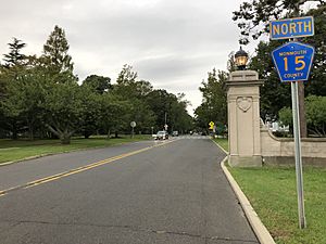
No big highways go directly through Interlaken. However, smaller roads like County Route 15 pass through. Larger state routes like Route 18 and Route 35 are easy to reach in nearby towns. The Garden State Parkway is also not far away.
Famous People from Interlaken
Some well-known people have lived in or are connected to Interlaken:
- Danny DeVito (born 1944), a famous television and film actor. He used to have a vacation home in Interlaken.
- Fred J. Cook (1911–2003), an investigative journalist and author.
- Jack Ford, a television news personality who often talks about legal topics.
- Rhea Perlman (born 1948), an actress famous for playing Carla Tortelli in the TV show Cheers.
See also
 In Spanish: Interlaken (Nueva Jersey) para niños
 | Leon Lynch |
 | Milton P. Webster |
 | Ferdinand Smith |


