Loch Arbour, New Jersey facts for kids
Quick facts for kids
Loch Arbour, New Jersey
|
||
|---|---|---|
|
Village
|
||
| Incorporated Village of Loch Arbour | ||

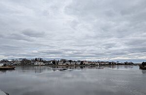
View of Loch Arbour across Deal Lake
|
||
|
||

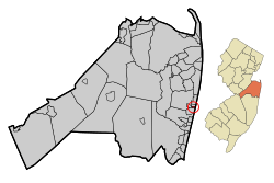
Location of Loch Arbour in Monmouth County highlighted in red (left). Inset map: Location of Monmouth County in New Jersey highlighted in orange (right).
|
||

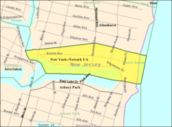
Census Bureau map of Loch Arbour, New Jersey
|
||
| Country | ||
| State | ||
| County | Monmouth | |
| Incorporated | April 23, 1957 | |
| Named for | Lochaber, Scotland | |
| Government | ||
| • Type | Walsh Act | |
| • Body | Board of Trustees | |
| Area | ||
| • Total | 0.13 sq mi (0.35 km2) | |
| • Land | 0.09 sq mi (0.22 km2) | |
| • Water | 0.05 sq mi (0.12 km2) 36.15% | |
| Area rank | 563rd of 565 in state 52nd of 53 in county |
|
| Elevation | 10 ft (3 m) | |
| Population
(2020)
|
||
| • Total | 224 | |
| • Estimate
(2023)
|
224 | |
| • Rank | 561st of 565 in state 53rd of 53 in county |
|
| • Density | 2,581.6/sq mi (996.8/km2) | |
| • Density rank | 244th of 565 in state 29th of 53 in county |
|
| Time zone | UTC−05:00 (Eastern (EST)) | |
| • Summer (DST) | UTC−04:00 (Eastern (EDT)) | |
| ZIP Code |
07711
|
|
| Area code(s) | 732 exchanges: 517, 531, 660, 663 | |
| FIPS code | 3402541010 | |
| GNIS feature ID | 0885283 | |
Loch Arbour is a small village located on the Jersey Shore. It is in Monmouth County, New Jersey. In 2020, about 224 people lived there. This was a small increase from 194 people in 2010.
Loch Arbour is one of the smallest towns in New Jersey. In 2020, it was the third smallest in land area. It was also the fifth smallest in population.
Contents
History of Loch Arbour
Loch Arbour became an official village on April 23, 1957. This happened after people voted for it. It was created from parts of Ocean Township. The village got its name from Lochaber, a place in Scotland.
Why Loch Arbour Was Formed
The village was formed because residents wanted to stop new buildings. They did not want beachfront apartments built in their area. So, they decided to separate from Ocean Township. This way, they could control their own oceanfront land.
Past Merger Attempts
Over the years, there have been talks about Loch Arbour joining other towns.
- In 1997, voters said no to merging back with Ocean Township.
- Proposals to join Allenhurst or Interlaken also failed.
In 2011 and 2012, there were more talks about merging with Allenhurst. The main reason was to lower property taxes. If they merged, students might go to Asbury Park Public Schools for less money.
Changes in Government
Loch Arbour used to have a "Village" form of government. This meant it was run by five village trustees. But on December 20, 2011, residents voted to change. They now use the Walsh Act form of government. This means the village is run by a three-member board of commissioners.
Famous Boxing Connection
In 1892, a famous boxer named James J. Corbett trained in Loch Arbour. He was getting ready for a big fight against John L. Sullivan. Corbett won that fight and became the world heavyweight boxing champion.
Geography and Location
Loch Arbour is a very small village. It covers about 0.13 square miles (0.35 square kilometers). Most of this is land, but some is water.
Where is Loch Arbour?
The village is right on the Atlantic Ocean.
- To the north is Allenhurst.
- To the west is Interlaken.
- To the south is Asbury Park.
Deal Lake
Deal Lake is a large lake that borders Loch Arbour. It covers about 158 acres. A group called the Deal Lake Commission takes care of it. Seven different towns border the lake. These include Allenhurst, Asbury Park, and Ocean Township.
Population and People
| Historical population | |||
|---|---|---|---|
| Census | Pop. | %± | |
| 1960 | 297 | — | |
| 1970 | 395 | 33.0% | |
| 1980 | 369 | −6.6% | |
| 1990 | 380 | 3.0% | |
| 2000 | 280 | −26.3% | |
| 2010 | 194 | −30.7% | |
| 2020 | 224 | 15.5% | |
| 2023 (est.) | 224 | 15.5% | |
| Population sources: 1960–1990 2000 2010 2020 |
|||
Who Lives in Loch Arbour?
In 2010, there were 194 people living in Loch Arbour. They lived in 82 households. Most people (about 95%) were White. A small number were Black or Asian. About 4% of the population was Hispanic or Latino.
The average household had about 2.37 people. The average family had about 2.91 people.
- About 19.6% of the people were under 18 years old.
- About 15.5% were 65 years or older.
- The average age in the village was 49 years old.
The average income for a household in 2010 was $120,000.
Education in Loch Arbour
Loch Arbour students attend public schools in other towns. This is because the village is very small.
Leaving Ocean Township School District
For many years, Loch Arbour was part of the Ocean Township School District. This district served students from kindergarten to twelfth grade. However, Loch Arbour paid a very high amount per student. In 2016-2017, it was about $143,000 per student. Ocean Township residents paid much less.
So, in 2017, Loch Arbour voters approved a change. They left the Ocean Township district. Now, they send their students to different schools.
Elementary and Middle School
Students in pre-kindergarten through eighth grade go to West Long Branch Public Schools. This district has two schools:
- Betty McElmon Elementary School (pre-K to 4th grade)
- Frank Antonides School (5th to 8th grade)
Students from Allenhurst and Interlaken also attend these schools.
High School
For high school, students attend Shore Regional High School. This school is in West Long Branch. It serves students from ninth to twelfth grade. Students from Monmouth Beach, Oceanport, and Sea Bright also go to this high school.
Transportation
Loch Arbour has about 2.04 miles of roads. Most of these are maintained by the village itself.
Main Roads
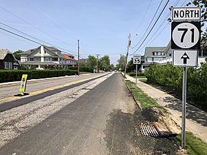
Route 71 is the main road that goes north and south through the village.
Travel Times
Loch Arbour is about one hour south of New York City. It is also east of Philadelphia. The closest major highway is Route 18. Other major roads like Interstate 195 and the Garden State Parkway are about 15 minutes away.
Public Transport
NJ Transit offers bus service in the village on the 837 (New Jersey bus) route. Train service is also available nearby. The Allenhurst station is in the next town, Allenhurst. The North Jersey Coast Line train passes through Loch Arbour but does not stop there.
Climate and Weather
Loch Arbour has a humid subtropical climate. This means it has warm, humid summers and mild winters.
Summer Weather
Most summer days are a bit humid. A cool sea breeze often blows in the afternoon. Sometimes, it can get very hot and humid. The highest temperature ever recorded was about 100 degrees Fahrenheit (38 degrees Celsius) in August 2001. July is usually when the most thunderstorms happen. August is often the wettest month.
Winter Weather
In winter, the average coldest temperature is around 3.7 degrees Fahrenheit (-15.7 degrees Celsius). The coldest temperature ever recorded was -6 degrees Fahrenheit (-21 degrees Celsius) in January 1984. Sometimes, it can feel even colder due to strong winds. On average, Loch Arbour gets about 18 to 24 inches (46 to 61 cm) of snow each winter. February is usually the snowiest month.
| Climate data for Loch Arbour, 1981–2010 normals, extremes 1981–2019 | |||||||||||||
|---|---|---|---|---|---|---|---|---|---|---|---|---|---|
| Month | Jan | Feb | Mar | Apr | May | Jun | Jul | Aug | Sep | Oct | Nov | Dec | Year |
| Record high °F (°C) | 71.4 (21.9) |
78.9 (26.1) |
82.4 (28.0) |
88.3 (31.3) |
95.1 (35.1) |
97.0 (36.1) |
100.0 (37.8) |
100.3 (37.9) |
97.5 (36.4) |
94.0 (34.4) |
80.5 (26.9) |
75.0 (23.9) |
100.3 (37.9) |
| Mean daily maximum °F (°C) | 40.0 (4.4) |
42.6 (5.9) |
49.1 (9.5) |
58.7 (14.8) |
68.2 (20.1) |
77.4 (25.2) |
82.8 (28.2) |
81.6 (27.6) |
75.4 (24.1) |
65.0 (18.3) |
55.2 (12.9) |
45.2 (7.3) |
61.9 (16.6) |
| Daily mean °F (°C) | 32.5 (0.3) |
34.8 (1.6) |
40.9 (4.9) |
50.3 (10.2) |
59.9 (15.5) |
69.4 (20.8) |
74.9 (23.8) |
73.9 (23.3) |
67.4 (19.7) |
56.4 (13.6) |
47.3 (8.5) |
37.7 (3.2) |
53.9 (12.2) |
| Mean daily minimum °F (°C) | 24.9 (−3.9) |
26.9 (−2.8) |
32.7 (0.4) |
41.9 (5.5) |
51.6 (10.9) |
61.3 (16.3) |
67.1 (19.5) |
66.1 (18.9) |
59.3 (15.2) |
47.8 (8.8) |
39.4 (4.1) |
30.2 (−1.0) |
45.9 (7.7) |
| Record low °F (°C) | −6.0 (−21.1) |
0.9 (−17.3) |
5.7 (−14.6) |
18.3 (−7.6) |
34.9 (1.6) |
44.6 (7.0) |
48.3 (9.1) |
45.4 (7.4) |
39.0 (3.9) |
26.2 (−3.2) |
14.9 (−9.5) |
−0.4 (−18.0) |
−6.0 (−21.1) |
| Average precipitation inches (mm) | 3.62 (92) |
3.07 (78) |
3.91 (99) |
4.16 (106) |
3.85 (98) |
3.59 (91) |
4.69 (119) |
4.76 (121) |
3.64 (92) |
3.96 (101) |
3.84 (98) |
4.02 (102) |
47.11 (1,197) |
| Average relative humidity (%) | 64.6 | 61.5 | 60.5 | 61.8 | 66.0 | 70.0 | 69.9 | 71.2 | 71.3 | 69.4 | 67.3 | 65.0 | 66.6 |
| Average dew point °F (°C) | 21.9 (−5.6) |
22.9 (−5.1) |
28.3 (−2.1) |
37.7 (3.2) |
48.5 (9.2) |
59.2 (15.1) |
64.4 (18.0) |
64.0 (17.8) |
57.8 (14.3) |
46.5 (8.1) |
37.0 (2.8) |
27.0 (−2.8) |
43.0 (6.1) |
| Source: PRISM | |||||||||||||
| Climate data for Sandy Hook, NJ Ocean Water Temperature (16 N Loch Arbour) | |||||||||||||
|---|---|---|---|---|---|---|---|---|---|---|---|---|---|
| Month | Jan | Feb | Mar | Apr | May | Jun | Jul | Aug | Sep | Oct | Nov | Dec | Year |
| Daily mean °F (°C) | 37 (3) |
36 (2) |
40 (4) |
46 (8) |
55 (13) |
62 (17) |
69 (21) |
72 (22) |
68 (20) |
59 (15) |
51 (11) |
43 (6) |
53 (12) |
| Source: NOAA | |||||||||||||
Ecology and Nature
Loch Arbour's natural plant life would mostly be Oak trees. It is part of the Eastern Hardwood Forest area. The climate zone is 7a. This means the average coldest temperature in winter is around 3.7 degrees Fahrenheit (-15.7 degrees Celsius). New leaves usually appear around March 24. Fall colors are brightest in early November.
Notable People
People who have lived in or are connected to Loch Arbour include:
- Peter Dobson (born 1964), an actor who was in the movie Forrest Gump.
- Radia Perlman (born 1951), an inventor known for creating the Spanning Tree Protocol, which helps computers talk to each other.
See also
 In Spanish: Loch Arbour para niños
 | Toni Morrison |
 | Barack Obama |
 | Martin Luther King Jr. |
 | Ralph Bunche |


