Allenhurst, New Jersey facts for kids
Quick facts for kids
Allenhurst, New Jersey
|
||
|---|---|---|
|
Borough
|
||
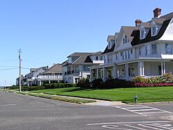
The Allenhurst Residential Historic District, at the Jersey Shore
|
||
|
||
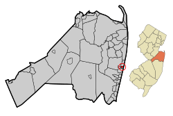
Location of Allenhurst in Monmouth County circled and highlighted in red (left). Inset map: Location of Monmouth County in New Jersey highlighted in orange (right).
|
||
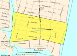
Census Bureau map of Allenhurst, New Jersey
|
||
| Country | ||
| State | ||
| County | Monmouth | |
| Incorporated | April 26, 1897 | |
| Named for | Abner Allen | |
| Government | ||
| • Type | Walsh Act | |
| • Body | Board of Commissioners | |
| Area | ||
| • Total | 0.28 sq mi (0.73 km2) | |
| • Land | 0.25 sq mi (0.65 km2) | |
| • Water | 0.03 sq mi (0.08 km2) 11.43% | |
| Area rank | 554th of 565 in state 50th of 53 in county |
|
| Elevation | 23 ft (7 m) | |
| Population
(2020)
|
||
| • Total | 472 | |
| • Estimate
(2023)
|
466 | |
| • Rank | 553rd of 565 in state 52nd of 53 in county |
|
| • Density | 1,884.4/sq mi (727.6/km2) | |
| • Density rank | 303rd of 565 in state 38th of 53 in county |
|
| Time zone | UTC−05:00 (Eastern (EST)) | |
| • Summer (DST) | UTC−04:00 (Eastern (EDT)) | |
| ZIP Codes |
07711
|
|
| Area codes | 732 exchanges: 517, 531, 660, 663 | |
| FIPS code | 3402500730 | |
| GNIS feature ID | 0885136 | |
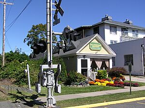
Allenhurst is a small town, called a borough, right on the Jersey Shore in Monmouth County, New Jersey. It was named after a person named Abner Allen. It officially became a borough on April 26, 1897. Before that, it was part of Ocean Township.
In 2020, about 472 people lived there. The number of people living in Allenhurst has gone down a bit over the years. Allenhurst is special because it has the Atlantic Ocean on one side and Deal Lake on the other. It's also close to New York City and has a train station (the North Jersey Coast Line) that can take you there.
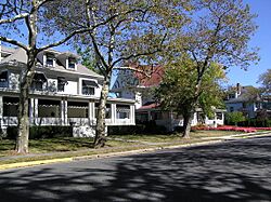
Allenhurst is in the middle of several wealthy communities. Many old, beautiful homes built in the late 1800s and early 1900s are found here. In 2006, Forbes magazine said Allenhurst had one of the most expensive ZIP Codes in the United States.
Contents
History of Allenhurst
Allenhurst started as a rural area and grew into a popular resort town. In 1895, a company bought a 120-acre farm. They wanted to build a special community for wealthy summer visitors. Being close to the train line helped Allenhurst become very popular. It made it easy for people from New York City to visit.
On April 26, 1897, Allenhurst officially became a borough. This happened through a law passed by the New Jersey Legislature. The borough was named after Abner Allen, who lived there.
Historic Homes and Architecture
Many historic homes were built in Allenhurst during the late 1800s and early 1900s. These homes show off many different styles of architecture. Some styles include Victorian, Queen Anne, and Colonial Revival.
Local rules help protect these old buildings. There's a special group that makes sure any changes to older homes follow strict guidelines. This helps keep the town's historic look.
In 2006, Allenhurst was ranked 131st on Forbes magazine's list of most expensive ZIP Codes. By 2012, it was ranked 448th, with homes costing around $665,043 on average.
After Hurricane Sandy
In October 2012, Hurricane Sandy caused a lot of damage to the shoreline. In 2015, the U.S. Army Corps of Engineers (USACE) added sand to the beaches. This sand, however, contained old military items. These were parts of World War I artillery.
From December 2016 to March 2017, specialists removed 362 small, potentially live pieces. These were mostly boosters, which are small parts that help artillery shells explode. They were likely left over from World War I. This isn't uncommon in areas like Gateway's Sandy Hook Unit. That area was a military base until 1974. It was also a testing ground for the U.S. Army from 1874 to 1919.
Allenhurst Residential Historic District
The Allenhurst Residential Historic District is a special area in Allenhurst. It includes many historic buildings. This district was added to the National Register of Historic Places on June 18, 2010. It's recognized for its important architecture. There are 412 buildings in this district that contribute to its historic value.
Geography and Location
Allenhurst is a small borough, covering about 0.28 square miles (0.73 square kilometers). Most of this area is land, with a small part being water.
The borough is next to the Atlantic Ocean on its east side. To the west, it borders Deal Lake. It's also quite close to New York City. Allenhurst shares borders with other towns in Monmouth County, like Deal, Interlaken, Loch Arbour, and Ocean Township.
The beach area has two special structures called groins. Locals call them "Crackup" and "The L." "The L" is even famous among scuba divers as a great spot to dive in New Jersey.
Deal Lake is a large lake, covering about 158 acres. Seven towns border the lake, making up about 27 miles of shoreline. These towns include Asbury Park, Deal, Interlaken, Loch Arbour, Neptune Township, and Ocean Township.
Population and People
| Historical population | |||
|---|---|---|---|
| Census | Pop. | %± | |
| 1900 | 165 | — | |
| 1910 | 306 | 85.5% | |
| 1920 | 343 | 12.1% | |
| 1930 | 573 | 67.1% | |
| 1940 | 520 | −9.2% | |
| 1950 | 758 | 45.8% | |
| 1960 | 795 | 4.9% | |
| 1970 | 1,012 | 27.3% | |
| 1980 | 912 | −9.9% | |
| 1990 | 759 | −16.8% | |
| 2000 | 718 | −5.4% | |
| 2010 | 496 | −30.9% | |
| 2020 | 472 | −4.8% | |
| 2023 (est.) | 466 | −6.0% | |
| Population sources: 1900–1920 1900–1910 1910–1930 1940–2000 2000 2010 2020 |
|||
In 2010, there were 496 people living in Allenhurst. Most of the people were White (94.76%). There were also smaller groups of Black or African American, Asian, and people of two or more races. About 4.44% of the population was Hispanic or Latino.
The average age of people in Allenhurst was 47.2 years old. About 15.3% of the population was under 18. About 19.8% were 65 years or older.
Fun and Recreation
The Allenhurst Beach Club is a popular place for fun. It has 2,450 members and attracts many people during the summer. As of 2013, it had a huge saltwater swimming pool and a children's wading pool. It also has cabanas and bathhouses. The borough now says that new memberships are only for people who live in Allenhurst.
Schools and Education
Allenhurst does not have its own public schools. For many years, students from Allenhurst went to schools in Asbury Park. But in 2017, this changed.
Now, younger students (from pre-kindergarten to eighth grade) go to the West Long Branch Public Schools. This district has two schools:
- Betty McElmon Elementary School (pre-kindergarten to fourth grade)
- Frank Antonides School (fifth to eighth grade)
For high school (ninth through twelfth grades), students attend Shore Regional High School. This high school is in West Long Branch. Students from Monmouth Beach, Oceanport, and Sea Bright also go to this school.
Some students also have another choice. They can attend Academy Charter High School in Lake Como. This school accepts students through a lottery system. It is open to students from Allenhurst and several nearby towns.
Getting Around Allenhurst
As of 2010, Allenhurst had about 5.14 miles of roads. Most of these roads are maintained by the borough itself.
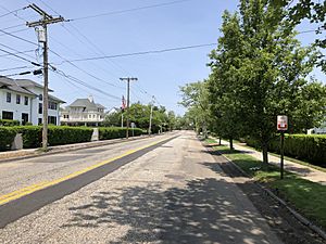
The main highway in Allenhurst is New Jersey Route 71.
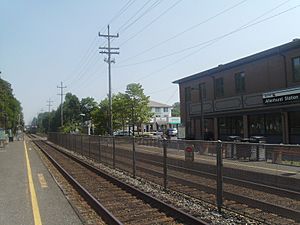
For public transportation, you can use NJ Transit trains. The Allenhurst station is on the North Jersey Coast Line. This train line can take you to places like Newark Penn Station and New York Penn Station. The train station building itself is historic and has been on the National Register of Historic Places since 1980.
New Jersey Transit also offers local bus service on the 837 route.
Climate
Allenhurst has a Humid subtropical climate (Cfa). This means it has hot, humid summers and mild winters.
See also
 In Spanish: Allenhurst (Nueva Jersey) para niños
Notable People
Many interesting people have lived in or are connected to Allenhurst:
- Bob Considine (1906–1975), a famous author and newspaper writer.
- Dorothy Fields (1905–1974), a talented writer of songs and plays, was born in Allenhurst.
- Alice Joyce (1890–1955), a well-known film actress, had a summer home here.
- Al Meyers (1908–1976), a pioneer in aviation who started the Meyers Aircraft Company.
- Gloria Monty (1921–2006), a television producer famous for her work on General Hospital.
 | Jackie Robinson |
 | Jack Johnson |
 | Althea Gibson |
 | Arthur Ashe |
 | Muhammad Ali |


