Lake Como, New Jersey facts for kids
Quick facts for kids
Lake Como, New Jersey
|
|||
|---|---|---|---|
|
Borough
|
|||

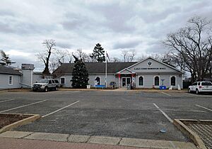
Lake Como Borough Hall
|
|||
|
|||

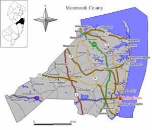
Map of Lake Como in Monmouth County. Inset: Location of Monmouth County highlighted in the State of New Jersey.
|
|||

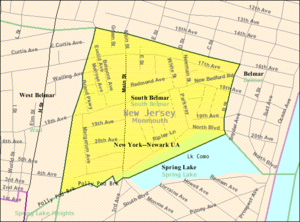
Census Bureau map of Lake Como, New Jersey
|
|||
| Country | |||
| State | |||
| County | Monmouth | ||
| Incorporated | May 6, 1924 as South Belmar | ||
| Renamed | January 4, 2005 as Lake Como | ||
| Government | |||
| • Type | Borough | ||
| • Body | Borough Council | ||
| Area | |||
| • Total | 0.26 sq mi (0.67 km2) | ||
| • Land | 0.25 sq mi (0.65 km2) | ||
| • Water | 0.01 sq mi (0.02 km2) 3.08% | ||
| Area rank | 556th of 565 in state 51st of 53 in county |
||
| Elevation | 16 ft (5 m) | ||
| Population
(2020)
|
|||
| • Total | 1,697 | ||
| • Estimate
(2023)
|
1,665 | ||
| • Rank | 501st of 565 in state 45th of 53 in county |
||
| • Density | 6,741.7/sq mi (2,603.0/km2) | ||
| • Density rank | 73rd of 565 in state 6th of 53 in county |
||
| Time zone | UTC−05:00 (Eastern (EST)) | ||
| • Summer (DST) | UTC−04:00 (Eastern (EDT)) | ||
| ZIP Code |
07719 – Belmar
|
||
| Area code(s) | 732 | ||
| FIPS code | 3402537560 | ||
| GNIS feature ID | 0885400 | ||
| Website | |||
Lake Como is a small town, called a borough, located in the Jersey Shore area of New Jersey. It's part of Monmouth County. In 2020, about 1,697 people lived there.
This town was first created on March 12, 1924. Back then, it was called South Belmar. It was formed from parts of Wall Township. On January 4, 2005, the town officially changed its name to Lake Como.
Contents
About Lake Como's Location
Lake Como is a very small place. It covers about 0.26 square miles (0.67 square kilometers). Most of this area is land, with a small part being water.
The borough shares its borders with several other towns in Monmouth County. These include Belmar, Spring Lake, Spring Lake Heights, and Wall Township.
How Many People Live in Lake Como?
| Historical population | |||
|---|---|---|---|
| Census | Pop. | %± | |
| 1930 | 886 | — | |
| 1940 | 955 | 7.8% | |
| 1950 | 1,294 | 35.5% | |
| 1960 | 1,537 | 18.8% | |
| 1970 | 1,490 | −3.1% | |
| 1980 | 1,566 | 5.1% | |
| 1990 | 1,482 | −5.4% | |
| 2000 | 1,806 | 21.9% | |
| 2010 | 1,759 | −2.6% | |
| 2020 | 1,697 | −3.5% | |
| 2023 (est.) | 1,665 | −5.3% | |
| Population sources: 1930 1940–2000 2000 2010 2020 |
|||
Population in 2010
In 2010, there were 1,759 people living in Lake Como. They lived in 785 households. The town had a population density of about 6,943 people per square mile.
Most of the people living in Lake Como were White (82.89%). There were also Black or African American (6.14%), Native American (0.85%), and Asian (1.19%) residents. About 18.31% of the population was Hispanic or Latino.
The average age of people in Lake Como in 2010 was 38.4 years old.
Schools in Lake Como
Students in Lake Como attend public schools through a special arrangement.
Elementary and Middle School
For students in pre-kindergarten through eighth grade, the Belmar School District serves them. These students go to Belmar Elementary School. Lake Como is a "non-operating district," meaning it doesn't have its own school building for these grades. Instead, its students attend school in nearby Belmar.
High School Options
After eighth grade, students from Lake Como go to public high school in one of two places. They are assigned to either Manasquan High School in Manasquan or Asbury Park High School in Asbury Park. About 56% of students go to Manasquan High School, and 44% go to Asbury Park High School.
Manasquan High School also welcomes students from other nearby towns. These include Avon-by-the-Sea, Brielle, Sea Girt, Spring Lake, and Spring Lake Heights.
Other School Choices
Students also have other options for high school. They can attend specialized schools like Red Bank Regional High School or High Technology High School. There's also Academy Charter High School located right in Lake Como. This charter school accepts students through a lottery system from several local communities.
Getting Around Lake Como
Roads and Highways
Lake Como has about 5.47 miles of roads. Most of these are maintained by the town itself. No major highways pass directly through Lake Como. However, important roads like Route 35 and the Garden State Parkway are easily reached in nearby towns.
Public Transportation
NJ Transit provides bus services for Lake Como residents. The 317 bus route connects to Philadelphia. There is also a local bus service, the 830 route, for travel within the area.
Famous People from Lake Como
- Walter McAfee (1914–1995): He was an important African-American scientist and astronomer. He helped with the world's first experiments to bounce radar signals off the Moon. This was part of something called Project Diana.
See also
 In Spanish: Lake Como (Nueva Jersey) para niños
 | Georgia Louise Harris Brown |
 | Julian Abele |
 | Norma Merrick Sklarek |
 | William Sidney Pittman |


