
Gateway National Recreation Area facts for kids
Quick facts for kids Gateway National Recreation Area |
|
|---|---|
|
IUCN Category V (Protected Landscape/Seascape)
|
|
 |
|
| Location | New York and New Jersey, United States |
| Area | 26,607 acres (107.67 km2) |
| Established | October 27, 1972 |
| Visitors | 8,404,728 (in 2020) |
| Governing body | National Park Service |
| Website | Gateway National Recreation Area |
Gateway National Recreation Area is a huge park area that covers about 26,607 acres (10,767 hectares). It is located in New York City and Monmouth County, New Jersey. This special place offers many fun activities you might not expect to find in a big city.
You can go ocean swimming, watch birds, go boating, hike, and even camp here. About 10 million people visit Gateway every year!
The United States Congress (the group that makes laws for the country) created Gateway in 1972. They wanted to protect special natural areas and offer places for people to have fun. It's owned by the government and managed by the National Park Service, which takes care of national parks.
Contents
How Gateway Was Created
In 1969, a group called the Regional Plan Association suggested creating a new national seashore near New York City. This would be managed by the United States Department of the Interior, a government department that manages public lands.
In 1970, U.S. President Richard Nixon supported a similar idea. He wanted it to be a "national park" instead of a "seashore." He started the process to get Congress to approve this plan.
In September 1972, the United States House of Representatives approved the creation of Gateway National Recreation Area. Most of the land was then given to the National Park Service (NPS). This made it part of the new Gateway area.
Gateway National Recreation Area officially opened on October 27, 1972. Another similar park, Golden Gate National Recreation Area in San Francisco, was also created at the same time. Gateway included over 26,000 acres (10,522 hectares) of land.
Park Areas and Sites
Gateway National Recreation Area has three main sections and 11 different park sites. The United States Park Police helps keep people safe in the New York areas. National Park Service Rangers do the same in the New Jersey section.
Jamaica Bay Unit
The Jamaica Bay Unit is in Brooklyn and Queens, New York. It includes much of the shoreline and water around Jamaica Bay. This bay is a tidal estuary, meaning fresh river water mixes with salty ocean water here. This unit also covers most of the western part of the Rockaway Peninsula. This peninsula separates Jamaica Bay from the Atlantic Ocean.
Here are some of the cool places in this unit:
- Jamaica Bay Wildlife Refuge is a fantastic spot for watching birds. You can see many different kinds of birds, especially during their migrations. You might also spot diamondback turtles laying eggs or horseshoe crabs mating. This refuge is 9,155 acres (3,705 hectares) and has open water, salt marshes, sand dunes, and woodlands. It's the only "wildlife refuge" managed by the National Park System.
- Shirley Chisholm State Park was built on top of an old landfill (a place where trash was buried). This park shows how old dump sites can be turned into useful parks. It has bike paths, free bike rentals, kayaking, fishing, and walking trails. The first part of the park opened in 2019.
- Floyd Bennett Field is an old airport that isn't used for planes anymore. It has a special area with old buildings that are important to history. You can visit Hangar B to see volunteers working to fix up old airplanes. The Ryan Visitor Center, which used to be the control tower, has exhibits about the airport's history.
- Floyd Bennett Field is also the only public campground in New York City. It has 46 campsites with hot showers and clean bathrooms. It's a great place to see falcons and kestrels. You can also find sports areas and ice skating rinks in some of the old airplane hangars.
- Canarsie Pier is a popular spot for picnics and fishing on the north side of Jamaica Bay.
- Fort Tilden is on the Rockaway peninsula. It has some of the quietest ocean beaches in the city. You can find a forest that is growing back naturally, sand dunes, and a freshwater pond. This area was once part of the harbor's defenses. Today, you can climb an old battery for amazing views of Jamaica Bay and the Manhattan skyline. It's also a great place to watch hawks during their fall migration.
- Breezy Point Tip is at the very western end of the Rockaway peninsula. It has ocean beaches, bay shoreline, dunes, and marshes. This area is a nesting spot for the threatened piping plover, a small bird.
- Jacob Riis Park is an ocean beach with a boardwalk and a historic bathhouse. The bathhouse has cool Art Deco designs. This park was named after Jacob Riis, a famous journalist and reformer.


Staten Island Unit
The Staten Island Unit is on the southeastern shore of Staten Island. It faces Lower New York Bay. This unit includes Hoffman and Swinburne Islands, which are closed to visitors to protect birds.
This unit also has these three sites:
- Fort Wadsworth is a historic collection of old stone forts. It sits at the Narrows of New York Bay, a narrow waterway.
- Miller Field is an old airport with picnic areas, open fields, and sports fields.
- Great Kills Park has a marina where you can go boating. It also has a beach with lifeguards in the summer and nature trails. This park is a nesting site for osprey, a type of fish-eating hawk.
Sandy Hook Unit
The Sandy Hook Unit is in Monmouth County, New Jersey. This barrier peninsula (a long, narrow piece of land that protects the coast) forms the other side of the "gateway" to New York Harbor.
It includes two park sites:
- Fort Hancock was part of the harbor's coastal defense system from 1895 to 1974. It has 100 historic buildings and old forts.
- Sandy Hook has seven beaches, as well as salt marshes and a maritime holly forest (a forest near the ocean with holly trees). You can take ferries from Manhattan to get here during certain times of the year. Fishing and using small boats are popular activities here.
Images for kids
-
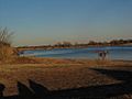
Typical views along Jamaica Bay
-
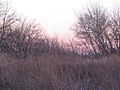
Typical plants found on Jamaica Bay shores
-
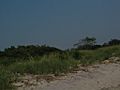
Typical plants found at the coastal edge of Gateway
-
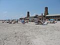
The beach at Jacob Riis Park


See also
