
Geography of New York–New Jersey Harbor Estuary facts for kids
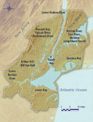
The New York–New Jersey Harbor Estuary, also known as the Hudson-Raritan Estuary, is a huge system of waterways. It is located on the East Coast of the United States in New Jersey and New York. This area forms one of the most complex natural harbors in the world. It connects to the Atlantic Ocean through the New York Bight and to Long Island Sound.

.jpg)
Even though the estuary looks similar to how it did in 1524 when Giovanni da Verrazzano first explored it, many parts have changed. For example, areas like Hell Gate and Ellis Island look very different now. One of the biggest changes is that the shipping channels have been made much deeper. They were naturally about 17 feet deep, but now they are 45 feet deep. In some places, this even required blasting through solid rock!
The estuary has a very complex system of tides and currents. Both the New York Bight and Long Island Sound are mostly saltwater bodies with tides. However, Long Island Sound is less salty than the Atlantic Ocean. Its tides also arrive about 3 hours later and can be much larger. Rivers add fresh, non-tidal water to the system. But the tides and salty water can reach far up the rivers, all the way from Albany to Montauk Point. The New York Harbor Observing and Prediction System (NYHOPS) uses sensors and weather forecasts to predict conditions in the harbor in real-time.
Since a big storm in 1962, beaches along the East Coast have been regularly refilled with sand. This sand is pumped in from offshore. The United States Army Corps of Engineers (USACE) helps manage these projects. In 2016, the USACE and the Port Authority of New York and New Jersey created a plan to restore the harbor. This plan included ideas to reduce the effects of sea level rise by bringing back natural areas.
Contents
Features of the Harbor Estuary
This section lists important parts of the Port of New York and New Jersey. It focuses on natural water features. The list generally goes clockwise around the harbor, starting from the Lower Bay entrance.

2. Lower New York Bay
3. Newark Bay
4. Hudson River
5. East River
6. Raritan Bay
7. Jamaica Bay
8. Long Island Sound
9. New York Bight-North Atlantic
10. Ambrose Channel
11. Mud Dump Site
12. Hudson Canyon
A. Manhattan
B. Brooklyn
C. Staten Island
D. Queens
E. The Bronx
F. Bayonne-Jersey City
G. Newark
H. Raritan Bayshore
i. Rockaway Point
j. Sandy Hook
(This map is not for navigation.)

Official maps and charts from the NOAA and the USGS are used as references for these features.
Rivers and Streams
Many rivers and streams flow into the New York–New Jersey Harbor Estuary. Some are shared between New Jersey and New York, while others are entirely within one state.
Shared between New Jersey and New York
- Hudson River
- The lowest part is also called the North River.
New Jersey
New York
- Bronx River
- Coney Island Creek
- Flushing River
- Fresh Kills
- Gowanus Canal (used to be Gowanus Creek)
- Hutchinson River
- Newtown Creek
- Tibbetts Brook
Tidal Straits
Tidal straits are narrow waterways that connect larger bodies of water and are affected by tides.
Shared between New Jersey and New York
New York
Bays, Inlets, and Coves
The estuary includes many different bays, inlets, and coves, which are smaller water bodies connected to the main harbor.
- Upper New York Bay
- Gowanus Bay
- Newark Bay
- Weehawken Cove
Long Island Sound
Islands
Many islands are found within the harbor estuary. Some are shared by both states, while others belong to New Jersey or New York.
- Ellis Island—Most of the land added to Ellis Island is in Jersey City, New Jersey. The original part of the island is in New York State.
- Liberty Island—This island, home to the Statue of Liberty, is part of New York but is surrounded by waters of Jersey City.
- Shooters Island—Located at the top of Kill Van Kull, it is partly in New Jersey and partly in New York.
New Jersey
- Plum Island, Sandy Hook Bay
- Robbins Reef
New York
|
Bronx County |
Kings County (Brooklyn)
New York County (Manhattan)
|
Queens County
Richmond County (Staten Island) |
Land Features
These are important land areas that shape the harbor and its shores.
New Jersey
New York
- Coney Island (used to be a separate island)
- Red Hook
- Rockaway Point
- Throgs Neck
Banks and Shoals
Banks and shoals are shallow areas in the water. They can be important for navigation or for marine life.
Lower Bay
- East Bank
- Flynns Knoll
- Old Orchard Shoal
- Romer Shoal
- West Bank
Upper Bay
- Bay Ridge Flats
- Gowanus Flats
- Jersey Flats
East River
- College Point Reef
- Mill Rock
- Rhinelander Reef
Navigational channels are deeper paths in the water that ships use to travel safely through the harbor.
Lower Bay
- Ambrose Channel
- Coney Island Channel
- Sandy Hook Channel
Raritan Bay
- Raritan River Cutoff
Jamaica Bay
- Beach Channel
Arthur Kill
- Elizabeth Port Reach
- Port Reading Reach
Newark Bay
- Elizabeth Channel
- Newark Bay Middle Reach
- Port Newark Branch Channel
Kill van Kull
- Constable Hook Reach
Upper Bay
- Anchorage Channel
- Bayridge Channel
- Buttermilk Channel
- Red Hook Channel
Hudson River
- Weehawken Edgewater Channel
East River
- East Channel
- West Channel
Port Facilities
The Port Authority of New York and New Jersey helps manage trade and shipping in the area. They run many of the large container terminals. They also work with the Army Corps of Engineers to keep the shipping channels deep enough.
New Jersey
- Port Jersey
- Port Newark–Elizabeth Marine Terminal, in Newark and Elizabeth (operated by the Port Authority)
New York
- Brooklyn
- Red Hook Container Terminal (operated by the Port Authority)
- Staten Island
- Howland Hook Marine Terminal (operated by the Port Authority)
Lights and Lighthouses
Lighthouses and other lights guide ships safely through the harbor, especially at night.
New Jersey
New York
- Ambrose Light
- Coney Island Light
- Execution Rocks Light
- Jeffreys Hook Light
- Staten Island Range Light
- Stepping Stones Light
- Throgs Neck Light
Waterfront Jurisdictions
Many different groups and levels of government manage the waterfront areas of the harbor.
Government and Other Agencies
- National Park Service
- Port Authority of New York and New Jersey
- United States Army Corps of Engineers
- United States Coast Guard
- Waterfront Commission of New York Harbor
State, County, Municipal
- Monmouth County
- Atlantic Highlands
- Keyport
- Middlesex County
- Perth Amboy
- Carteret
- Union County
- Essex County
- Hudson County
- New York City
- Manhattan
- Brooklyn
- Coney Island
- Bay Ridge
- Red Hook
- Queens
- Far Rockaway
- Flushing
- The Bronx
- City Island
- Staten Island
- Port Richmond
- St. George
- Tottenville
Images for kids
-
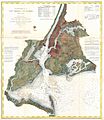
1866 map of the harbor estuary

