
Rahway River facts for kids


The Rahway River is a river in New Jersey, United States. It flows through Essex, Middlesex, and Union Counties. The river ends at the Arthur Kill, which is a waterway between New Jersey and Staten Island, New York.
The Rahway River is about 24 miles (39 km) long. It drains parts of New Jersey that are west of Staten Island. The upper parts of the river have many parks, while the end of the river is used for industrial shipping.
Long ago, the Lenape Native Americans lived on the lands around the river. People say the river was named after Rahwack, a local tribal chief.
The City of Rahway gets its drinking water from this river. Also, every spring, about 6,000 trout fish are added to the river for fishing. The river also gave its name to the Rahway Valley Railroad, which has a bridge over it.
Contents
Where Does the Rahway River Flow?

The Rahway River starts in Essex County with two main parts.
West and East Branches
The West Branch begins at Crystal Lake in West Orange. It flows south through the South Mountain Reservation. This part of the river goes right through downtown Millburn.
The East Branch also starts in West Orange. It forms part of the border between West Orange and Orange. Then it flows through South Orange and Maplewood.
These two branches meet near Interstate 78. From there, the river flows south through towns like Springfield, Union, Cranford, and Clark.
Meeting Other Streams
In Rahway, the river gets water from two more streams: the Robinson's Branch and the South Branch. These are about 10 miles (16 km) long. The South Branch starts in Roosevelt Park in Edison and flows through Edison, Iselin, and Rahway.
The Rahway River finally reaches the Arthur Kill. This is between Carteret to the south and Linden to the north.
Smaller Streams Joining the River
Several smaller streams, called tributaries, also join the Rahway River:
- Nomahegan Brook flows through Cranford, Kenilworth, Westfield, and Mountainside.
- Gallows Hill Brook starts in Fairview Cemetery in Westfield and joins the Rahway River at Hampton Park.
- Orchard Brook flows through Garwood and joins the Rahway in Cranford.
- Kings Creek, Cross Creek, and Marshes Creek join the Rahway closer to the Arthur Kill.
Parks Along the Rahway River
The Rahway River flows through many beautiful parks.
South Mountain Reservation


South Mountain Reservation is a large park with Orange Reservoir and Campbell's Pond. A cool spot is Hemlock Falls, a 25-foot (7.6 m) waterfall where the Rahway River cascades over rocks. The Orange Reservoir used to be a source of drinking water. Now, it's becoming a place for fun activities like miniature golf and boating.
Just below this reservation, in Millburn, New Jersey, the river flows through Taylor Park.
Rahway River Parkway
The Rahway River Parkway is a long stretch of parkland that follows the Rahway River. It was created in the 1920s and designed by the Olmsted Brothers, famous landscape architects.
A group called "Friends of Rahway River Parkway" works to keep the parkway beautiful. They want to protect it and help people enjoy it.
Some parks along the Rahway River Parkway include:
- Briant Park in Springfield.
- Echo Lake Park in Westfield/Mountainside, which has a lake formed by Nomahegan Brook.
- In Cranford, New Jersey, the parkway follows the river through Lenape Park, Nomahegan Park, Hampton Park, and many other parks. The Cranford Canoe Club is also here.
- Rahway River Park in Rahway, New Jersey is next to a graveyard. Milton Lake Park is a popular spot for fishing.
Lower River Parks
- Hawk Rise Sanctuary in Linden, New Jersey is a 95-acre (38 ha) nature preserve with wetlands.
- Joseph Medwick Memorial Park in Carteret is named after a baseball player. It has great river views, sports fields, and picnic areas.
The lower parts of the Rahway River have large areas of salt marshes and mudflats. These are important homes for many birds like gulls, shorebirds, egrets, ducks, and hawks. Over 1,500 gulls and many other bird species use this area.
Fun Things to Do on the Rahway River
The Rahway River offers many ways to enjoy nature and have fun!
Canoeing and Boating
The Cranford Canoe Club, built in 1908, lets you rent canoes and kayaks to explore the Rahway River in Cranford. The Rahway Yacht Club, started in 1904, is a private club for boaters on the river in Rahway.
You can also go paddle boating on Echo Lake in Westfield and Orange Reservoir in South Mountain.
Fishing on the Rahway River
Fishing is a very popular activity on the Rahway River. Many local fishermen care deeply about keeping the river clean for wildlife.
It's important for fishermen to take home all their fishing line. This helps protect birds like osprey and other animals from getting tangled.
The Rahway River Trout Unlimited Chapter meets monthly to talk about fishing. You might see fly fishermen casting their lines near the dams in Cranford.
Different types of trout are added to the river from late March to mid-May, including Brown trout, brook trout, and rainbow trout. Some of these are quite large, weighing up to 5 pounds!
You can also find many sunfish and catfish in the Rahway River. Smallmouth bass and largemouth bass are present, some of them very big. Channel catfish and bullhead catfish are also common.
Sometimes, Striped bass and eels swim up the river from Raritan Bay. You might even catch large and strong carp.
Helping Fish Move Upstream
The Rahway River is home to several types of fish that travel between fresh and saltwater. Some fish, like alewife and blueback herring, spawn (lay eggs) in freshwater but live in saltwater. Others, like the American eel, spawn in the ocean but live in freshwater.
There are plans to build a fish ladder at the Rahway City Water Works. A fish ladder is like a set of small steps underwater that helps fish swim around dams. This would allow these fish to move further up the river to lay their eggs. Removing old obstacles and cleaning the water also helps fish travel.
Birdwatching
Many people enjoy Birdwatching along the Rahway River. Groups like the Friends of Lenape Park often go birdwatching by the river's streams.
Other Fun Activities
- The Riverside Inn and the River and Rail Cantina in Cranford have outdoor seating by the river.
- McLoone's Boathouse is located on Orange Reservoir.
- The famous Paper Mill Playhouse theater is also next to the river.
The Hanson Park Conservancy holds an annual "rubber ducky race" in the river. This fun event helps raise money for the park.
On the day after Halloween, the Great Pumpkin Sail takes place at Echo Lake. Families bring their lit Jack-O-Lanterns and set them afloat on the lake. It's a glowing sight, and families enjoy hot chocolate and marshmallows by a campfire.
History of the Rahway River
The Rahway River has a rich history with many interesting uses over the years.
Water Carnivals
Starting in the 1880s, groups in Cranford held exciting water carnivals and boat races on the river. An old newspaper article from 1886 described how nearly a hundred boats were decorated with sky lanterns. The river banks and bridges were lit up with colored lights, and there were bands and fireworks!
Mills and Factories
The Rahway River was once home to many sawmills (for cutting wood) and gristmills (for grinding grain). Droeschers Mill is the last mill still standing on the Rahway River.
The Paper Mill Playhouse is a well-known theater today. It was originally a paper mill built in 1795 by Sam Campbell. It was called The Thistle Paper Mill. After a fire, it was used by another paper company until 1928.
Pearl Fishing
In the early 1900s, people even went freshwater pearl-fishing on the Rahway River for fun!

Flooding and River Health
The Rahway River area has many buildings and roads, which can lead to frequent flooding. This happens because many natural wetlands and floodplains that used to soak up water have been built on.
Floods have caused damage to homes, businesses, and public buildings. The river basin has also faced environmental problems that people are working to fix.
Major Floods
Some of the worst floods happened in July 1938, May 1968, and during storms like Tropical Storm Floyd in 1999 and Hurricane Irene in 2011. After the April 2007 storm, many homes were badly damaged. Union County and Cranford were declared disaster areas. Hurricane Irene caused even more financial losses for people living along the river.
Groups Helping the River
Many groups are working to control flooding and protect the Rahway River:
- The Mayors Council on Rahway River Watershed Flood Control was formed after Hurricane Irene to find solutions.
- The Cranford Flood Advisory Committee (CFAC) and the Cranford Environmental Commission also work on flood issues.
- The Rahway River Association aims to protect and restore the river and its environment.
- The Rahway River Watershed Storm Water Advisory Board helps towns manage stormwater better.
- The 1000 Rain Gardens project encourages building rain gardens to help soak up water.
- The New Jersey Watershed Ambassadors Program teaches people about watersheds and helps them monitor the health of New Jersey's rivers. They offer free presentations to schools and community groups.
Flood Risk Study
In 2016, the United States House of Representatives approved a study called the Rahway River Basin Flood Risk Management Feasibility Study. This study aims to create a plan to protect communities like Cranford, Kenilworth, Millburn, and Rahway from severe flooding.
The U.S. Army Corps of Engineers is working with the New Jersey Department of Environmental Protection on this study. They are looking at different ways to manage flood risks, especially in Rahway and Cranford.
They are comparing the benefits of each flood control plan to its costs. For a plan to be approved by the government, its benefits must be greater than its costs.
Proposed Flood Plans
One plan being considered is called Alternative 4A. This plan would change the Orange Reservoir in the South Mountain Reservation and affect properties in Rahway.
Pilgrim Pipeline Concerns
There are concerns about a planned Pilgrim Pipeline that would cross the river. This pipeline would carry crude oil and other fuels. People are worried about how it might affect the river's ecosystem if there were a spill.
Keeping the Rahway River Clean


Volunteers often organize clean-up events for the Rahway River throughout the year. They remove trash, old fishing lines, and unwanted plants. These clean-ups help keep the river healthy for wildlife and people. Volunteers are encouraged to dress warmly and wear boots.
Contamination Concerns
The Pilgrim Pipeline is a planned 178-mile (286 km) pipeline that would carry up to 400,000 barrels of crude oil and other liquids each day. It would run from Albany, New York to Linden, New Jersey. The pipeline is expected to cross the Rahway River near Hillside Avenue School in Cranford, New Jersey. People are concerned about the possible impact on the river's environment if there were a leak.
Art Inspired by the Rahway River
The Rahway River has inspired artists for many years.
The American painter Hugh Bolton Jones (1848–1927) painted the Rahway River in his 1880s work called "Spring." This painting is now part of the collection at the Metropolitan Museum of Art.
Other landscape artists from the 1800s, like Frank Townsend Lent and Bruce Crane, also painted scenes of the Rahway River outdoors, especially in Cranford.
Images for kids
-
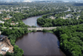
Robinson's Branch Reservoir in Clark, New Jersey. The Garden State Parkway bridge is seen crossing over the reservoir
-
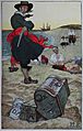
Howard Pyle's fanciful painting of Kidd burying treasure


