
Arthur Kill facts for kids
Quick facts for kids Arthur Kill |
|
|---|---|

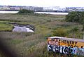
Aerial view of Arthur Kill, with the Rahway River joining from the left and Prall's Island visible near center.
|
|
| Country | United States |
| State | New York, New Jersey |
| Municipalities | Staten Island (New York), Union County (New Jersey), Middlesex County (New Jersey) |
| Physical characteristics | |
| Main source | Newark Bay 40°38′47″N 74°10′47″W / 40.64639°N 74.17972°W |
| River mouth | Raritan Bay 40°30′01″N 74°15′31″W / 40.50028°N 74.25861°W |
The Arthur Kill is a narrow waterway, like a river, that separates Staten Island in New York from Union and Middlesex counties in New Jersey. It's also sometimes called the Staten Island Sound. This important channel helps ships move in and out of the busy Port of New York and New Jersey.
Contents
What's in a Name? The Meaning of Arthur Kill
The name Arthur Kill comes from the Dutch language. The Dutch word achter kill means "back channel." This name was given a long time ago, in the early 1600s. At that time, the area was part of a Dutch colony called New Netherland.
The word kill itself comes from the Middle Dutch word kille. This word means "riverbed," "water channel," or "stream." So, Arthur Kill basically means "back channel." It was called this because it was "behind" Staten Island.
Exploring the Geography of Arthur Kill

The Arthur Kill is about 10 miles (16 km) long. It connects Raritan Bay in the south to Newark Bay in the north.
On the New Jersey side, you'll mostly see factories and industrial areas. This part is sometimes called the Chemical Coast. On the Staten Island side, there are many natural salt marshes. This side is also home to the Staten Island boat graveyard. The waterway also borders Fresh Kills Landfill and Freshkills Park.
How the Channel Was Formed

The Arthur Kill was once a river channel carved by an ancient version of the Hudson River. This happened when the main Hudson River channel was blocked by ice or rocks. The large size of the Arthur Kill suggests it was once the main waterway for the region.
Water Flow and Wildlife
The way water flows in the Arthur Kill is complex because of the tides in the New York–New Jersey Harbor Estuary. In the 1960s and 1970s, the water was very polluted. Few fish could survive there. But since the 1990s, the water has become much cleaner. Now, you can find crabs, baitfish, striped bass, and bluefish living in the water again.
Islands and Smaller Waterways
The Arthur Kill has two small islands that no one lives on: Prall's Island and the Isle of Meadows. Both of these islands are part of Staten Island.
Several smaller rivers and creeks flow into the Arthur Kill:
- From New Jersey: The Elizabeth River, Rahway River, Morses Creek, and Piles Creek.
- From Staten Island: Old Place Creek, Fresh Kills (which is part of Freshkills Park), Bridge Creek, and Sawmill Creek.
Shipping and Industry on Arthur Kill

The Arthur Kill is a very busy waterway for ships. It allows large tanker ships to reach factories and industrial sites along its banks. The Howland Hook Marine Terminal, a big shipping port, is located at the northern end. The waterway also provided access to the now-closed Fresh Kills Landfill on Staten Island. It is also the site of the Staten Island boat graveyard.
To keep the channel useful for big ships, it is regularly dredged. This means the bottom is dug out to make it deeper. The channel is usually kept at a depth of 35 to 37 feet (11 to 11 m) and a width of 600 feet (180 m). As part of a project to make the harbor deeper, the Arthur Kill is being dug out to 50 feet (15 m) deep. This will allow even larger ships to pass through with full loads.
Bridges and Ferries Across the Kill

Several bridges cross the Arthur Kill, connecting Staten Island to New Jersey:
- The Goethals Bridge
- The Outerbridge Crossing
- The Arthur Kill Vertical Lift Bridge, which is a railroad bridge. It is the largest bridge of its kind in the United States.
For many years, ferries also crossed the Arthur Kill. One ferry ran between Tottenville on Staten Island and Perth Amboy, New Jersey. Another ferry went from Travis, Staten Island, to Carteret, New Jersey. There are plans to bring back ferry service between Carteret and Midtown Manhattan. As of 2021, money was set aside to build a dock and buy a boat for this new service.
A Look Back: History of Arthur Kill
The Arthur Kill was an important dividing line during the American Revolution. The British army controlled Staten Island throughout the war. However, New Jersey mostly remained under the control of the American Continental Army. Many small battles, including the Battle of Staten Island, took place across the Arthur Kill.
As of 2017, there were discussions about a planned Pilgrim Pipeline. This pipeline would carry crude oil, kerosene, and diesel fuel through New York and New Jersey. It is expected to end near the Arthur Kill in Linden, New Jersey.
Images for kids
-
As seen from Staten Island, with Carteret, New Jersey, in the background and small creek in foreground

