
Elizabeth River (New Jersey) facts for kids
Quick facts for kids Elizabeth River |
|
|---|---|

|
|
| Country | United States |
| State | New Jersey |
| Region | Essex Union |
| Physical characteristics | |
| Main source | Watchung Mountains surfaces Irvington/Newark 40°44′12″N 74°13′43″W / 40.736566°N 74.228531°W |
| River mouth | Arthur Kill Elizabeth 0 ft (0 m) 40°38′39″N 74°11′24″W / 40.6441°N 74.1900°W |
| Length | 11.9 mi (19.2 km) |
The Elizabeth River is a small river in New Jersey, United States. It flows for about 11.9 miles (19.2 km) through Essex and Union counties. Finally, it empties into the Arthur Kill, which is a tidal strait.
Contents
Where the River Flows
The Elizabeth River starts in East Orange in Essex County. This starting point is called the headwaters. It begins in a city area, right where Irvington meets the Vailsburg part of Newark.
The river flows mostly south. In Irvington, it runs through a special concrete channel with stone walls. This channel was built a long time ago, in the 1920s and 1930s. It passes by Civic Square and then along the east side of the old Clinton Cemetery.
After the cemetery, the river goes under the Garden State Parkway. For a short distance, it actually disappears underground!
River's Path in Union County
The Elizabeth River comes back to the surface just south of the Union County line. This is near the Garden State Parkway Interchange 142. It then flows under I-78 and through the Elizabeth River Parkway.
Here, a smaller stream called Lightning Brook joins the Elizabeth River. The river then goes under the Garden State Parkway again. After passing under US 22, it turns east. Another branch, the West Branch Elizabeth River, flows into it.
The river then passes by important places like historic Liberty Hall and Kean University. In this area, many parts of the river are held in place by levees. Levees are like small walls built to stop the river from overflowing.
Reaching Elizabeth City
When the river reaches Elizabeth, it flows for about 4 miles (6.4 km). It goes under many bridges. A large part of the river in Elizabeth is also channelized. This means its path has been changed and made straighter by human-made channels. Finally, at the bridge on South Front Street, the Elizabeth River flows into the Arthur Kill.
Elizabeth River Parkway

The Elizabeth River Parkway is a series of parks that follow the river. It stretches from Hillside all the way through Elizabeth. This park system was planned in the 1920s by a famous design company called Olmsted Brothers.
It's one of three "emerald necklaces" in the county park system. An "emerald necklace" is a group of connected parks and green spaces that look like a necklace around a city or area. The other two are the Rahway River Parkway and the Passaic River Parkway. The Olmsted Brothers also designed Warinanco Park.
Elizabeth River Trail
The Elizabeth River Trail is a special project. It's building a park and a path along the river. The trail will go from South Broad Street in Downtown Elizabeth to where the river meets the Arthur Kill. This is a distance of about 2.5 miles (4 km).
The first part of the trail opened in 2012. It runs between Broad and Bridge streets, near St. John's Parsonage. The second part of the trail was finished and opened in August 2018. It's a great place for people to walk, run, and enjoy nature by the river.
Images for kids
-
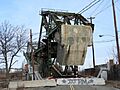
The South Front Street Bridge, one of many crossings over the Elizabeth River.
-
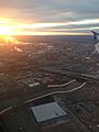
The Elizabeth River as seen from above, near the New Jersey Turnpike.

_Exit_13_and_Union_Freeway_(Interstate_278)_in_Elizabeth,_New_Jersey_from_a_plane_heading_for_Newark_Airport.JPG)
